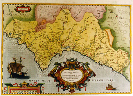
Cartographica Neerlandica Background for Ortelius Map No. 29

Title: VALENTIAE REGNI, | "olim" | CONTESTANORVM SI PTO:|LEMAEO, EDETANORVM | SI PLINIO CREDIMVS | TYPVS [Map of the Kingdom of Valencia, once called Contestani if we may believe Ptolemæus or Edetani if we may believe Plinius] (cartouche upper left:) "Cum priuilegio ad decen:|nium.1584". [With a privilege for ten years. 1584]. Upper right: "Limes vetus inter Valentiam et Arragoniam. Limes nouus inter Valentiam et Arragoniam." [The old/new border between Valencia and Arragonia.]
Plate size: 349 x 503 mm
Scale: 1 : 700,000
Identification number: Ort 29 (not in Koeman, Meurer or Karrow, van der Krogt AN: 6155:31A)
Occurrence in Theatrum editions and page number: this plate occurs in
1584L3Addblank (100 copies printed) (identical to 1584L, but here without page number; last line, left aligned: diem;conniuentibus Rege & Inquisitione.),
1584L18 (750 copies printed) (identical to 1584L3Add, but here with page number; last line, left aligned: diem;conniuentibus Rege & Inquisitione.),
1584G3Add. page number 7 in upper right corner; (75 copies printed) (last line: gen tag/sintemal der König sampt der Inquisition durch die finger sehen.)
1585F3Add8 (75 copies printed) (last line, left aligned: sent rien.),
1587F18 (250 copies printed) (last line, left aligned: broise Morale.)
1588S18 (300 copies printed) (last line, left aligned: se podran veer algunos en el dicho Beuthero,y en Ambrosio Morales.),
1592L editions (some) with the same text as 1584L, also with page number 18 or 19. (525 copies printed) (The 1592L copy with page number 18 as well as with page number 19 ends: rico Furio Cæriolano Valentino accepi.),
I also found a copy of Ort29 in a 1602S edition without a page number.
Approximate number of copies printed: when I first estabished that this map was different from the later Ort30, I estimated that no more than about 200 copies were printed, of which about 10 in circulation. Closer inspection reveals that its successor Ort 30, which has far superior engraving, although it is dated 1584 just as the present map, only began to be used exclusively as late as 1595. Thus, the present maps was predominantly or exclusively used throughout the period 1584 to 1592. Therefore, the number of copies printed is now estimated at about 1400, and the number of copies circulating at perhaps 100.
States: 29.0 Meurer reports a copy in Grenoble with the date 1582 on it.
29.1 as described.
Cartographic sources: unidentified (Meurer p. 96). Brandmair suggests Curius Cæriolanus as a possible source, see also Hessels nr. 173, where Arias Montanus provides information to Ortelius on Cæriolanus. Vicente Garcia of the University of Castellon, who has researched this area concerning its cartographic history, (personal communication) suggest that this map is based on a map of Valencia by Jeronimo Munyos of 1568, see also under references.
References: A. Hernando "The contribution of Ortelius'Theatrum to the Geographical Knowledge of Spain. p. 239-262 in Van den Broecke, van der Krogt & Meurer (eds.) "Abraham Ortelius and the First Atlas, 1998, HES Publishers. Roselló, V.M. (2000) Jeroni Munyós i la primera trangulació valenciana (per A. Oertel?), Cuadernos de Geografía, Valencia, Facultat de Geografia i Història, Universidad de Valencia 67/68 pp. 137. Based on a manuscript map of 1568 (using survey methods of Gemma Frisius) in Bib. Apost. Vat., MS. VL 6998, this reference suggests that these results formed the source for Ortelius' Valentiae Regni map.
Remarks: Succeeded by plate Ort 30, which is very similar, but which has cursive rather than straight capitals for "MARIS|MEDITERRANEI PARS" at the bottom in the sea area. According to the Dutch expert in early engraving Gerrit Noordzij, the quality of the engraving of this map Ort29 was too poor to warrant regular inclusion of this plate in the Theatrum.
For questions/comments concerning this page, please e-mail info@orteliusmaps.com.