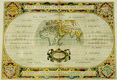
Cartographica Neerlandica Background for Ortelius Map No. 186

Title: AEVI VETERIS, TYPVS GEOGRAPHICVS. [A geographical map of the old world]. (Lower centre cartouche:) "Abrah. Ortelius Regić Mts. | Geographus describ. cum Privilegijs de:|cennalib. Imp. Reg. et Cancellarić Brabantić. | Antverpić Ambivaritorum. | 1590". [Designed by Abraham Ortelius geographer of his Royal Majesty. with imperial, royal and council of Brabant privilege at Antwerp. 1590.] (Bottom cartouche:) EN SPECTATOR, PILAE TOTIVS TERRAE ICHNOGRAPHIAM : AT VETERIBVS, VSQVE AD ANNVM SALV:|TIS NONAGESIMVM SECVNDVM SVPRA MILLES.QVADRINGENT. COGNITĆ, TANTVM GEOGRAPHIAM. [Spectator, see here an ichnography or puzzle picture of the entire world, as also of the entire geography known to the ancients until the salutary year 1492]. (Spread over the map, from top to bottom:) Zona frigida et inhabitabilis. | "Circulus Arcticus Sive Borealis" | Zona temperata, et habitabilis. | "Tropicus Cancri, Sive Aestivalis". | Zona torrida, et ob solis nimium | fervorem a veteribus inhabitabilis credita. | "Aequinoctalis, sive Aequidialis circulus. | Tropicus Capricorni, Sive Hyemalis" | Zona temperata, et habitabilis. | "Circulus Antarcticus, Sive Australis" | Zona frigida, et inhabitabilis. [Barren and uninhabitable zone. The Arctic or Northern circle. Tempered and inhabitable zone. The tropic of Cancer, or Summer circle. Dry zone, and because of the excessive heat of the sun by the ancients considered to be uninhabitable. Equator or circle of days of the same duration. The tropic of Capricorn, or Winter circle. Temperate and inhabitable zone. The antarctic or Southern circle. Barren and uninhabitable zone.]
Plate size: 315 x 444 mm.
Scale: 1 : 90,000,000.
Identification number: Ort 186 (Koeman/Meurer: 13P, Karrow: 1/173, vdKrogtAN: 0800H:31).
Occurrence in Theatrum editions and page number:
1590L4Addblank (100 copies printed) (last line, right column, centred, identical in text and typesetting to 1592L but here without page number: descriptiones meliores,tum iambi quibus eam ornasti.),
1591G4Addblank (75 copies printed) (last line, centred like 5 lines above it, in Gothic script: gerahten.),
1592L1 (525 copies printed) (identical in text and typesetting to 1590L4Add but here with page number 1: last line, left column: Dominitianus Imper. occidit Metium Pomposianum, quňd de- ; right column: descriptiones meliores,tum iambi quibus eam ornasti.),
1595LA (500 copies printed) (last line, left column: Dominitianus Imper. occidit Metium Pomposianum, quňd; right column, centred, italic: "Cogimur č tabula pictos ediscere mundos".),
1598/1610/1613D85 (100 copies printed) (last line, centred like 3 lines above it: ghy dien mede verciert hebt.),
1601Lvj (200 copies printed) (last line, in two columns, first column: Theophrastum Eresium tabulas quibus Orbis situs sunt ; second column, in italic script: "Cogimur č tabula pictos ediscere mundos."),
1602G1 (250 copies printed) (last line, centred like 7 lines above it, in Gothic script like the entire text: gerahten.),
1603Lvj (300 copies printed) (text and page number, but not typesetting, identical to 1609/1612S/L; 9th line from the bottom right column ends: non ; last line, in two columns, right column italic, first column: Theophrastum Eresium tabulas quibis Orbis si- ; second column: "Cogimur č tabula epictos edificere mundos."),
1606Evj (300 copies printed) (last line, two columns, italic like the second half of the text, first column: "stament, certaine mappes in which were described the" SITVA-; second column: "We forced are to understand : By charts,the state of Sea and Land".),
1608/1612Ivj (300 copies printed) (last line, in two columns like 32 lines above it: Diogene Laertio scriue nella vita di Teofrasto Eresio, ch'e- ; "Siamo sforzati imparar li mondi depinti in tauola."),
1609/1612L/Svj (600 copies printed) (text and page number, but not typesetting, identical to 1603L; 9th line from the bottom, right column, ends: ta- ; last line, in two columns, right column italic, first column: Theophrastum Eresium tabulas quibis Orbis si- ; second column: "Cogimnr č tabula epictos ediscere mundos."),
1624ParergonL/1641Sviij (1025 copies printed) (last line second column first text page, in cursive script: "uaserit." ; last line second column, second text page, in cursive script: "Cogor vt č Tabula pictos ediscere mundos".).
Approximate number of copies printed: 4275.
States: 186.1 as described.
186.2: between 1595 and 1598, TAPROBANA was removed from Sumatra and Taprobana was added to Sri Lanka.
Ornamental borders and inset maps 186b Europe, 186c America, 186d Asia and 186e Africa are worn out.
Cartographic sources: made by Ortelius on the basis of ancient knowledge. Seventeen classical authors and their works are specifically mentioned. Later discoveries prior to Columbus, viz. in the South and East Asia by the Portuguese, and in the North by Richard Hakluyt are also referred to.
References: Shirley map 176, plate 143, pp. 193-194.
Remarks: Shirley notes the occurrence of this map in the Appendix of the Mercator-Ptolemy atlas of 1618-1619.
For questions/comments concerning this page, please e-mail info@orteliusmaps.com.