Cartographica Neerlandica Background for Ortelius Map No. 53

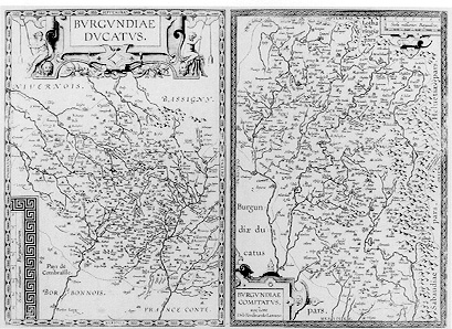
Title: BVRGVNDIAE | DVCATVS. 1597. [The Duchy of Burgundy, 1597]. - BVRGVNDIAE | COMITATVS | auctore | Dño Ferdinando Lannoyo. [The county of Burgundy by Mr. Ferdinandus Lannoyus]. (Above centre of right map:) "Hoc antrum hyeme | feruet, ĉstate autem | frigore riget". [In winter this cave is hot, but in summer it freezes because of the cold.] (Middle of right edge:} "Iougne. Hic vectigal | exigitur, rerum quĉ alio | exportantur". [Iougne. Here taxes are levied on goods that are exported.]
Plate size: 360 x 502 mm. Two maps on one plate.
Identification number: Ort 53 (Koeman/Meurer: 142ab, not in Karrow).
Title 53a: Burgundiĉ Ducatus
Scale: 1 : 350,000.
Size: 360 x 250 mm.
Identification number: Ort 53a (Koeman/Meurer: 142a, van der Krogt AN: 4870:31B).
States: 53a.1 as described.
53a.2: between 1612 and 1641, the date 1597 was removed from the cartouche.
Cartographic sources: a source of this plate has not been identified with certainty. In contents, the map resembles Mercator's 1585 map of Burgundy. The Catalogus Auctorum in the Theatrum mentions Etienne Tabourot's Burgundy as not yet having appeared (Meurer p. 88-89).
Title 53b: Burgundiĉ Comitatus
Scale: 1 : 350,000.
Size: 360 x 246 mm.
Identification number: Ort 53b (Koeman/Meurer: 142b, van der Krogt AN: 4880:31B).
States: 53b.1 as described;
53b.2: between 1612 and 1641, on the upper right side of the plate three horizontal lines were added where apparently the plate had been empty before.
Cartographic sources: Ferdinand de Lannoy made a map of Burgundy in 1563 for which he obtained a privilege, but which was subsequently suppressed by the Spaniards for political reasons. Ortelius was familiar with this map as early as 1570 (Karrow 48/2.1, p. 332-333; Meurer p. 180).
Occurrence in Theatrum editions and page number:
1602S34,35 (250 copies printed) (last line first text page, right aligned: adonde; last line second text page, left aligned: gyrico de Nazario dedicado al Emperador Constantino.),
1608/1612I38 (very few if any, 25 copies printed?),
1609/1612S36 (very few, 25 copies printed?) (text, but not typesetting identical with 1641S; last line first text page, right aligned: adonde ; last line second text page, left aligned: gyrico de Nazario dedicado al Emperador Constantino.),
very few 1609/1612L37 (25 copies printed?),
1641S36 (25 copies printed) (text, but not typesetting identical with 1609/1612S; last line first text page, right aligned: Rosne ; last line second text page, left aligned: cez. De los Ĉduos antiguos lea el Panegyrico de Nazario dedicado al Emperador Constantino.).
Approximate number of copies printed: 325.
Remarks: see also plates Ort 51, Ort 52 and Ort 54. The text below is for the first part very similar to earlier texts of Ort 51 and Ort 52. This is the rarest Burgundy map of the four that Ortelius made.
For questions/comments concerning this page, please e-mail info@orteliusmaps.com.