Cartographica Neerlandica Background for Ortelius Map No. 44

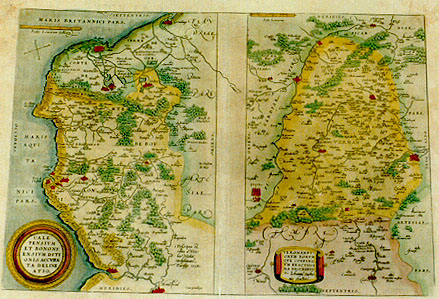
Title: CALE:|TENSIVM | ET BONONI:|ENSIVM DITI:|ONIS ACCVRA:|TA DELINE|ATIO [An accurate representation of the area of Calais and Boulogne] "Cum priuilegio" [With privilege] (lower right:) "Descripta & | edita a Nico:|lao Nicolai Delphinate | Parisijs 1558". [Drawn up and edited by Nicolaus Nicolai Delphinatis from Paris 1558] [middle left] "Toutte la fosse de Boullonnois a de | circuit de 26. lieues". [The entire Boulogne stream has a circumference of 26 miles.] - VEROMANDV:|ORVM EORVM | QVE CONFINI:|VM EXACTISSI:|MA DESCRIPTI:|O. "Iohanne Surho:|nio Auctore". [A most exact representation of Vermandois and its borders by Iohannes Surhonius].
Plate size: 338 x 484 mm. Size 44a: 338 x 236 mm; Size 44b: 338 x 213 mm. Two maps on one plate.
Identification number: Ort 44.
Title 44a: Caletensium
Scale: 1 : 200,000. Size: 338 x 236 mm.
Identification number: Ort 44a (Koeman/Meurer: 11a, Karrow: 1/17, Van der Krogt AN: 4120:31A).
States: 44a.1 as described.
44a.2: from 1584L onwards, dot pattern in the sea North and West of Grevelinge which used to be in vertical columns now a random pattern.
44a.3: from 1587F onwards, hachuring along coastlines extended from about 3 to about 6 mm. North side of mouth of river Aa vertical hachuring has been replaced by horizontal hachuring.
Cartographic sources: Nicolas de Nicolay (1517-1583) published a four-sheet map of this area between Boulogne and Calais in 1558 in Paris (Meurer p. 207-208, Karrow 59/5 p. 438). Brandmair claims on the authority of Nordenskj÷ld that this map was in turn based on Medina's Arte de Navigar.
Title 44b: Veromanduorum
Scale: 1 : 200,000. Size: 338 x 213 mm.
Identification number: Ort 44b (Koeman/Meurer: 11b, Karrow: 1/18, van der Krogt AN: 4160:31A).
States: 44b.1 as described.
44b.2: from 1584L onwards most horizontal underlining of woods receive vertical lines as well.
Cartographic sources: Jean de Surhon received royal privilege in 1557 to make a map of Vermandois. It was published a year later in Antwerp by Arnold Nicolai (Meurer p. 251, Karrow 74/2, p. 517-518).
Occurrence in Theatrum editions and page number:
1570L(AC)11 (225 copies printed) (last line, in italic script, centred like one line above it: "libello antiquitatum GalliŠ BelgicŠ."),
1570L(B)11 (100 copies printed) (last line, centred like one line above it: Diuei,in libello antiquitatum GalliŠ BelgicŠ.),
1571L11 (275 copies printed) (last line, centred like one line above it: Diuei,in libello antiquitatum GalliŠ BelgicŠ.),
1571/1573D11 (350 copies printed) (last line, in cursive script like the entire text, centred like 2 lines above it: "malcanderen haer beghintsel nemen".),
1572/1574F11 (225 copies printed) (last line, centred like 4 lines above it: loing les vnes les autres.),
1572G11 (pasted over p.11 of a 1570L edition; few copies printed)(last line, left aligned, in Gothic script except for Latin names: zeit nichts dann ein Closter uberig/Besihe von disen V÷lckern Petri Diuei BŘchlein/ von den Antiquiteten GalliŠ BelgicŠ des Niderlandes.),
1572/1573G11 (225 copies printed) (last line, cursive like the entire Vermandois text, centred like 4 lines above it: "jren anfang nemen."),
1573L(AB)15 (75 copies printed) (last line, centred: Petri DiuŠi,in libello Antiquitatum GalliŠ BelgicŠ. A and B version identical for this map.),
1574L15 (175 copies printed) (large page number, 11 mm; first letter of title VEROMANDVI above last letter of HVNC in next line; last letter of title VERMANDVI is above first letter of hodie in next line; last line, centred like one line above it: DivŠi, in libello Antiquitatum GalliŠ BelgicŠ.),
1575L15 (100 copies printed) (small page number, 7 mm; first letter of title VEROMANDVI above second letter of HVNC in next line; last letter of title VEROMANDVI is above space between hodie and adhuc in next line; last line, centred like one line above it: DiuŠi, in libello Antiquitatum GalliŠ BelgicŠ.),
1579L(A)20 (250 copies printed) (last line, left aligned: populis sententiam Petri DiuŠi,in libello Antiquitatum GalliŠ BelgicŠ. ; fourth text line from the bottom of the text above VERMANDVI ends: Bolo-),
1579L(B)20 (250 copies printed) (last line, left aligned: populis sententiam Petri DiuŠi,in libello Antiquitatum GalliŠ BelgicŠ. ; fourth textline from the bottom of the text above VERMANDVI ends: Bo-),
1580/1589G20 (350 copies printed) (last line, centred like 4 lines above it, in Gothic script: namen Belgica gedeutet wirt.),
1581F20 (400 copies printed) (last line, centred like 3 lines above it: loing les vnes des autres.),
1584L24 (750 copies printed) (last line, left aligned: de iis populis sententiam Petri DiuŠi, in libello Antiquitatum GalliŠ BelgicŠ.),
1587F24 (250 copies printed) (last line, centred like 7 lines above it: des autres.),
1588S24 (300 copies printed) (last line, full width: sentencia de Pedro DiuŠo,en su librito de las antiguedades de la Gallia Belgica.),
1592L25 (525 copies printed) (last line, left aligned: GalliŠ BelgicŠ.),
1595L26 (500 copies printed) (last line, left aligned: Petri DiuŠi,in libello Antiquitatum GalliŠ BelgicŠ.),
some 1598D21 (25 copies printed?).
Approximate number of copies printed: 5350.
Remarks: from 1598F onwards, this plate has been replaced by Ort 45, in which Veromanduorum has North at the top, whereas here on Ort 44b South is at the top. Note that in Ort 44a the North is not quite at the top of the map, as indicated by the magnetic arrow in the sea, which points to the real North.
For questions/comments concerning this page, please e-mail info@orteliusmaps.com.