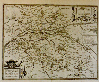
Cartographica Neerlandica Background for Ortelius Map No. 42

Title: Touraine. | TVRONENSIS | DVCATVS | et | CONFINIVM GALLIÆ | CELTICÆ DESCRIPTIO. [A Depiction of Touraine, the duchy of the Turones and of the borders of Celtic France] (panel lower left corner:) "Perlustrata & descripta hæc | regio est ab Ysaaco Franco | Regio Ædili, nec non in ea | provincia Viarum magistro. | Anno Domini" MDXCII. [This region has been explored and drawn up by Isaac Francus, inspector and surveyor of the roads of the area, in the year of the Lord 1592], cartouche with 5 lines of geographical information, middle right: "Complectitur hic ducatus latitudo ab | æquinoctali versus Arcticum ad 47.gra: | dum,49 minutos porrigitur. Longitudo | vero àb Occidente in Orientem ad 21. | gradum 27.minutos extenditur". [This duchy extends at a latitude from the æquator towards the North for 47 degrees and 49 minutes, and in longitude from the West towards the East for 21 degrees and 27 minutes].
Plate size: 362 x 462 mm
Scale: 1 : 200,000
Identification number: Ort 42 (Koeman/Meurer: 137, Karrow: 1/212, van der Krogt AN: 4380:31).
Occurrence in Theatrum editions and page number:
1598F27 (525 copies printed) (last line, left aligned: Beaulieu,&c.les quels voyez es liures de Belleforest.),
1601L25** (200 copies printed) (last line, left aligned: ditionis huius vrbes Belleforestius descripsit,quem lege.),
1602G27 (some copies have page number 28)(250 copies printed) (last line, left aligned, in Gothic script like the entire text: welchen man lesen kan.),
1602S27 (250 copies printed) (last line, left aligned: las de esto dominio, Belforestio las descriuio,al qual podras leer.),
1603L27 (300 copies printed) (last line, left aligned: que ditionis huius vrbes Belleforestius descripsit, quem lege.),
1606E25¶¶ (300 copies printed) (last line, italic like most of the text, left aligned: "scribed by" Belleforest, "vnto whom I referre the Reader".),
1608/1612I30 (300 copies printed) (last line, left aligned: il quale se ben ti torna leggi.),
1609/1612/1641S29 (325 copies printed) (last line, left aligned: dras leer.),
1609/1612L29 (300 copies printed) (last line, left aligned: que ditionis huius vrbes Belleforestius descripsit, quem lege.).
Approximate number of copies printed: 2425.
States: 42.1 only.
Cartographic sources: Isaac François or Ysaacus Francus (1566-1649) contributed a map of Touraine to Bougereau's Théatre François in 1594 which was used by Ortelius (Meurer p. 146).
For questions/comments concerning this page, please e-mail info@orteliusmaps.com.