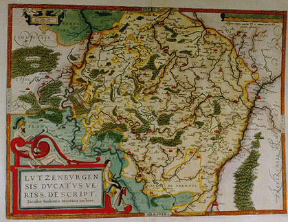
Cartographica Neerlandica Background for Ortelius Map No. 60

Title: LVTZEMBVRGEN|SIS DVCATVS VE:|RISS. DESCRIPT. | Iacobo Surhonio Montano auctore. [A very true representation of the duchy of Luxemburg, by Iacobus Surhonius Montanus] (upper left cartouche:) "Cum Priuilegio Imp. & | Regie Maiestatuum". [With a Privilege of the emperor and his royal majesty].
Plate size: 368 x 499 mm
Scale: 1 : 400,000
Identification number: Ort 60 (Koeman/Meurer: 79, Karrow: 1/114, van der Krogt AN: 3380:31)
Occurrence in Theatrum editions and page number:
1579L2Add18a (250 copies printed) (last line, left aligned: scriptio est apud Ludouicum Guicciardinum.),
1579L(A)26 (250 copies printed) (last line, left aligned: scriptio est apud Ludouicum Guicciardinum.),
1579L(B)26 (250 copies printed) (last line, left aligned: bus exercitatum scribit.),
1580G2Add18A (50 copies printed),(last line, centred like 3 lines above it, in Gothic script: Guicciardinium.),
1580/1589G26 (350 copies printed) (last line, centred like 3 lines above it, in Gothic script: Guicciardinium.),
1581F26 (400 copies printed) (last line, left aligned, in cursive script like the entire text: "plus ample description chez Louys Guicciardin".),
1584L31 (750 copies printed) (last line, left aligned: exercitatum scribit.),
1587F31 (250 copies printed) (last line, left aligned, in cursive script like the entire text: "plus ample description chez Louys Guicciardin".),
1588S31 (300 copies printed) (last line, left aligned: lib. 2.adonde escriue que se exercitaua en la caça Carolo Magno.),
1592L33 (525 copies printed) (last line, left aligned: tum scribit. Plura de hac regione in nostro Itinerario.),
1595L35 (500 copies printed) (last line, left aligned: Magnum venationibus exercitatum scribit.Plura de hac regione in nostro Itinerario.),
1598/1610/1613D27 (100 copies printed) (last line, left aligned: dovicum Guicciardinum blijckende is.),
1598F38 (525 copies printed) (last line, italic like the entire text, left aligned: "plus ample description chez Louys Guicciardin".),
1601L35 (200 copies printed) (last line, left aligned: exercitatum scribit. Plura de hac regione in nostro Itinerario.),
1602G38 (250 copies printed) (last line, centred like 3 lines above it, in Gothic script like the entire text: Guicciardinum.),
1602S38 (250 copies printed) (last line, left aligned: Carolo Magno. Hallarase mas d'esta Region en el nuestro Itinerario.),
1603blank (Vri1) has no text or page number,
1603L38 (300 copies printed) (last line, left aligned, exercitatum scribit. Plura de hac regione in nostro Itinerario.),
1606E35 (300 copies printed) (last line, italic: "concerning this region you may reade in our Itinerarium or Iournall".),
1608/1612I42 (300 copies printed) (last line, left aligned: Magno s'elercitaua nella caccia. Piu cose pongo nel mio itinerario di questi paesi.),
1609/1612L41 (300 copies printed) (last line, left aligned: exercitatum scribit. Plura de hac regione in nostro Itinerario.).
1609/1612/1641S40 (325 copies printed) (last line, left aligned: rolo Magno.Hallarase mas d'esta Region en el nuestro Itinerario.),
Approximate number of copies printed: 6725.
States: 60.1 as above.
60.2: between 1581F and 1584L, some 83 place names were inserted, including the river name "Chier flu./Carus Latinis" which was added to the river running from Longwy southwards.
60.3: between 1584L and 1587F 4 further place names were added, including "Grammargny" just Northeast of "La Roche".
60.4: between 1592L and 1595L all ornaments and trees were re-engraved. The reclining figures around the cartouche now all have small hachuring squares, as has the contraption held between the knees of the rightmost figure.
60.5: after 1612S, "Theodorus Galle excudit Antverpiæ" was added below the cartouche.
Cartographic sources: Surhon made a manuscript map of Luxemburg for which he received 500 Livres from Charles V in 1551. For security reasons it was not published. Only in 1579, when Antwerpen was independent for a short time, did Ortelius use it. (Meurer p. 250-251). Ortelius mentions in his "Catalogus Auctorum" Luxemburg maps by Tilemanus Stella Sigensis (not yet published), by Christian Schrot, and Ioannes Scillius from Antwerp (likewise not yet published).
References: E. van der Vekene (1980) Les Cartes Géographiques de Duché de Luxembourg éditées au 16e, 17e et 18e siècles: Catalogue descriptif et illustré. 2nd ed. Luxembourg: Krippler-Muller, map 105A, p. 6-13.
For questions/comments concerning this page, please e-mail info@orteliusmaps.com.