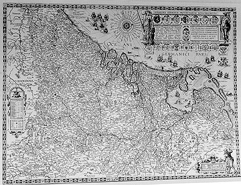
Cartographica Neerlandica Background for Ortelius Map No. 59

Title: INFERIORIS GERMANIĘ PROVINCIARVM NOVA DESCRIPTIO [A New Representation of the Provinces of Lower Germany]. (First state:)
"Germania inferior ob situm suam ita dicta et į quibus:|dam (sed valso) Belgium ab oriente Amasum,Episcopatus | Colonię, et Trevirum habet; ab austro Veromanduum et | Picardiam; ab occidente et septentrione Oceanum Rheno | Mosā, Scalde aliisque fluvijs piscium ac navium copiā | abundantibus perfunditur, et multis eximijs vrbibus atque | multitudine vicorum est exornata : Commodissimos ha:|bet portus, Incolę sunt solertes et diligentes omnium | bonarum artium amatores, milites strenui, egregij ac | perilissimi rerum nauticarum artifices".
(in the right half of the cartouche its translation into Dutch:)
"Neederlant dat om zijne geleghenheijt Neederduijtslant ende | van sommighe (maer tonrechte) Belgium wert ghenaemt heeft | de Eemse, de Bisdomen van Colen ende Trier aent Oosten Ver:|mandois ende Picardien aent Zuijden aent Westen ende | Noorden de Oceaen Wert met de Rijn Mase Schelde ende | andere Vischrijcke ende Schiprijcke rivieren bewatert ende | is verciert met seer veel heerlicke Steeden grote me:|nichte van schone Dorpen ende seer bequame Zehave:|nen. D'Inwoonders sijn subtil ende neerstich, Liefheb|bers van alle vrije consten dappere crijchsluijden | ende uijtnemende ervarerne Zeevaerders".
[in English: Netherlands which because of its situation is called Lower Germany and by some (but incorrectly) Belgium, has in the East the river Eems and the bishoprics of Cologne and Trier, in the South Vermandois and Picardy, and in the West and North the Ocean, watered by the rivers Rhine, Maas and Schelde, and other rivers with plenty of fish and ships, and it is ornated by very many wonderful cities, pleasant villages and commodious sea ports. Its inhabitants are subltle and diligent, lovers of all good arts, brave warriors and excellent sailors].
(left column second and third state:) "Harum Provinciarum Ius. Ditionemq. | vna cum Burgundię Comitatu, | PHILIPPVS ii. Hispp. Indiarumq. Rex | pridie Non. Maij MDXCIIX. | cessit ISABELLĘ CLARĘ EVGENIĘ | quę postea in manum convenit | ALBERTO Archiduci Austrio | belgarum hodie legitimo Principi". [Together with the Burgundian duchy, Philip II, king of Spain and the Indies, yielded the government over these provinces to Isabella Clara Eugenia on the 9th of May, 1598. After her marriage with Albert, duke of Austria, now the legitimate ruler of the Netherlands, they passed into his hands.](Right column:) DN. FRANCISCO SWEERTIO F. | ANTVERPIANO, VENERANDĘ/ | ANTIQVITATIS, SVMMO ADMI:|RATORI. IOAN.BAPT. VRINTIVS | AMORIS ERGO L.M.DD.[Libenter Meritoque Dedicavit]/MDCVI.KAL SEPT. [Out of friendship J.B. Vrients gladly dedicates this map to Franciscus Sweertius of Antwerp, the great admirer of classical antiquity, on the first of September 1606]. (The third state has the new imprint below Sweertius:) "Theodorus Gallęus excudit Antuerpię"
Plate size: 412 x 558 mm.
Scale: 1 : 1,000,000
Identification number: Ort 59 (Koeman/Meurer: 153, not in Karrow, van der Krogt AN: 3000:31B).
Occurrence in Theatrum editions and page number:
1608/1612I41 (300 copies printed) (last line above 3 columns of placenames: mi, che con diuersi vocaboli significano il medesmo concetto, nel nostro volgare d'alcuni luoghi.),
1609/1612L40 (300 copies printed) (last line above three columns of placenames, left aligned: lorum locorum synonyma vulgaria,huic paginę annectere volui.).
1609/1612/1641S39 (325 copies printed) (last line, in 2 out of 3 columns: "Tournay" dizen los naturales d'ella y tambien que el nombre: en Espańol "Terruana".),
Approximate number of copies printed: 925.
States: 59.1: only one copy is known of the first state, which must be dated before 1588 and which has left a Latin and right a Dutch text in the title cartouche.
59.2: the second state shows signs of erasure of text in the title cartouche, and has Latin text only in the cartouche.
59.3: The third state has the new imprint below Sweertius "Theodorus Gallęus excudit Antuerpię" and the polder Beemster has been reclaimed. It occurs with (post-1612) Spanish text or without text on verso and probably dates from before 1621, the year when Albrecht, Duke of Austria died. About ten copies are known.
59.4: the fourth state, dated as late as 1665 has a rewritten cartouche. The text in the two text-panels of the main cartouche are replaced by an extended title: NOVA ET ACCURATA DESCRIPTIO | XVII PROVINCIARVM | GERMANIĘ INFERIORIS/nec non | TERRITORII EMBDENSIS | MONASTERIENSIS, CLIVENSIS/JULIACENSIS, COLONIENSIS | ET MARCHIĘ TREVIRENSIS. [In a shield at the lower left corner a new imprint: "Antuerpię | Apud Ioannem Gallęum | 1665". Longitude and latitude degrees have been erased. Three copies are known.
Cartographic sources: this map, as well as a similar one made by Battista and Johannes van Deutecum in 1588, and another one made by Willem Blaeu in 1604, are based on a wall map of unknown authorship, published by Philip Galle in Antwerp in 1578, of which the first state of this map is probably a diminished version dating from around 1588. (Meurer p. 91-92).
References: H.A.M. van der Heyden (1987) "The Oldest Maps of the Netherlands", Utrecht, H&S, pp. 80-82, 148ff. G. Schilder (1987) "Monumenta Cartographica Neerlandica" II, Canaletto, p. 112 ff, 160-163. H.A.M. van der Heijden "Old Maps of the Netherlands, 1548-1794, Canaletto, Alphen aan de Rijn, Netherlands, 1998, map 32, pp. 81-84 and 212-215 (with an image of state 2 of this map on the cover). M. van den Broecke (2004) De eerste staat van Vrients'/Philip Galle's Inferioris Germanię kaart gevonden, "Caert-Thresoor" 23(1) pp 1-4.
Remarks: the copperplate of this map in its fourth state is shown in the Plantin Moretus museum in Antwerp.
For questions/comments concerning this page, please e-mail info@orteliusmaps.com.