Cartographica Neerlandica Background for Ortelius Map No. 55

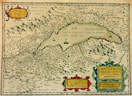
Title: (Cartouche low right:) LACVS LEMANI | VICINORVMQ. LOCORVM | NOVA ET ACCVRATA | DESCRIPTIO. (Cartouche middle bottom:) ORNATISS. DOCTISSIMOQ.VIRO | D. IACOBO COLIO ORTELIANO, | HANC LACVS LEMANI TABVLAM | IOAN. BAPT. VRINTIVS L.M. DEDICAB. | MDCVII.KAL.SEPTEMBRIS. [A new and accurate representation of Lac Leman and the places surrounding it. Ioannus Baptist Vrintius has willingly dedicated this map of Lac Leman to the most elevated and learned man Mr. Iacobus Colius Ortelianus [Ortelius' nephew] in the month of September 1607] (Oval cartouche in upper left corner, 5 lines of text:) "Beneuole lector | F. Franciam, G. Geneuam denotat. | Hæc volebam nescius ne eßes. | Vale & nostros conatus | boni consule". [Benevolent reader, F. refers to France, G. to Geneva. I would not like you to be not unaware of this. Be well and consult our work well.] (South-west of Geneva:) "Le Fort de S. | Catherine destruict | du Roy H. IIII." [The fortress of Saint Catherine, destroyed by King Henry the Fourth.] (Top left:) "Reliquæ muri | a I. Cæs. fact". [Remnants of walls made by Iulius Cæsar.] (Top right in lake:) "Tanta est lacus his in partibus profunditas | vt comperiri 500 orgyijs a nautis non potuerit". [In some parts of this lake the depth is such, that it cannot be compared by sailors to 500 orgyijs.(?)] (Extreme right, middle:) "Yvorne, | reversee par vn | tremblement de | terre, l'an 1584". [Yvorne, turned upside down by an earth quake in 1584].
Plate size: 374 x 514 mm.
Scale: 1 : 180,000
Identification number: Ort 55 (Koeman | Meurer: 152, van der Krogt AN: 4985:31).
Occurrence in Theatrum editions and page number:
1608/1612I39 (300 copies printed) (last line, left aligned: alli quali rimettiamo il Lettore.),
1609/1612L38 (300 copies printed) (last line, left aligned: quem remittendum putamus,si quis eius rei exactiorem notitiam desiderat.),
1609/1612/1641S37 (325 copies printed) (last line, left aligned: metimos el Lettor.).
Approximate number of copies printed: 925.
States: 55.1 only.
Cartographic sources: Jacques Goulart (born in 1580) provided the information for Jodocus Hondius' 1606 map of the area around the Lake of Geneva, which in turn was used by Vrients (Meurer p. 158-159).
For questions/comments concerning this page, please e-mail info@orteliusmaps.com.