Cartographica Neerlandica Background for Ortelius Map No. 37

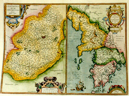
Title: CENOMANO:|RVM |Galliś regionis, typus. | "Auctore Matthśo Ogerio". [A map of the French region of the Cenomani by Mattheus Ogerius] La | Mans. - Neustria. BRI:|TANNIAE, | et | NORMANDI:|AE TYPVS. | "1594". [Le Mans - Neustria. A map of Bretagne and Normandy 1594] "Cum Priuilegio decennali." [With a privilege for ten years]. "OCEANVS | BRITANNI:|CVS, Vulgo Gallico | Manche; An:|glico Sleyfe: Teu:|tonico Kaniel. quasi dicas | Canal est enim canalis | instar, inter Galliam et | Angliam [The Britannic Ocean, in French Manche; in English Sleyfe: in German Kaniel, as if to say Canal, for it is a channel between France and England.]
Plate size: 373 x 504 mm. Two maps on one plate.
Identification number: Ort 37 (Koeman/Meurer: 127ab, Karrow: 1/188, 1/189)
Title 37a: Cenomanorum
Scale: 1 : 400,000. Size: 373 x 258 mm.
Identification number: Ort 37a (Koeman/Meurer 127a, Karrow 1/188, van der Krogt AN: 4430:31).
States: 37a.1 only.
Cartographic sources: Macť Ogier or Matthśus Ogerius, about whom we know little, produced a map of Le Mans in 1539 of which explanatory text appeared in 1558, and which was reprinted in 1565 (Meurer p. 209). A copy of this map was sent to Ortelius by Adam de la Planche, see Hessels nr. 279.
Title 37b: Neustria
Scale: 1 : 600,000. Size: 311 x 245 mm.
Identification number: Ort 37b (Koeman/Meurer 127b, Karrow: 1/189, van der Krogt AN: 4001:31).
States: 37b.1 as described.
37b.2: in 1641S, date removed.
Cartographic sources: various sources contributed, the most important one being Mercator's Britannia et Normandia map from his 1585 atlas of France. Specific details can de traced to Bertrand d'Argentrť (1519-1590), who made a map of Bretagne in 1588, and to Lťzin Guyet (1515-1580 or later) (Meurer p. 37, 208-209, 162).
Occurrence in Theatrum editions and page number:
1595L5Addblank (100 copies printed) (text and typesetting identical to 1595L but without page number; last line: possit:id quod in aulico comitatu in opido Blesensi experimÍto didici. Hoc Rob. Cúnalis in Gallica sua historia.),
1595L22 (500 copies printed) (text and typesetting identical to 1595L5Add, but here with page number 22; last line: possit:id quod in aulico comitatu in opido Blesensi experimÍto didici. Hoc Rob. Cúnalis in Gallica sua historia.),
1597G5Addblank (75 copies printed) (last line, centred like 3 lines above it, in Gothic script: erfahren zu haben bezeuget.),
1598F22 (525 copies printed) (last line, left aligned: Champenay, S. Aignan, Benestable, & plusieurs semblables.),
1601L22 (200 copies printed) (last line, left aligned: sensi experimento didici. Hoc Rob.Cúnalis in Gallica sua historia.),
1602G22 (250 copies printed) (last line, in Gothic script like the entire text, centred like 3 lines above it: erfahren zu haben bezeuget.),
1602S22 (250 copies printed) (last line, left aligned: tengo yo aprendido por experienca en vn banquette,en la villa Blessiensi. Todo esto escriue Rob. Cśnalis en su Historia Gallica.),
1603L22 (300 copies printed) (last line, left aligned: experimento didici. Hoc Rob. Cúnalis in Gallica sua historia.),
1606E22 (300 copies printed) (last line, left aligned: ence whereof,following the Court, I learned in the town of "Blois". Hitherto "Robert Cúnalis" in his history of "France".),
1608/1612I25 (300 copies printed) (last line, left aligned: presi con la corte nella terra di Bles per esperienza. Rob. Cenale nella Gallica historia ciÚ racconta.),
1609/1612/1641S24 (325 copies printed) (last line, left aligned: riencia en vn banquette, en la villa Blessiensi. Todo esto escriue Rob. Cúnalis en su Historia Gallica.),
1609/1612L24 or 25 (300 copies printed) (last line, left aligned: possit: id quod in aulico comitatu in opido Blesensi experimento didici. Hoc Rob.Cúnalis in Gallica sua historia.).
Approximate number of copies printed: 3425.
For questions/comments concerning this page, please e-mail info@orteliusmaps.com.