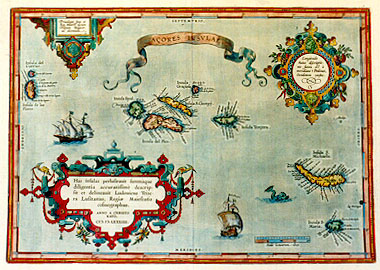
Cartographica Neerlandica Background for Ortelius Map No. 24

Title: AĒORES INSVLAE. (elaborate cartouche bottom left:) Has insulas perlustravit summaque | diligentia accuratissime descrip:|sit et delineavit Ludovicus Teise:|ra Lusitanus, Regię Maiestatis | cosmographus. | ANNO A CHRISTO | NATO,|MDLXXXIIII. [The Azores Islands. These islands have been scrutinised with the utmost diligence and have been described and drawn most accurately by Luis Teixera of Portugal, geographer of his Majesty the King, in the year after the birth of Christ 1584] (cartouche top left:) "Priuilegio Imp. et | Reg. Maiest. necnon | Ordinum Belgicor. | ad decennium". [With Imperial and Royal privilege, as well as that of the Belgian Office for ten years.] Elaborate cartouche top right, 5 lines of text: "Longitudo | huius descriptio:|nis sumta est ą | meridiano I Ptolemęi, | Occidentem versus". [the longitude of this depiction is taken from the first Ptolemęic meridian [towards the west]].
Plate size: 328 x 466 mm
Scale: 1 : 1,700,000
Identification number: Ort 24 (Koeman/Meurer: 95, Karrow: 1/136, van der Krogt AN: 6350:31)
Occurrence in Theatrum editions and page number:
1584L3Addblank (100 copies printed) (identical with 1584L, but here without a page number; last line, left aligned: mus,illi falso & leuiter S.Michaelis insulę tribuat.),
1584G3Add20 in upper right corner (75 copies printed) (last line, left aligned, in Gothic script: Michaelis zuschreibt.),
1585F3Add7 (75 copies printed) (last line, left aligned: montaigne, laquelle nous auons bien & au long descrite en l'Isle de Pico.),
1584L14 (750 copies printed)(identical with 1584L3Add, but here with page number; last line, left aligned: mus,illi falso & leuiter S.Michaelis insulę tribuat.),
1587F14 (250 copies printed) (last line, left aligned: montaigne , laquelle nous auons bien & au long descrite en l'isle de Pico.),
1588S14 (300 copies printed) (last line, left aligned: en la del Pico ; el falsa y liuianamente la atribuye a la Isla de S .Miguel.),
1592L15 (525 copies printed) (third line ends: "Esso-"; last line, left aligned: montis quam nos in Pico plenč descripsimus,ille falsņ & lęuč S.Michaėlis insulę tribuat.),
1595L15 (500 copies printed) (third line ends: "Essorer,"; last line, left aligned: montis quam nos in Pico verč & plenč descripsimus,ille falsņ & lęuč S.Michaėlis insulę tribuat.),
1598/1610/1613D14 (100 copies printed) (last line, left aligned, in Gothic script: recht toeschrijft.),
1598F15 (525 copies printed) (last line, left aligned: & au long descrite en l'Isle de Pico.),
1601L15 (200 copies printed) (last line, left aligned: Castellę.Item capite 97.Itinerarij Io.Hugonis Lindschotani.),
1602G15 (250 copies printed) (last line, left aligned, in Gothic script like the entire text: S. Michaelis zuschreibt.),
1602S15 (250 copies printed) (last line, left aligned: con el Reyno de Castilla. Item capite.97. Itinerarij Io.Hugonis Lindscotani.),
1603L15, (300 copies printed) (last line, left aligned: rarij Io.Hugonis Lindschotani. 9th line from the bottom ends: rivulus)),
1606E15 (300 copies printed) (last line, left aligned: of "Iohn Huighen van Linschoten" his East-Indian iournall.),
1608/1612I15 (300 copies printed) (last line, left aligned: di Castiglia, & il cap. 97. del viaggio di Gio. Vgone Lindscotano.),
1609/1612/1641S15 (325 copies printed) (last line, left aligned: Itinerarij Io.Hugonis Lindschotani.),
1609/1612L15 (300 copies printed) (last line, left aligned: rarij Io.Hugonis Lindschotani. 9th line from bottom ends: insulę),
Approximate number of copies printed: 5425.
States: 24.1 as described
24.2: after 1584 and before 1587 the word "Toletano" in the fourth line of the upper right cartouche was replaced by "I Ptolemęi".
24.3: most coastlines received an extended hachuring between 1588 and 1592, which was increased from about 2.5 mm to 5 mm.
Cartographic sources: Luis Teixeira's single sheet map of Terceira from 1582, which bears Ortelius' name and of which Meurer mentions one copy at the Bibliotčque Nationale in Paris, (also a copy in the city library of Cologne and a later manuscript map of the whole group of islands, to which Teixeira subsequently devoted an atlas. (Meurer p. 253-254).
For questions/comments concerning this page, please e-mail info@orteliusmaps.com.