Cartographica Neerlandica Background for Ortelius Map No. 206

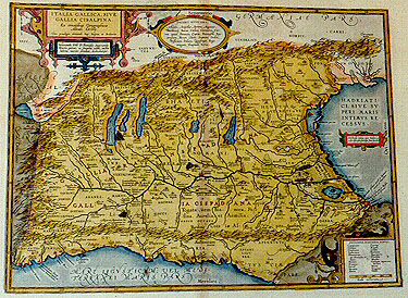
Title: ITALIA GALLICA, SIVE | GALLIA CISALPINA. | "Ex conatibus Geographicis | Abrah. Ortelij. | Cum priuilegio decennali, Imp. BelgicŠ, et BrabantiŠ. | Venerando D˝o D. Francisco Superantio | Veneto, pietate ac sanguine nobili, auctor | lubens merito donabat, dedicabatque". [French Italy or France beyond the Alps, from the geographical efforts of Abraham Ortelius, the author, with a ten year privilege from the emperor, Belgium and Brabant, who has given it and dedicated it with pleasure to Mr. Franciscus Superantius of Venice, pious and of noble descent.] (Cartouche middle right:) "Electrides insulas ante Padum, a | priscis descriptas. fabulosas facit Strabo". [The Electrides isles near Padum, described by the ancients, are by Strabo considered to be fantasized.] (One cartouche in middle top with 6 lines of placenames of uncertain location, one cartouche in bottom right corner with two columns of 12 and 11 peoples of uncertain location).
Plate size: 347 x 470 mm.
Scale: 1 : 1,400,000.
Identification number: Ort 206 (Koeman/Meurer: 21P, Karrow: 1/179, vdKrogtAN: 7010H:31).
Occurrence in Theatrum editions and page number:
1590L4Addblank (100 copies printed) (identical in text and typesetting to 1592L but here without page number; last line, left aligned: mo post initium belli Punici.),
1591G4Addblank (75 copies printed) (last line, centred like 3 lines above it, mostly in Gothic script: den samen aufffressen/etwas handelt.),
1592L10 (525 copies printed) (identical in text and typesetting to 1590L4Add, but here with page number 10; last line, left aligned: mo post initium belli Punici.),
1595LL (500 copies printed) (last line, left aligned: post initium belli Punici.),
1601Lxix (200 copies printed) (last line, left aligned: mo post initium belli Punici.),
1602G17 (250 copies printed) (last line, centred like 5 lines above it, in Gothic script like the entire text: was handelt.),
1603L few xix, mostly xxj (300 copies printed) (text and pagenumber, but not typesetting, identical with 1609/1612S/L; 11th line from the bottom begins "Meticoni"; last line, left aligned: scripta anno centesimo post initium belli Punici.),
1606Exix (300 copies printed) (last line first text page, cursive, full width: "Mannicelo ad floutum Edem,ibi terminus stat. Inde flouio suso vorsum in flouium Lemurim. Inde flouio Lemuri susum usque | ad" ; last line second text page, left aligned: seemeth to haue been written about one hundred yeare after the beginning of the Punick warre.),
1608/1612Ixxj (300 copies printed) (last line, left aligned: ˛ conseruata Parche ella fosse intagliata cento anni dopo il cominciamneto della guerra Cartaginese.),
1609/1612Sxxj (text in Latin) = 1609/1612Lxxj (600 copies printed) (text and page number, but not typesetting, identical with 1603L; 11th line from the bottom begins: "uersieis"; last line, left aligned: scripta anno centesimo post initium belli Punici.),
1624ParergonL/1641Sxxv (1025 copies printed) (last line second column first text page, right aligned, in cursive script: "nis" ; last line second text page second column, left aligned: tium belli Punici.).
States: 206.1: few road lines (see below).
206.2: in 1601, a number of lines representing Roman roads were added between cities along the South coast, and the road name "Aurelia via Antonino" appears along the road between Luna and PisŠ, bottom right. The place name "Vobernum" was added west of lake Benacus.
Approximate number of copies printed: 3550.
Cartographic sources: made by Ortelius on the basis of ancient knowledge from Livius, Ausonius, Tacitus, Cato, Plinius, Polybius and Cassiodorus.
For questions/comments concerning this page, please e-mail info@orteliusmaps.com.