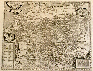
Cartographica Neerlandica Background for Ortelius Map No. 199

Title: GERMANIAE | VETERIS, | "typus. | Ex conatibus geographicis | Abrah. Ortelij". [Map of ancient Germany. From the geographical efforts of Abraham Ortelius]. (Cartouche upper right:) "Cum Priuilegio | Imperiali, Regio, et | Belgico, ad decenn. | 1587". [With Imperial, Royal and Belgian Privilege, for ten years. 1587.] (Cartouche bottom right:) DN. IACOBO MONAVIO SILESIO | PATRICIO VRATISLAVIENSI, | VIRO ET ERVDITIONE ET HV:|MANITATE ORNATISSIMO, ABRA:|HAMVS ORTELIVS HOC MVTVAE | AMICITIAE MONVMENTVM LI:|BENS DONABAT DEDICABATQVE. [Abraham Ortelius freely dedicates and donates this monument in mutual friendship to lord Iacob Monavius, patrician from Silesia, a gentleman with the most splendid erudition as well as humanity.] (Cartouche bottom left:) DVBIAE | POSITIO:|NIS QVÆ:|DAM. [Places of uncertain location], (followed by a two-column list. At the bottom of this list:) "Locorum vocabula circa Caroli | Magni tempora prima nata ,| inter vetusta non numero.| ea itaque nec in ipsa tabula | neque hîc seorsum nominara | visum fuit". [Placenames which first arose around the times of Charles the Great, which I do not include among the ancient placenames, nor are they shown here].
Plate size: 363 x 459 mm.
Scale: 1 : 3,500,000.
Identification number: Ort 199 (Koeman/Meurer: 19P, Karrow: 1/177, van der Krogt AN: 2000H:31A).
Occurrence in Theatrum editions and page number:
1590L4AddLblank (100 copies printed) (identical in text and typesetting to 1592L, but here without page number; last line, first text page, right aligned,: murmu- ; last line, second text page, left aligned: tur hæc Germania,vt cum Tacito dicam;quieandem magis triumphatam quàm victam,liberè fatetur.),
1591G4Addblank (75 copies printed) (last line, first text page, right aligned, in Gothic script: habe ich; last line second text page, in Gothic script, left aligned: bungh/so dem Keyser "Aurelio Maximiano" zugeschrieben.)
1592L7 (525 copies printed) (identical in text and typesetting to 1590L4Add but here with page number 7; last line first text page, right aligned: murmu- ; last line second text page, left aligned: tur hæc Germania, vt cum Tacito dicam;quieandem magis triumphatam quàm victam,liberè fatetur.).
Approximate number of copies printed: 700.
States: 199.1 only.
Cartographic sources: made by Ortelius on the basis of the writings by the ancient authors Tacitus, Cæsar, Dionysus, Ptolemæus, Suetonius, Eutropius, Seneca, Plinius and Strabo.
References: P.H. Meurer "Ortelius as the Father of Historical Cartography", p. 133-159 in: M. van den Broecke, P. van der Krogt and P.H. Meurer (eds) "Abraham Ortelius and the First Atlas", HES Publishers, 1998.
Remarks: From 1595 onwards replaced by plate Ort 200, which has grade numbers inside the frame, where they are outside the frame on the early plate. The late plate also has GAL:|LIÆ | PARS in large capitals next to the lower left cartouche.
Much of the text given below was also used for Ortelius' booklet "Aurei Sæculi Imago" [Image of the Golden Age] which appeared in 1596 as a separate publication of which 500 copies were printed. This publication describes the characteristics and habits of the Germans in Roman times. Notably the sections 23-24, 26, 46-47 and 51-72 of the text below reappear in (almost) the same wording in the booklet "Aurei Sæculi Imago". For the complete text of "Aurei Sæculi Imago" printed in modern English, see under Ortelius' publications.
For questions/comments concerning this page, please e-mail info@orteliusmaps.com.