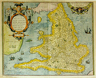
Cartographica Neerlandica Background for Ortelius Map No. 19

Title: ANGLIAE | REGNI FLO:|RENTISSIMI | NOVA DESCRIP:|TIO, AVCTORE | HVMFREDO | LHVYD DEN:|BYGIENSE 1573. [A new representation of England, a most flourishing kingdom, by Humphrey Llhuyd from Denbigh, 1573]. "Cum Priuilegio". [With Privilege].
Plate size: 382 x 468 mm
Scale: 1 : 1,150,000
Identification number: Ort 19 (Koeman/Meurer: 55, Karrow: 1/79, van der Krogt AN: 5100:31A)
Occurrence in Theatrum editions and page number:
1573G1Add/1573G6B (150 copies printed) (last line, centred like 4 lines above it: Rmer gepict in Britannien,ein schreiben vor handen hatt.),
1573L1Add6.B. (100 copies printed) (identical with 1573L, but with different page number; last line, centred like 3 lines above it, in cursive script like the entire text: "Idem de Romanorum in Britannia Imperio prę manibus habet".),
1573D1Add/1573D6B (150 copies printed) (last line, centred like one line above it, in Gothic script like the entire text: schijnen maerder Vranckrijck te liggen/nohtans zijnse onder de Juristictie van Enghelant.),
1573L8 (75 copies printed) (Version A identical with 1573L1Add, but with different page number; last line, centred like 3 lines above it, in cursive script like the entire text: "Idem de Romanorum in Britannia Imperio prę manibus habet"; version A is in cursive script throughout, version B is in non-cursive script throughout;)
1574F1Add/1574F6B (125 copies printed) (last line, centred like 3 lines above it: toutefois elles sont sous la juridiction d'Angleterre.),
1574L8 (175 copies printed) (large page number, 11 mm; last line, full width: mentariū Daniėl Rogerius cognatus meus. Idem de Romanorū in Britćnia Imperio prę manibus habet.),
1575L8 (100 copies printed) (small page number, 7 mm, last line, full width: mentariū Daniėl Rogerius cognatus meus.Idź de Romanorum in Britćnia Imperio prę manibus habet.),
1579L(A)10 [superimposed on 6.B. (250 copies printed) see 1573L1Add.
1579L(B)10 (250 copies printed) (last line, left aligned: meus.Idem de Romanorum in Britannia imperio prę manibus habet.),
1580/1589G10 (350 copies printed) (last line, centred like 3 lines above it, in Gothic script like the entire text: zuuerfertigen.),
1581F10 (400 copies printed) (last line, left aligned: jurisdiction d'Angleterre.),
1584L11 (750 copies printed) (last line, left aligned: Rogersius cognatus meus.Idem de Romanorum in Britannia imperio prę manibus habet.),
1587F11 (250 copies printed) (last line, left aligned: jurisdiction d'Angleterre.),
1588S11 (300 copies printed) (last line, left aligned: gersio mi primo. El mesmo tiene otro entre manos d'el Imperio de los Romanos en Bretańa.),
1589G10 see 1580G,
1592L12 (525 copies printed) (last line, left aligned, in cursive script: "perio prę manibus habet".),
1595L12 (500 copies printed) (last line, left aligned: gnatus meus. Idem de Romanorum in Britannia imperio prę manibus habet.),
1598/1610/1613D11 (75 copies printed) (last line, centred like 4 lines above it, in Gothic script: onder de jurisdictie van Enghelandt.),
1598F12 (525 copies printed) (last line, left aligned: sont soubs la jurisdiction d'Angleterre.),
1601L12 (200 copies printed) (last line, left aligned: nia imperio prę manibus habet.),
1602G12 (250 copies printed) (last line, centred like 3 lines above it, in Gothic script like the entire text: zuuerfertigen.),
1602S12 (250 copies printed) (last line, left aligned: gersio mi primo. El mesmo tiene otro entre manos d'el Imperio de los Romanos en Bretańa.),
some 1606Exlij (200 copies printed)(last line, first of four text pages, empty spaces for Arabic words: "Albahri'lmodtlim", or "Bahri'ldtulimato", The darke or dangerous sea (for the word in Arabicke signifieth both.) Basil/the).
Approximate number of copies printed: 5950.
States: 19.1. mile scale 40-60-60.
19.2: from the 1587F edition onwards, the mile scale is corrected to 40-50-60.
19.3: from 1595L onwards a heavily stippled sea, also in sea names.
Cartographic sources: Mercator's 1564 wall map of the British Isles in 8 sheets and Lhuyd's manuscript map of 1568, partly based on it (Meurer p. 197, 184-185, Karrow 56/16, 50/3.1, p. 387-388, 347-348).
References: Shirley (1991), map 98, p. 45-46. A. Kelly "Maps of the British Isles, England and Wales, and Ireland", p. 221-238 in: M. van den Broecke, P. van der Krogt and P. Meurer (eds.) "Abraham Ortelius and the first Atlas", HES Publishers, 1998.
Remarks: In 1603 replaced by plate 20, based on Saxton, who is mentioned on this new plate. Some 1606E copies have the old plate or both the old and the new one. The text below accompanies the old plate Ort 19.
For questions/comments concerning this page, please e-mail info@orteliusmaps.com.