Cartographica Neerlandica Background for Ortelius Map No. 189

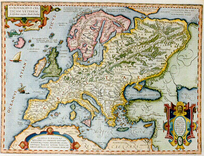
Title: EVROPAM, SIVE CEL:|TICAM VETEREM, | "sic describere conabar Abrah. Ortelius". [Europe, or Old Celtica was thus depicted in the efforts of Abraham Ortelius]. (Cartouche bottom right:) CVM | PRIVILE:|GIO DECEN|NALI, IMP. | REGIS ET | BRABANTI:|Æ CANCEL:|LARIÆ. | 1595 | PAX [With a ten year imperial, royal and Brabant council privilege, in peace, in 1595.] (Cartouche bottom left:) CLARISS. D. NICOLAO | ROCCOXIO I.V.L. PATRICIO ANTVERP. | EIVSDEMQ. VRBIS SENATORI, HANC | ANTIQVÆ EVROPÆ, NOVAM TABVLAM, | ABRAH. ORTELIVS DEVOTISSIME DEDICAB. [Abraham Ortelius has devotedly dedicated this new map of ancient Europe to the most famous lord Nicolaus Roccoxius, patrician of Antwerp and senator of that city]. (Top centre:) OCEANVS SEPTEM:|TRIONALIS QVI ET | HYPERBOREVS. | AMALCHIVM MARE "Hecatæo", | MORIMARVSA "a Cimbris vocatur". OCEANVS SARMATICVS "Plinio et Melæ", | SCYTHYCVS "Ptolemæo", | EVROBOREVS "Iornandi". [The Northern or Hyperborean ocean, called Amalchium sea by Hecatæus, and Morimarusa by the Cimbrians. Plinius and Mela call it Sarmaticus, Ptolemæus calls it Scyticus and Iornandes Euroboreus]. (Top centre:) "Insulæ complures sine nominibus, | Plinio 4. cap. 13". [Numerous islands without a name, Plinius Book 4, chapter 13.] (Top centre:) "Vmbilicus maris, de quo in nostro | Thesauro". [The navel of the sea, about which more in our Treasury]. (Top left:) "Insula quæ hacteus falsò Thule | credita fuit". [Island [located roughly on Iceland] which until now, but incorrectly is believed to be Thule]. (Upper left:) Fortunatæ insulæ, siue | Beatorum, quæ et Glessa:|riæ, item Electrides "Plinio". [The fortunate or happy islands, also called Glessaria and Electrides, says Plinius]. (Along the length of the Scandinavian peninsula:) "Sevo mons, Riphæis iugis asperitate minimè cedens". [A rough mountain ridge, hardly less harsh than the Ripheia ridge]. (Middle of Sweden:) NORTMANNI "a mediæ | ætatis scriptoribus hic | ponuntur". [The Norsemen, placed here by medieval authors]. (North Russia:) "Hyperborei montes hic Ptolemæi". [Here are the Hyperborean mountains, according to Ptolemæus]. (Upper right corner:) "Per huius fluvij ostium, | Caspium mare se exo:|nerare, existi:|mavit anti:|quitas". [In ancient times it was thought that through this river mouth the Caspian sea empties itself]. (Long diagonal line from SW to NE:) Her:cynia sil:ua tan:tæ longitudinis, ut qui dierum sexaginta iter processerit, ad eius initium minime peruenerit. [The Hercynian forest is of such length that whoever proceeds in it for sixty days, may hardly reach its beginnings].
Plate size: 357 x 476 mm.
Scale: 1 : 15,000,000
Identification number: Ort 189 (Koeman/Meurer: 26P, Karrow: 1/200, vdKrogtAN: 1000H:31).
Occurrence in Theatrum editions and page number:
1595L5Addblank (100 copies printed) (text and typesetting identical to 1595L, but without page number; last line, left aligned: gumento minus faciundo. Hanc Europam in Sacris litteris Iapetiam vocari, sunt qui opinentur.),
1595LB (500 copies printed) (text and typesetting identical to 1595L5Add, but here with page number B; last line, left aligned: gumento minus faciundo. Hanc Europam in Sacris litteris Iapetiam vocari, sunt qui opinentur.),
1597G5Addblank (75 copies printed) (identical with 1602G but here without page number; last line, left aligned, in Gothic script like the entire text: der heiliger schrifft Japetia gnant.),
1601Lviij (200 copies printed) (last line, left aligned: tales rege possideatur.),
1602G7 (250 copies printed) (identical with 1597G5Add, but here with page number 7; last line, left aligned, in Gothic script like the entire text: der heiliger schrifft Japetia gnant.),
1603Lviij (300 copies printed) (text and page number, but not typesetting, identical to 1609/1612L; last line, left aligned: summæ bonitatis: & dignam quæ à solo inter mortales rege possideatur.),
1606Eviij (300 copies printed) (last line, first text page, full width, mostly italic: "firme: nor in the" Electrides, "certaine fained ilands in the Hadriaticke sea, as some men of better credit, and more diligent searchers out of the truth,as" Pliny|"saith" ; last line second text page, left aligned, non-cursive: ty that any man but a king only should posesse.),
1608/1612Iviij (300 copies printed) (last line, left aligned: dettato vn lib. intero, essendo andato à bello studio per riconoscer le sue fontane personalmente , fauorito dall'hodierno Serenissimo Duca di Sauoia.),
1609/1612L/Sviij (300 copies printed) (text in Latin; last line, left aligned: dignam quæ à solo inter mortales rege possideatur.),
Bertius 16182QQ (100 copies printed) (some Bertius atlases have this Ortelius map, other copies have a successor, drawn by Evert Sijmonsz. Hamerveldt for Hondius, but all contain the text of the Theatrum 1609/1612L, reset).
1624LParergon/1641SLx (1025 copies printed) (text in two columns, last line, second column first text page: succinum siue electrum, quod Germani Glessum vocant. | at non ; last line second column second text page, left aligned: vocari, sunt qui opinentur.).
Approximate number of copies printed: 3450.
States: 189.1 only.
Cartographic sources: possibly derived to some extent from Ortelius' own two sheet map of the Roman empire, which appeared in 1571. Further, this map is based on classical sources, such as Sallustius, Plinius, Herodotus, Strabo and Dionysius.
References: P.H. Meurer "Ortelius as the Father of Historical Cartography", p. 133-159 in: M. van den Broecke, P. van der Krogt and P.H. Meurer (eds.) "Abraham Ortelius and the First Atlas", HES Publishers, 1998.
Remarks: Bertius bought a number of sheets with this map and included the map in his historical 1619 atlas "Theatrum Geographiæ Veteris".
The text below is very rich in bibliographical sources, discusses the [faulty] etymology of the word Europe at great length, and tries to prove beyond any doubt that what unites the Europeans is a common Celtic background.
For questions/comments concerning this page, please e-mail info@orteliusmaps.com.