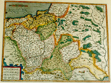
Cartographica Neerlandica Background for Ortelius Map No. 155

Title: POLONIAE, | LITHVANIĈQ. | DESCRIPTIO. | "Auctore Wenceslao Godreccio; et cor:|rectore Andrea Pograbio Pilsnensi". [A depiction of Poland and Lithuania by Wenceslav Godrecki, and corrected by Andreas Pograbius of Pilsen]. (Lower left:) "Cum priuilegio | Imp. Regiĉ etc. | decennali". [With imperial and royal privilege etc. for ten years] (Right centre:) "Picciari | specus. | nobilium Rus:|sorum sepultura". [The Picciari cave with the graves of high ranking Russians.] (Lower right:) PODOLIA, "pecore opi:|ma". [Podolia, rich with cattle.] (Lower right:) "Codima solitudo | uastissima". [Codima, a very vast desert.] (Upper right:) "Mellis et cerĉ | hic copia in:|gens". {Here is an enormous amount of honey and wax.]
Plate size: 373 x 487 mm
Scale: 1 : 2,500,000
Identification number: Ort 155 (Meurer:135/IV, not in Karrow, vdKrogtAN: 1900:31B).
Occurrence in Theatrum editions and page number:
1595L98 (500 copies printed) (last line, left aligned: bes eius etiam quĉdam scitu non indigna apud Chalcocondylam 2.),
1598F99 (525 copies printed) (last line, in cursive script like the entire text, left aligned: "Nous auons parlé du pays de Prusse en sa Carte particuliere".),
1598/1610/1613D68 (100 copies printed) (last line, not in Gothic script like the previous lines, left aligned: Reijn Reyneckius.),
1601L98 (200 copies printed) (last line, left aligned: à Reichersdorff. Habes eius etiam quĉdam scitu non indigna apud Chalcocondylam 2.),
1602G101 (250 copies printed) (last line, centred like 4 lines above it, in Gothic script like the entire text: gedruckt finde.),
1602S101 (250 copies printed) (last line, left aligned: nas degnas de saber en Calcocondilam.2.),
1603L101 (300 copies printed) (text, but not page number and typesetting, identical to 1609/1612L; last line, left aligned: Georgius à Reichendorff.Habes eius etiam quĉdam scitu non indigna apud Chalcocondylam 2.),
1606E98 (300 copies printed) (last line, left aligned: country.),
1608/1612I110 (300 copies printed) (last line, left aligned: la similmente si leggono alcune particolarita non indegne da sapersi nel 2. lib.),
1609/1612L111 (300 copies printed) (text, but not page number and typesetting, identical to 1603L; last line, left aligned: Georgius à Reichendorff.Habes eius etiam quĉdam scitu non indigna apud Chalcocondylam 2.),
1609/1612/1641S111 (325 copies printed) (last line, left aligned: de saber en Calcocondilam. 2.).
Approximate number of copies printed: 3350.
States: 155.1 as described.
155.2: in 1598 the name "Tarasoucze" is added to the blank town symbol on the river "Prut". Moreover, the double entry of "Tubarcza" on the lower Dnjestr has disappeared. The lower one has been replaced by "Maiak".
Cartographic sources: Grodecki 1558, 1562, and emendations by Pograbka, mostly on the right half of the plate, compared with plate 154. Grodecki's map itself is based on Wapovsky 1526 (Karrow 56/17, p. 280-281, Meurer p. 159, 216). See also Hessels nr. 91 in which the Pole Nikolaus Secovius complains about Ortelius' Poland map and recommends Pograbius, who had already been mentioned in the "Catalogus Auctorum".
Remarks: During 1595L this plate replaces Ort 154, which has the title POLONIAE | finitimarumque and which incurred two cracks in the lower right prohibiting further usage.
For questions/comments concerning this page, please e-mail info@orteliusmaps.com.