Cartographica Neerlandica Background for Ortelius Map No. 75
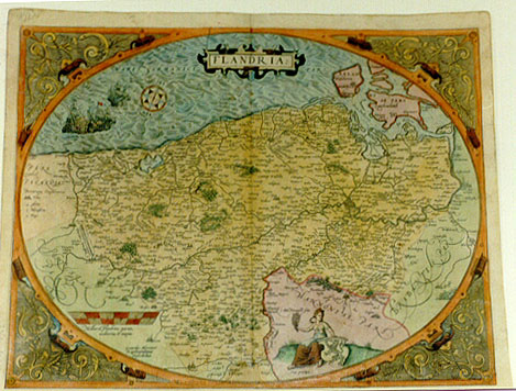
Title: FLANDRIA. (Lower left:) "Gerardus Mercator | Rupelmundanus | Describebat" [Flanders, which Gerardus Mercator has depicted.] (Lower right:) "Cum priuilegio." [With privilege].
Plate size: 387 x 503 mm
Scale: 1 : 400,000
Identification number: Ort 75 (Koeman/Meurer: 17, Karrow: 1/25, van der Krogt AN: 3200:31A)
Occurrence in Theatrum editions and page number:
1570L(AC)17 (225 copies printed) (last line, centred like two lines above it: doctissimè Iacobus Marchantius.),
1570L(B)17 (100 copies printed) (last line, centred like four lines above it: Iacobus Marchantius. ; F of title above Eu of Europe),
1571L17 (275 copies printed) (last line, centred like four lines above it: Iacobus Marchantius. ; F of title above E of Europe),
1571/1573D17 (350 copies printed) (last line, in Gothic script, centred like one line above it: gheaccordeert was/daer af gewijdt en zijns selfs gemaect.),
1572G17Koler (pasted over p.17 of a 1570L edition; few copies printed)(last line, left aligned, in Gothic script except for two names: trag gantz auffgehaben hat/widerumb für sich selbs und frey worden. Dises Land hat Ludouicus Guicciardinus sehr fleissig/Sehr künstlich aber Iacobus Marchantius beschrieben.),
1572/1573G17 (225 copies printed) (last line, centred like 3 lines above it: gethon) gefreyt,vnd sein selbst gemacht.),
1572/1574F17 (225 copies printed) (last line, centred like 2 lines above it: cord fait à Madril, entre sa Majesté & le Roy de France.),
1573L(AB)21 (75 copies printed) (last line, centred like 3 (version A) or 2 (version B) lines above it: chantius. Vide & Meyerum.),
1574L21 (175 copies printed) (large page number, 11 mm; title followed by a small round dot; 15th line from the bottom ends: oblon- ; last line, centred like the 7 lines above it: Tomos decem.),
1575L21 (100 copies printed) (small page number, 7 mm; title followed by a heavy diamond-shaped dot; 15th line from the bottom ends: oblon ; last line, centred like the 7 lines above it: Tomos decem.).
Approximate number of copies printed: 1750.
States: 75.0: an early state or rather non-state, only occurring in some 1570L edition of the Leiden University library has a heart-formed ornament immediately above the capital D in the cartouche. This is not a state, as I initially assumed, but it is a hole in the map that has been repaired, and the heart was drawn by the restorer, as was pointed out to me by Frans Gittenberger (personal communication). The facsimiles made of this atlas, viz. Elsevier-Sequoia Koeman 1964 and Rinsen Book Co., Tokyo of course also show this heart.
75.1: as described;
75.2: in the 1574 Latin edition the cylinder-like ornamental structures at the top of the lower left corner and at the bottom of the upper left corner have the hachuring on the right side leftwards extended: bottom ornament from 1 to 2 mm, top ornament from 2 to 3 mm.
Cartographic sources: Gerard Mercator's 1540 Flanders map (Karrow 56/6, p. 379-382, Meurer p. 196).
References: H.A.M. van der Heijden "Ortelius and the Netherlands", p. 271-290 in: M. van den Broecke, P. van der Krogt and P. Meurer (eds.) "Abraham Ortelius and the First Atlas", HES Publishers, 1998. E. Leenders: The map of Flanders by Gerard Mercator and Jacob van Deventer. "Brussels International Map Collectors' Circle" no. 30, p. 18-23, 2008.
Remarks: According to some, Mercator drew and engraved this map himself.
This map is followed by plate Ort 76. These two maps are very similar, but on the present plate 75 compass directions are not mentioned in the corners, whereas they are on the later plate 76. The lady at the bottom does not wear a hat on Ort75 but wears a pointed hat on Ort76. Texts of Ort75, Ort76 and Ort77 are very similar.
Note that the topmost ship also occurs on the Angliae, Scotiae et Hiberniae map (Ort16) and the Germania map (Ort56).
For questions/comments concerning this page, please e-mail info@orteliusmaps.com.