Cartographica Neerlandica Background for Ortelius Map No. 76
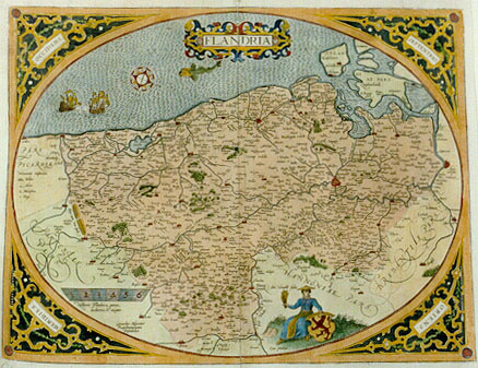
Title: FLANDRIA (Lower left near edge oval shape:) "Gerardus Mercator | Rupelmundanus | Describebat." [Flanders, which Gerardus Mercator from Rupelmonde has depicted] (Below figure:) "Cum priuilegio" [With privilege].
Plate size: 380 x 493 mm
Scale: 1 : 400,000
Identification number: Ort 76 (Koeman/Meurer: 93/II; not in Karrow, van der Krogt AN: 3200:31B)
Occurrence in Theatrum editions and page number:
1579L(A)32 (250 copies printed)(last line, centred like 2 lines above it: Iacobi Meyeri Flandicarum rerum Tomos decem.),
1579L(B)32 (250 copies printed)(last line, centred like 2 lines above it: Meyeri Flandicarum rerum Tomos decem.),
1580/1589G32 (350 copies printed) (last line, centred like 5 lines above it, in Gothic script like the entire text: Flandern.),
1581F32 (400 copies printed) (last line, left aligned: soymesme,par l'accord fait à Madril,entre sa Maiesté & le Roy de France.),
1584L38 (750 copies printed) (last line, centred like two lines above it: Meyeri Flandricarum rerum Tomos decem.),
1587F38 (250 copies printed) (last line, left aligned: sté & le Roy de France.),
1588S38 (300 copies printed) (last line, centred like 4 lines above it: de Iacobo Meyero.),
some 1592L40 (125 copies printed?),
1603 (Vrients1) has no text or page number.
Approximate number of copies printed: 2675.
States: 76.1 as described
76.2: the right ship of the two received additional hachuring on the lower part of the left and middle main sail after 1581 and before 1584;
76.3: A copy of this map occurs on which there has been added between the bottom of the oval shape and the straight line edge: "Theodorus Galle excud. Antuerpiæ". Probably, this was done after 1612 and indicates that plate Ort76 was intended for re-use at this time.
Cartographic sources: Gerard Mercator's 1540 Flanders map (Karrow 56/6, p. 379-382, Meurer p. 196).
References: H.A.M. van der Heijden "Ortelius and the Netherlands", p. 271-290 in: M. van den Broecke, P. van der Krogt and P. Meurer (eds.) "Abraham Ortelius and the First Atlas", HES Publishers, 1998. E. Leenders: The map of Flanders by Gerard Mercator and Jacob van Deventer. "Brussels International Map Collectors' Circle" no. 30, p. 18-23, 2008.
Remarks: This map succeeds plate Ort 75. It is very similar, but compass directions are now mentioned in the corners, which is not the case on the earlier plate 75, and the lady in the foreground now has a pointed hat. This plate is succeeded in 1592 by plate Ort 77, which is no longer oval-shaped, and which has an inset.
For questions/comments concerning this page, please e-mail info@orteliusmaps.com.