Cartographica Neerlandica Background for Ortelius Map No. 48
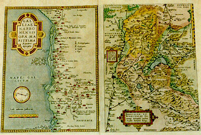
Title: GAL|LIĆ | NARBO|NENSIS | ORA MA|RITTIMA "Recenter | descripta". [A recent depiction of Narbonne in France, harbour at the sea]. (Upper right:) "Cum Priuilegio." [With Privilege]. Latin text of 6 lines in sea: "Maquelone domus | est cum templo Episcopi | Mons peßehensis, olim sedes | episcopalis eiusdem: et dice:|batur Episcopatus Magalonen:|sis. In medijs stagnis situ est". [In Maguelon you find the house and church of the bishop of Monspesse, formerly see of the same bishop, called the bishopric of Magalon. It lies amidst pools]. (Upper right:) "Sylva est ex tamariscis: | locus latronibus infestus". [This wood consists of tamarind trees; it is a place infested by crooks.] (Lower right:) "Vaucluse, locus ubi Petrarcha | magnam partem carminum | italicorum composuit". [Vaucluse, the place where Petrarca composed a large part of his Italian verses.] (Mid bottom:) "Tour d'y insula | ubi Brutus stationem nauiű | habuit cum Maßilia a C. Iulio obsideretur". [Tour, the island where Brutus had his fleet together with Marseille, where he was besieged by Iulius Cćsar.] - SABAVDIĆ, ET | BVRGVNDIĆ Co:|mitatus descriptio; auctore | Ćgidio Bulonio Belga. [A representation of the dukedom of Savoye and Burgundy by Ćgidius Bulonius the Belgian]. [Cartouche with 7 lines of Latin text middle right]: Huius fluuy: | oram citerio:|rem,Regni: vl:|teriorem vero | Impery cogno:|mine, apelli:|tant accole. [Those living in this area call this side of the river "Of the Kingdom", the other side of the river "Of the Empire"].
Plate size: 303 x 447 mm. Two maps on one plate.
Identification number: Ort 48.
Title 48a: Narbonensis. West at the top.
Scale: 1 : 700,000. Size: 303 x 223 mm.
Identification number: Ort 48a (Koeman Meurer: 12a, Karrow 1/19, van der Krogt AN: 4652:31A).
States: 48a.1 only.
Cartographic sources: Carolus Clusius or Charles de l'Escluse (1526-1609) was invited by Ortelius to make a hand-drawn map (which turned out not to be very accurate), of the Southern French coast (Meurer p. 128, Karrow 59/5 p. 438). Perhaps to reduce its significance, it later appeared as plate 49a on a much smaller scale.
Title 48b: Sabaudić et Burgundić
Scale: 1 : 1,500,000. Size: 303 x 213 mm.
Identification number: Ort 48b (Koeman/Meurer: 12b, Karrow: 1/20, van der Krogt AN: 4760:31A).
States: 48b.1 only.
Cartographic sources: Gilles Boileau de Bouillon (1510-1563) made a two-sheet map of Savoye which was published by Hieronymus Cock in 1556 (Karrow 12/20, p. 85-86, Meurer p. 116).
Occurrence in Theatrum editions and page number:
1570L(AC)12 (225 copies printed) (last line, centred like 4 lines above it: non Robertum Cnalem. Last word of fifth text line from the top: Rho-),
1570L(B)12 (100 copies printed) (last line, centred like 4 lines above it: non Robertum Cnalem. Last word of fifth text line from the top: lacum),
1571L12 (275 copies printed) (last line, centred like 4 lines above it: non Robertum Cnalem. Last word fifth text line from the top: lacum,),
1571/1573D12 (350 copies printed) (last line, centred like two lines above it: Tarantaise, Moustiers, Montbelial,etc.),
1572G12 (pasted over p.12 of a 1570L edition; few copies printed)(last line, left aligned, in Gothic script except for the last two names: Nozoreno, sonderlich beschrieben/ Besihe auch Paradinum und Robertum Cnalem.),
1572/1573G12 (225 copies printed) (last line, cursive like the entire Burgundy and Savoye text, centred like one line above it: "Tarantaise,Moustiers,vnd Montbelial,etc."),
1572/1574F12 (225 copies printed) (last line, centred like 5 lines above it, in cursive script like the entire text: "Moustiers,& Monbelial,&c".),
1573L16 (75 copies printed) (Version A: last line, centred like 2 lines above it, last 11 lines in smaller font than the rest. last line, centred like 2 lines above it, in cursive script: "Fabula sit ne, an historia , fides eius apud auctorem".); In version B, last line, centred like two lines above it, in non-cursive script: Fabula sit ne, an historia , fides eius apud auctorem. Third line from the bottom ends: vulgň);
1574L16 (175 copies printed) (large page number, 11 mm; last line, cursive unlike the entire Ort48A text but like the second half of the Ort48B text, centred like 4 lines above it: "tiarum nominari , inter Narbonensis Gallić prouincias."),
1575L16 (100 copies printed) (small page number, 7 mm, last line, cursive like the entire Ort48A and the second half of the Ort48B text, centred like 5 lines above it: "tiarum nominari,inter Narbonensis Gallić prouincias".),
1579L(A)22 (250 copies printed) (last line: left aligned: pore Augusti Imperatoris. ; second line from the bottom ends: auctores,tem-),
1579L(B)22 (250 copies printed) (last line: left aligned: pore Augusti Imperatoris. ; second line from the bottom ends: auctores;tem-),
1580/some 1589G22 (300 copies printed) (last line, centred like 3 lines above it, in Gothic script: hat/haben auch vil Scribenten gemeldet:zur zeit des Keysers Augusti.),
1581F22 (400 copies printed) (last line, left aligned, in cursive script like the entire text: "nibal un Royaume, ainsi qu'on peut lire en Tite Liue & en I. Flores.").
Approximate number of copies printed: 2950.
Remarks: Replaced from 1584L3Add onwards by plate Ort 49, where these two maps each obtain a quarter page, and are coupled to Venaissin.
For questions/comments concerning this page, please e-mail info@orteliusmaps.com.