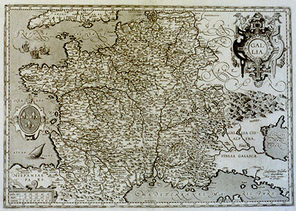
Cartographica Neerlandica Background for Ortelius Map No. 35

Title: GALLIA [France] (lower right corner:) "Guilielmus Postellus | describebat. | Abrah. Ortelius excudebat, | cum priuilegio." [Guillaume Postel drew [this map], Abraham Ortelius published it, with privilege].
Plate size: 346 x 497 mm
Scale: 1 : 3,900,000
Identification number: Ort 35 (Meurer: 135/III, not in Karrow, van der Krogt AN: 4000:31B).
Occurrence in Theatrum editions and page number: never regularly included.
Approximate number of copies printed: very few. Five or six copies have survived.
States: 35.0 a copy of this map exists without the dotted lines indicating province an country borders, most probably a proof state;
35.1 as described.
Cartographic sources: Guillaume Postel (1510-1581) made a map of France which was printed from two wood blocks in Paris in 1570. This map was an improvement on the Jolivet source, which is the standard map through most editions of the Theatrum (plate Ort34). The present map is a reduced but true copy of Postel's map.
Remarks: DenucÚ mentions a 1598D edition (Plantin Museum, sign. A760) which contains this map. The copy described and shown by Meurer (p. 219, Figure 55) has no text on verso, and the same applies to my copies and to Stopp's copy of this map. I noticed a 1588S edition at Reiss Auctions spring 2005 which contained a copy of this map, but with the Spanish text normally given to Ort34. Apparently, it was sold for a limited time as a separate single sheet map. Also, a copy of the 1613 Dutch edition in the University Library of Amsterdam has the standard text usually found on Ort34.
As pointed out by Gittenberger (personal communication), the cartouche of this map is a close copy of Mercator's Zelandia map.
A fairly close copy of this map, but without hatching of the coat of arms, was included in Bouguereau 1594.
For questions/comments concerning this page, please e-mail info@orteliusmaps.com.