Cartographica Neerlandica Background for Ortelius Map No. 34
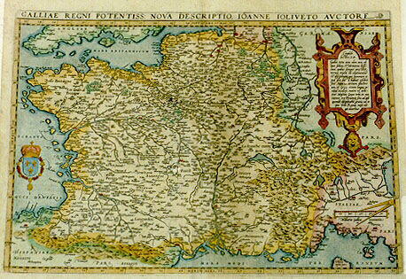
Title: GALLIAE REGNI POTENTISS: NOVA DESCRIPTIO. IOANNE IOLIVETO AVCTORE [A new description of Gallia, a most powerful kingdom, by Iohannes Iolivetus] (middle right:) "Cum priuilegio". [With privilege] (Upper right cartouche with 16 lines of text:) "Candido | Lectori S.D. | ... qui doceretur". [Studious reader, be greeted. Entire Gallia was in earlier times not only famous for its riches and military courage, in which they are still prominent, but also for their self-restraint and their learning, which attained a prominence among them. For it also excelled in the knowledge of famous arts, and even in the Greek language, I think because Massilia, which lies at the sea coast, had a Greek city as its mother; once even students from Rome itself were sent here to obtain an education] (Middle left below Nantes:) "Talimont, dit | talon du mőde" [Talimont, also called the heel of the world]. (Middle left:) "Vlmus hćc quator collatera:|lium prouinciarum fines | attingit" [Here stands an elm where the borders of four provinces touch each other.]
Plate size: 351 x 507 mm
Scale: 1 : 3,900,000
Identification number: Ort 34 (Koeman/Meurer 9, K: 1/14, van der Krogt AN: 4000:31A).
Occurrence in Theatrum editions and page number:
1570L(A)9 (100 copies printed) (last line, centred like 7 lines above it: ŕ Knobelsdorf.),
1570L(B)9 (100 copies printed) (last line, centred like one line above it: Lutetiam ... Knobelsdorf.),
1570L(C)9 (125 copies printed) (last line, centred like 5 lines above it: Eusthatius ŕ Knobelsdorf.),
1571L9 (275 copies printed) (last line, centred like 5 lines above it: Eustathius ŕ Knobelsdorf.),
1571D/1573D9 (350 copies printed) (last line, in cursive script, centred like two lines above it: "ende een geswil is als een cliere,dat ter syden aenden hals comt".),
1572/1574F9 (225 copies printed) (last line, centred like 2 lines above it: ne bosse comme vne glande,qui leur vient de costé du col.),
1572G9(Koler) (pasted over p.9 of a 1570L edition; few copies printed)(last line, in Gothic script except for last name, left aligned: hat Eustathius von Knobelsdorff Carminicć oder Vers weise beschriben.),
1572/1573G9 (225 copies printed) (last line, cursive like the entire text, centred like two lines above it: "hand dar an greifft oder rhurt, hailet".),
1573L13 (75 copies printed) (Version A has 22nd line from the bottom ending with: ŕ Ga- ; Version B has 22nd line from the bottom ending with: Oceanum ; both versions have as their last line, centred like 6 (version A) or 7 (version B)lines above it: pierius verň Lugdunum.),
1574L13 (175 copies printed) (large page number, 11 mm; last line, centred like one line above it: siorű descripsit carmine Eusthatius ŕ Knobelsdorf,Champierus verň Lugdunum.),
1575L13 (100 copies printed) (small page number, 7 mm, last line centred like two lines above it, in cursive script like the entire text: "Eustathius ŕ Knobelsdorf; Champierius verň Lugdunum".),
1579L(A)16 (250 copies printed) (last line, centred like two lines above it, in cursive script like the entire text: "ŕ Knobelsdorf ; Champierus verň Lugdunum".),
1579L(B)16 (250 copies printed) (last line, left aligned, in cursive script like the entire text: "Parisiorum descripsit carmine Eusthatius ŕ Knobelsdorf;Champierus verň Lugdunum".),
1580/1589G16 (350 copies printed) (last line, centred like 4 lines above it, in Gothic script: beschriben.),
1581F16 (400 copies printed) (last line, left aligned: vne glande,qui leur vient de costé du col.),
1584L20 (750 copies printed) (last line, centred like 2 lines above it, in italic script like the entire text: "ŕ Knobelsdorf; Champierius verň Lugdunum."),
1587F20 (250 copies printed) (last line, left aligned: vne glande , qui leur vient de costé du col.),
1588S20 (300 copies printed) (last line, centred like 3 lines above it: a Paris en verso ; y Champierio a Lugduno.),
1592L21 (525 copies printed) (last line, in cursive script like the entire text, left aligned: "carmine Eustathius ŕ Knobelsdorf ; Champierus verň Lugdunum".),
1595L21 (500 copies printed) (last line, left-aligned: verň Lugdunum.),
1598D19 (50 copies printed) (last line, centred like 2 lines above it, italic script like the entire text: "ende een gesvvil is als een cliere,dat ter zyden aenden hals comt".),
1598F21 (525 copies printed) (last line, left aligned: vne glande, qui leur vient de costé du col.),
1601L21 (200 copies printed) (12th line from the bottom ends: Alterum, ; last line, left aligned: pierus verň Lugdunum.),
1602S21 (250 copies printed) (last line, left aligned: declarado a Paris en verso; y Champiero a Lugduno.),
1602G21 (250 copies printed), no data,
1603L21 (300 copies printed) (12th line from the bottom ends: Alterum,quňd ; last line, left aligned: pierus verň Lugdunum.),
1606E21 (300 copies printed) (last line, left aligned: ty of "Paris" is described in verse by "Eusthatius ŕ Knobeldorf"; and the city of "Lions" by "Champier".).
Approximate number of copies printed: 5925.
States: 34.1 as described;
34.2 between 1584 and 1587 a crack developed just above the degree number 42 in the lower left corner. This crack widened progressively in time. At the same time, the hachuring at the coast and around islands was extended from about 3 to about 6 mm.
34.3 "Ponteau de | mer" on the left bank of the mouth of the river Seine was re-engraved in smaller lettering as "Ponteau de | mer" and to the right of it, the village of "Qual:|beuf" was added; the place name "Lucerne" in the Italian alps was re-engraved and the river on which it is located acquires a new fork and the name "Saluße"; this happened after 1601L and before 1602S.
Cartographic sources: Jean Jolivet made a four-sheet woodcut map of France which went through various editions from 1560 onwards, and which was often copied, also here (Meurer p. 176-177, Karrow 44/5 p. 322-323). Next to Jolivet, Ortelius mentions 7 other authors who made maps of France, namely Orontius Finćus Delphinas, Nicolaus Germanus, Cornelius a Judćus' (de Jode) 1592 map of France, Nicolaus Nicolaius Delphinas, Petrus Plancius of Amsterdam, Postellus' 1572 map of France (see Ort 35) and Andreas Thevetus' map of 1578.
Remarks: From 1608/1612I this map was succeeded by Vrients' plate Ort 36. Postel's map of France, see plate Ort 35 was never regularly included in the Theatrum.
For questions/comments concerning this page, please e-mail info@orteliusmaps.com.