Cartographica Neerlandica Background for Ortelius Map No. 36

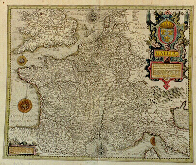
Title: GALLIA | Geographica Galliĉ descriptio, de integro | plurimis in locis emendata ac Regionum | limitibus distincta; auctore Petro Plantio. | "Quicquid terrarum Rheno, Alpibus, mari Mediterraneo, Pyre: | nĉis montibus, oceano Aquitanico Brittanico et Germanico, | clauditur; communi nomine Latinis Gallia appellatur: quibus limi: | tibus potentissimum Francorum regnum, Sabaudiĉ, Burgundiĉ | comitatus, Helvetia, Alsatia, Lotharingia, inferior Germania, | et quĉdam aliĉ regionis hodie continentur. | Ioannes Bap: | tista Vrints | excudit" [A geographical depiction of France, entirely improved in many places and distinguished by the borders of its regions; by Petrus Plancius, the lands of which are defined by the Rhine, the Alps, the Pyrenee mountains, and the Mediterranean, British and German oceans, called with its general Latin name Gallia; The present borders of this mighty kingdom of the French are Sabaudia, Burgundy, Helvetia, Alsatia, Lotharingia, Lower Germany and some other regions. Made by Ioannes Baptista Vrients].
Plate size: 401 x 486 mm.
Scale: 1 : 3,900,000
Identification number: Ort 36 (Koeman/Meurer: 150, not in Karrow; van der Krogt AN: 4000:31C).
Occurrence in Theatrum editions and page number:
1606Exliiij (300 copies printed) (last line, left aligned: tuled, The view of France.),
1608/1612I24 (300 copies printed) (last line, left aligned: racoli dell'acque & delle fonti. Eustatio Knobelsdorf descrisse la citta di Parigi in versi; & il Camperio Leone.),
1609/1612/1641S23 (325 copies printed) (last line, full width: de sus aguas y fuentes.Eusthatio de Knobelsdorf ha declarado a Paris en verso;y Champierio a Lugduno.),
1609/1612L23 (300 copies printed) (last line, left aligned: pierius verò Lugdunum.).
Approximate number of copies printed: 1225.
States: 36.1 has "Ioannes Bap: | tista Vrints | excudit", in the bottom of the cartouche.
36.2: after 1612S this is changed to "Theodor. Gallĉus | excudebat | Antverpiĉ.
Cartographic sources: Petrus Plancius (1552-1622) made a map of France, engraved by the van Deutecums, and published by Vrients in 1592. That map is closely followed on the present plate (Meurer p. 215).
For questions/comments concerning this page, please e-mail info@orteliusmaps.com.