Cartographica Neerlandica Background for Ortelius Map No. 31
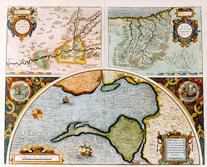
Title: "Cum priuilegio Imp. et| Belgico, ad decennium". CAR:|PETANI:|Ć PARTIS | DESCR. | "1584" - "Vardulorum, sive" | GVI:|PVSCOAE | REGIONIS | TYPVS. - [Cadiz Vrbs] HANC INSVLAM | PERLVSTRABAT, | ET SVA MANV DE:|PINGAT GEOR:|GIVS HOEFNAGLI:|VS ANTVERPIAN. | BELGA. | "Dum extendar". [With an Imperial and Belgian Privilege for ten years. Depiction of a part of Carpetani 1584 - A Map of the Varduli or the region of Guipuscoa - The City of Cadiz. This island has been explored and drawn in his own hand by Georgius Hoefnaglius of Antwerp, Belgium, as it presents itself.] (Top left:) "Glycerisć maximus | hic proventus" [Here is a great supply of glycerine.] Top left: "Leganes. Separum | hic magnus | prouentus". [Leganes. Here are many hedges.] (Top left:) "Torejon. | Salsamentorum pis:|cium emporium". [Torejon, a market for salted fish.] (Top left:) Esqujvias|nobiliß.hinc|vinum. [Esqujvias. The wine from here is excellent.] (Top left:) "La mar. pis:|cina est". [La mar. This is a swimming pool.] (Top left centre:) "Hic multa antiqua | monumenta effodiuntur". [Here many ancient monuments are dug up.] (Lower left centre:) "Hic olim fuiße | vrbem, indicant|ruinć ingentes". [Here was once a city, as extensive ruins indicate.] (Centre:) "Ocańa. Olcades hic olim habitas:|se credit Nebrißensis". [Ocańa. Here lived the Olcades once, as Nebrißensis believes.] (Centre:) "Puntal. Hic saburram exonerant | naues sal recepturć". [Puntal. Here ships ballasted with sand load salt.] (Bottom centre:) "Nobilißima Hispanić | vina hic nascuntur". [Here grow the most noble wines of Spain.] (Bottom centre:) "Torres de | Hercules: Almedraua. Hic thynno:|rum captura a Calendis | Maij ad XVII. vsque|Calend. Iulij". [Almedrava near the pillars of Hercules. Here they catch tuna fish from the 17th of May until the beginning of July].
Plate size: 392 x 488 mm. For sizes of each map, see below. Three maps on one plate.
Identification: Ort31 (Koeman 99a-c, Karrow 1/138-1/140)
Title 31a: Carpetanić
Scale: 1 : 250,000. Size: 174 x 237 mm
Identification number: Ort 31a Koeman/Meurer: 99a, Karrow: 1/138, van der Krogt AN: 6058:31)
States: 31a.1 as described.
31a.2: after 1612, the date was replaced by a horizontal line.
Cartographic sources: very accurate source of unknown nature. The names of Carolus Clusius and Georg Hoefnagel have been suggested (Meurer p. 89).
Title 31b: Guipuscoć
Scale: 1 : 300,000. Size: 173 x 233 mm
Identification number: Ort 31b (Koeman/Meurer: 99b, Karrow: 1/139, van der Krogt AN: 6020:31)
States: 31b.1 only.
Cartographic sources: the source of this map, which was also published by de Jode in 1578, is unknown (Meurer p. 92).
Title 31c: Cadiz
Scale: 1 : 100,000. Size: 231 x 485 mm
Identification number: Ort 31c (Koeman/Meurer: 99c, Karrow: 1/140, van der Krogt AN: 6115:31)
States: 31c.1 as described.
Cartographic sources: Georg Hoefnagel, who drew a manuscript map during his stay in Spain from 1563 to 1567 (Meurer p. 167-168).
Occurrence in Theatrum editions and page number:
1584L3Addblank (100 copies printed) (identical with 1584L, but here without page number; last line, left aligned: niam non profert hćc tabula,sed partem tantům ; quć ŕ Toleto versus Orientem vergit.),
1584G3Add19 in upper right corner (75 copies printed) (last line, left aligned, in Gothic script like most of the text: von Telodo gegen auffganck lenckt.),
1585F3Add10 (75 copies printed) (last line, left aligned: qui tire de Tolede vers le Soleil leuant.),
1584L19 (750 copies printed) (identical with 1584L3Add, but here with page number; last line, left aligned: niam non profert hćc tabula,sed partem tantům ; quć ŕ Toleto versus Orientem vergit.),
1587F19 (250 copies printed) (last line, left aligned: Tolede vers le Soleil leuant.),
1588S19 (300 copies printed) (last line first text page, right aligned: ella ; last line second text page, left aligned: va de Toledo hazia el Leuante.),
1592L20 (525 copies printed) (4th line from the bottom ends: Stra- ; last line, left aligned: tabula, sed partem tantům,quć ŕ Toleto versus Orientem vergit.),
1595L20 (500 copies printed) (4th line from the bottom ends: nouit ; last line, left aligned: tabula,sed partem tantům,quć ŕ Toleto versus Orientem vergit.),
1598/1610/1613D18 (100 copies printed) (last line, left aligned, in Gothic script: deel dat van "Toleto" naer het Oosten toe leyt.),
1598F20 (525 copies printed) (last line, left aligned: Tolede vers le Soleil leuant.),
1601L20 (200 copies printed) (last line, left aligned: ctus Rogerus circa annum millesimum ducentesimum.),
1602G20 (250 copies printed) (last line, in Gothic script like the entire text, left aligned: sonder nur ein theyl/welches sich von Telodo gegen auffganck lenge.),
1602S20 (250 copies printed) (last line, first text page, right aligned: GVI-; last line second text page, left aligned: ganos. viuio este dicho Rogero cerca al ańo de mil doscientos.),
1603L20 (300 copies printed) (last line, left aligned: Vixit hic dictu, Rogerus circa annum millesium ducentesimum.),
1606E20 (300 copies printed) (last line, left aligned: fold, to wash mens heads, and their apparell,aswell Christians as Pagans. The said "Roger" liued about the yeere 1200.),
1608/1612I17 (300 copies printed) (last line, left aligned: stra Redentione 1200.),
1609/1612/1641S17 (325 copies printed) (last line first text page, right aligned: lestas, ; last line second text page, left aligned: stianos, como de paganos. viuio este dicho Rogero cerca al ańo de mil doscientos.),
1609/1612L17 (300 copies printed) (last line, left aligned: ca annum millesimum ducentesimum.).
Approximate number of copies printed: 5425.
References: A. Hernando "The contribution of Ortelius' Theatrum to the Geographical Knowledge of Spain. p. 239-262 in Van den Broecke, van der Krogt & Meurer (eds.) "Abraham Ortelius and the First Atlas, 1998, HES Publishers.
For questions/comments concerning this page, please e-mail info@orteliusmaps.com.