Cartographica Neerlandica Background for Ortelius Map No. 30
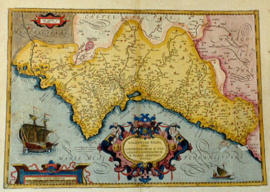
Title: VALENTIAE REGNI,|olim/CONTESTANORVM SI PTO:|LEMAEO, EDETANORVM|SI PLINIO CREDIMVS|TYPVS. [Map of the kingdom of Valencia, once called Contestani if we may believe Ptolemćus or Edetani if we may believe Plinius] (cartouche upper left:) "Cum priuilegio ad decen:/nium 1584". [With a privilege for ten years. 1584]. (Upper right:) "Limes vetus inter Valentiam et Arragoniam. Limes nouus inter Valentiam et Arragoniam". [The old/new border between Valencia and Arragonia.]
Plate size: 350 x 494 mm
Scale: 1 : 700,000
Identification number: Ort 30 (Koeman/Meurer: 107, Karrow: 1/137, van der Krogt AN 6155:31B)
Occurrence in Theatrum editions and page number:
some 1587F18 (50 copies printed?),
some 1588S18 (50 copies printed?),
some 1592L19 (250 copies printed?),
1595L19 (500 copies printed) (last line, left-aligned: Furio Cćriolano Valentino accepi.),
1598F19 (525 copies printed) (last line, left aligned: re & Ambroise Morale.),
1601L19 (200 copies printed) (5th line from the bottom ends: Beu- ; last line, left aligned: Cćriolano Valentino accepi.),
1602G19 (250 copies printed) (in Gothic script like the entire text, left aligned: gen tag/sintemal der König sampt der Inquisition durch diefinger sehen.),
1602S18 (250 copies printed) (last line, left aligned: manera de viuir de sus padres y aueulos.),
1603L19 (300 copies printed) (last line, left aligned, in italic script ilke the entire text: "Cćriolano Valentino accepi".),
1606E19 (300 copies printed) (last line, italic like the entire text, left aligned: "most worthie and famous man" Frederick Furius Cćriolanus "naturrall of" Valentia.),
1608I/1612I22 (300 copies printed) (last line, left aligned: derico Furio Valentiano, huomo chiarissimo.),
1609S/1612/1641S21 (325 copies printed) (last line, left aligned: dia tienen la lengua y manera de viuir de sus padres y aueulos.),
1609L/1612L21 (300 copies printed) (5th line from the bottom ends: inscriptionibus ; last line, left aligned: Cćriolano Valentino accepi.).
Approximate number of copies printed: about 3500
States: 30.1 only.
Cartographic sources: unidentified (Meurer p. 96). Brandmair suggests Furius Cćriolanus as a possible source, see also Hessels nr. 173, where Arias Montanus provides information to Ortelius on Cćriolanus.
References: A. Hernando "The contribution of Ortelius' Theatrum to the Geographical Knowledge of Spain. p. 239-262 in Van den Broecke, van der Krogt & Meurer (eds.) "Abraham Ortelius and the First Atlas, 1998, HES Publishers. Roselló, V.M. (2000) Jeroni Munyós i la primera trangulació valenciana (per A. Oertel?), Cuadernos de Geografía, Valencia, Facultat de Geografia i Histňria, Universidad de Valencia 67/68 pp. 137 Based on a manuscript of 1568 (using survey methods of Gemma Frisius) in Bib. Apost. Vat., MS. VL 6998, suggests that the results were a source for Ortelius' Valentiae Regni map.
Remarks: regular successor of the rare plate Ort 29, which is very similar, but which has straight rather than the present cursive capitals for "MARIS|MEDITERRANEI PARS" at the bottom in the sea area, and shows a lower quality of engraving than the present one.
For questions/comments concerning this page, please e-mail info@orteliusmaps.com.