Cartographica Neerlandica Background for Ortelius Map No. 92

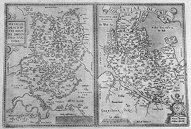
Title: HASSIAE DESCRIP:|TIO, IOAN:|NE DRYAN:|DRO AVC:|TORE .1579.| (Left top:) "Cum gratia, &|Priuilegio.decen." [Depiction of Hessen by Iohannes Dryander .1579.] - HOLSATIAE DESCRIP. [A depiction of Holstein] (Cartouche lower right corner:) "Cum gratia et Privile:|gio.|Marcus Iordanus|Holsatus describeb". [With grace and Privilege, depicted by Iordanus from Holstein].
Plate size: 336 x 492 mm. Two maps on one plate.
Identification number: Ort 92.
Title 92a: HASSIAE
Scale: 1 : 900,000. Size: 336 x 243 mm.
Identification number: Ort 92a (Koeman/Meurer: 86a, Karrow: 1/121, van der Krogt AN: 2450:31A).
States: 92a.1 as described.
92a.2: between 1592 and 1598, the rivers Main and Rhine received additional engraved lines; the ornaments around the title cartouche, viz. cylinders and balls, have now been filled with additional lines.
Cartographic sources: a manuscript map by Johannes Dryander (Meurer p. 140).
Title 92b: HOLSATIAE DESCRIP.
Scale: 1 : 900,000. Size: 336 x 245 mm.
Identification number: Ort 92b (Koeman/Meurer: 86b, Karrow: 1/122, van der Krogt AN: 1660:31A).
States: 92b.1 as described.
92b.2: after 1589 and before 1592 the following placenames were added Northwest of the region Stormare: "Quinckborn, Berchstede, Winsen" & "Tremsebutte".
92b.3: between 1592 and 1598, the hachuring on the coastlines and the banks of the river Elbe was extended from about 3 mm to about 7 mm. The left side of the privilege cartouche now has crosshatching not only at the upper part, but everywhere.
Cartographic sources: Mark Jorden or Marcus Jordanus, who drew a map of Holstein which was published in 1559 by Joachim Loew in Hamburg (Karrow 45/3, Meurer p. 178-179).
Occurrence in Theatrum editions and page number:
1579/1580L28a (250 copies printed) (5th line from the bottom ends: hunc ; last line, left aligned: bes non habet. villis namque tant¨m & pagis habitantur.& de ea suprÓ suo loco diximus.),
1579L(A)43 (250 copies printed) (5th line from the bottom ends: hunc ; last line, left aligned: bes non habet. villis namque tant¨m & pagis habitantur.& de ea suprÓ suo loco diximus.),
1579L(B)43 (250 copies printed) (5th line from the bottom ends: popu- ; last line, left aligned: bes non habet.villis namque tant¨m & pagis habitantur.& de ea suprÓ suo loco diximus.),
1580G2Add28A (50 copies printed), (last line, left aligned, in Gothic script: ist nur mit H÷fen und D÷rffern bewohnt. Von derselbigen haben wir auch droben an ihrem besonderen ort gesagt.),
1580/1589G43 (350 copies printed) (last line, left aligned, in Gothic script: ist nur mit H÷fen und D÷rffern bewohnt. Von derselbigen haben wir auch droben an ihrem besonderen ort gesagt.),
1581F43 (400 copies printed) (tion cy dessus en son lieu.),
1584L49 (750 copies printed) (last line, left aligned: bes non habet.villis namque tant¨m & pagis habitatur.& de ea suprÓ suo loco diximus.),
1587F49 (250 copies printed) (last line, left aligned: dessus en son lieu.),
1588S49 (300 copies printed) (last line, left aligned: su lugar.),
1592L51 (525 copies printed) (last line, left aligned: sia vrbes non habet: villis namque tant¨m & pagis habitatur. & de ea suprÓ suo loco diximus.),
1598F56 (525 copies printed) (last line, left aligned: dessus en son lieu.).
1602G56 or 28a (250 copies printed) (last line, left aligned, in Gothic script like the entire text: ist nur mit H÷fen und D÷rffern bewohnt. Von derselbigen haben wir auch droben an ihrem besondern ort gesagt.).
Approximate number of copies printed: 4150.
Remarks: In 1595L, Ort 92a Hassia was replaced by the very similar plate Ort 95b (but with MOGVNTINENSVS | DIOCESVS in lower left in straight capitals whereas on this plate Ort 92 in cursive capitals). Ort 92b Holsatia was replaced by plate Ort 87a (with map name in lower left, whereas on this plate Ort 92b on banner across top). Some overruns of this sheet were used in 1602G with page number 56.
For questions/comments concerning this page, please e-mail info@orteliusmaps.com.