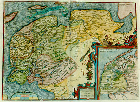
Cartographica Neerlandica Background for Ortelius Map No. 81

Title: FRISIA OCCIDENTALIS. [West Friesland]. (Cartouche lower centre:) SIBRANDVS LEONIS | LEOVARDIENSIS | DESCRIB. | "Cum priuilegio Imp. et Reg. | Mtm. ad decennium .1579." [Depicted by Sibrandus Leo of Leeuwarden, with Imperial and Royal privilege for ten years. 1579.](Inset:) Antiquae FrisiŠ situs sub Augusto | Imperatore, ut fertur. [The seat of ancient Frisia under emperor Augustus, as has been supposed].
Plate size: 368 x 498 mm; inset in lower right: 202 x 160 mm.
Scale: 1 : 300,000
Identification number: Ort 81 (Koeman/Meurer: 83, Karrow: 1/118, van der Krogt AN: 3910:31)
Occurrence in Theatrum editions and page number:
1579/1580L2Add24a (250 copies printed) (last line, centred like 4 lines above it: ciardini descriptionem GermaniŠ inferioris.),
1579L(A)36 (250 copies printed) (last line, centred like 4 lines above it: ciardini descriptionem GermaniŠ inferioris.),
1579L(B)36 (250 copies printed) (last line, centred like 3 lines above it: Heroico carmine,ad D. Viglium Zvvichemum.),
1580G2Add24A (50 copies printed) no data,
1580/1589G36 (350 copies printed) (last line, centred like 5 lines above it, in Gothic script like the entire text: derteutschlandt beschreibt.),
1581F36 (400 copies printed) (last line, left aligned: ciardin.),
1584L42 (750 copies printed) (last line, centred like 3 lines above it: carmine,ad D.Viglium Zvvichemum.),
1587F42 (250 copies printed) (last line, left aligned: de Louys Guicciardin.),
1588S42 (300 copies printed) (last line, centred like 5 lines above it: al Se˝or Viglio Zwichemo.),
1592L44 (525 copies printed) (last line, centred like 4 lines above it: Kempius,& Suffridus Petrus.),
1595L46 (500 copies printed) (last line, left aligned: nymus Verrutius.),
1598/1610/1613D38 (100 copies printed) (last line, centred like 6 lines above it: alle dese tempelen.),
1598F49 (525 copies printed) (last line, left aligned: de Louys Guicciardin.),
1601L46 (200 copies printed) (last line, left aligned: Petrus. Huius antiquitates promisit nuper vir doctis. Hieronymus Verrutius.),
1602G49 (250 copies printed) (last line, centred like 5 lines above it, in Gothic script like the entire text: derteutschlandt beschreibt.),
1602S49 (250 copies printed) (last line, left aligned: doctissimo promettio estos dias passados las antiguidades d'esta prouincia.),
1603blank (Vri1),
1603L49 (300 copies printed) (11th line from the top ends: adepta ; last line, left aligned: Petrus. Huius antiquitates promisit nuper vir doctiss. Hieronymus Verrutius.),
1606E49 (300 copies printed) (last line, left aligned: day promise to set out the antiquities of this Country.),
1608/1612I54 (300 copies printed) (last line, left aligned: lei nuouamente ha promesso Hieronimo Verrutio , huomo letteratissimo.),
1609/1612L53 (300 copies printed) (11th line ends: adepta, ; last line, left aligned: Petrus. Huius antiquitates promisit nuper vir doctiss. Hieronymus Verrutius.),
1609/1612/1641S52 (325 copies printed) (last line, left aligned: passados las antiguidades d'esta prounincia.).
Approximate number of copies printed: 6725.
States: 81.1 as above.
81.2: "D. Ioachimus Hopperus | describebat" added in lower right corner of inset map in 1595L.
81.3: in 1603, (but not contained in the 1606E edition, the maps of which were apparently printed before 1603, "Den | Dollart" added in upper right. The place names "Nyezyl, Feenclosster, Eeminga, Scingen, Sueins, Feitsma, Bosum, Thabor, Vgeclooster, Langeswaech, Zuydhorn, Garnewert, Middelstum" and "Tziansueer" were added. The place names "Lamswer, Sermuirt, Vbinger" and "Seingen" were removed. The place name "Butenbast" was corrected to "Butenpost".
The frame of the whole map, which had cross-hatching, now has hachuring in the direction of the frame itself.
81.4: in or some time after 1612S, the date was removed.
Cartographic sources: based on a manuscript map made by Sibrandus Leo, born in 1525 in Leeuwarden, Frisia, and sent to Ortelius (Meurer p. 184). Inset source: Joachim Hopper, born in Sneek, Frisia in 1523, made a manuscript map of Friesland in Augustus' time (Meurer p. 175), based on a map of ancient Friesland by van Deventer (Karrow 25/14, p. 150-151).
References: H.A.M. van der Heijden "Ortelius and the Netherlands", p. 271-290 in: M. van den Broecke, P. van der Krogt and P. Meurer (eds.) "Abraham Ortelius and the First Atlas", HES Publishers, 1998.
For questions/comments concerning this page, please e-mail info@orteliusmaps.com.