Cartographica Neerlandica Background for Ortelius Map No. 72

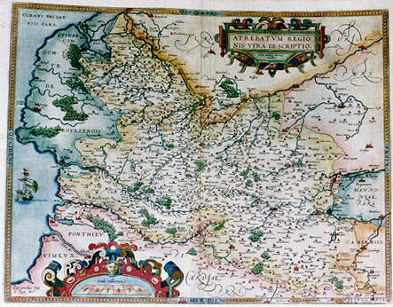
Title: Artois | ATREBATVM REGIO:|NIS VERA DESCRIPTIO. | Johanne Surhonio Montensi | auctore [A true depiction of Artois, the region of the Artois inhabitants] (Low left corner:) "Cum priuilegio Imp. | et Regie Matis". [With an imperial and royal privilege]. From 1595L onwards new dedication replacing ship in the sea: Illustri ac amplis:|simo viro Domino | Christophoro ab | Assonleville, equi:|ti aurato Domino | ab Altevilla R.Mts. | consilario pri:|mario, | "Ab Ortelius in hanc | formam comprćhen: | debat, et dedicabat". [Abraham Ortelius has depicted it in this form, and dedicated it to the most illustrious and important man and lord Christophorus of Assonleville, and the gold-clad horseman the Lord of Altevilla, first councellor of his Royal Majesty].
Plate size: 380 x 490 mm
Scale: 1 : 300,000
Identification number: Ort 72 (Koeman/Meurer: 82, Karrow: 1/117, van der Krogt AN: 3300:31A)
Occurrence in Theatrum editions and page number:
1579/1580L2Add20c (250 copies printed) (24th line from the top ends: Atrebaten- ; last line, centred like 3 lines above it: pulchrč vt cetera,quoque describit Guicciardinus.),
1579L(A)31 (250 copies printed) (24th line from the top ends: Atrebaten- ; 5th line from the top ends vulgo ; last line, centred like 3 lines above it: pulchrč vt cetera,quoque describit Guicciardinus.),
1579L(B)31 (250 copies printed) (24th line from the top ends: Atrebatensem ; 5th line from the top ends vulgň ; last line, centred like 3 lines above it: pulchrč vt cetera,quoque describit Guicciardinus.),
1580G2Add20C (50 copies printed) (identical to 1580/1589G except page number; last line, centred like 6 lines above it, in Gothic script: beschriben.),
1580G31 (350 copies printed) (last line, centred like 6 lines above it, in Gothic script: beschriben.), (note that the 1589G edition contains the later plate of Artois, Ort73),
1581F31 (400 copies printed) (last line, left aligned: region comme aussi plusieurs autres.),
1584L37 (750 copies printed) (last line, centred like 3 lines above it: pulchrč vt cetera, quoque describit Guicciardinus.),
1595L41 (500 copies printed) (last line, left aligned: bit Guicciardinus.),
1598/1610/1613D33 (100 copies printed) (last line, centred like 4 lines above it, in Gothic script like the entire text: wordt lustelijck van "Guicciardino" beschreuen.),
1598F44 (525 copies printed) (last line, left aligned: region, comme aussi plusieurs autres.),
1601L41 (200 copies printed) (last line, left aligned: Hanc regionem pulchrč, vt cetera quoque, describit Guicciardinus.),
1602G44 (250 copies printed) (last line, centred like 6 lines above it, in Gothic script like the entire text: beschriben.),
1602S44 (250 copies printed) (last line, left aligned: esta bien declarada de Guicciardino.),
1603L44 (300 copies printed) (same text but not the same typesetting as 1609/1612L; last line, left aligned: Hanc regionem pulchrč, vt cetera quoque,describit Guicciardinus.),
1606E41 (300 copies printed) (last line, left aligned: This region, as others also adioyning, "Guicciardin" hath most notably described.),
1608/1612I49 (300 copies printed) (last line, left aligned: questa regione & anco l'altre per eccellenza descriue.),
1609/1612L48 (300 copies printed) (same text but not the same typesetting and page number as 1603L; last line, left aligned: Hanc regionem pulchrč,vt cetera quoque,describit Guicciardinus.),
1609/1612/1641S47 (325 copies printed) (last line, left aligned: como las demas,esta bien declarada de Guicciardino.).
From 1587 to 1592, a new plate Ort73 mentions Jacques Surhon as the author of this map. On the new plate the ship is replaced by a dedication to Christophe d'Assonleville. In 1595L the present plate was reintroduced with some changes as specified below.
Approximate number of copies printed: 5650.
States: 72.1 as described. Ship in OCEANI BRITAN:|NICI PARS.
72.2 from 1595L onwards: dedication instead of ship in this area.
72.3 after 1612: name "Theodorus Gallćus excudit Antuerpić" added.
72.4 after 1640: name changed to "Ioannes Gallćus excudit/Antuerpić 1640".
Cartographic sources: Jacques Surhon (not Jean, as erroneously mentioned on this map) made a manuscript map of Artois for which he received 36 Livres in 1554. For security reasons it was not published. Only in 1579, when Antwerpen was independent for a short time, did Ortelius use it. (Meurer p. 250-251). In the 1603 Catalagus Auctorum, we find the name of Jacob S. as the author of maps of Hannonia, Artesia and Lutzenburg "which we have published in our Theatre".
References: H.A.M. van der Heijden "Ortelius and the Netherlands", p. 271-290 in: M. van den Broecke, P. van der Krogt and P. Meurer (eds.) "Abraham Ortelius and the First Atlas", HES Publishers, 1998.
Remarks: the reason for reintroducing this plate in later editions from 1595 onwards when a new plate (Ort 73) was available may have to do with copyright.
In my book "Ortelius Atlas Maps" which appeared in 1996, Ort 72.2-4 is described as a new plate, Ort 74. Meticulous and inventive research by Joe Q. Walker (UK) has demonstrated that this is unwarranted, and that in fact Ort 74 is Ort 72.2-4. Reasons for this conclusion are given in the privately published monograph "The Maps of Ortelius and their Variants", Antiquarian Maps Research Monographs - 1, which can be obtained from the author on request through Email Martran@msn.com
For questions/comments concerning this page, please e-mail info@orteliusmaps.com.