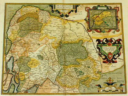
Cartographica Neerlandica Background for Ortelius Map No. 66

Title: BRABANTIAE | DESCRIPTIO. [A representation of Brabant]. (Cartouche middle right:) "Stemmate et eruditione claro | Dn. Hadriano Marsselario, | patricio Antwerpiensi; | Ab. Ortelius dedicab. | L.M." [Dedicated to the honoured and highly erudite Lord Hadrianus Marssellarius, Antwerp patrician, by Abraham Ortelius, willingly, in the month of May]. (Lower right corner:) "Cum Imp. Reg. & | BrabantiŠ priuilegio | decennali. 1591." [With imperial, royal and Brabant privilege for ten years, 1591.] Upper left: "De Peele. Tractus palustris et treme:|bundus, adeo ut vix hominum ferat | vestigia". [The Peel is a marshy area and so trembling that it has hardly any man-made tracks].(Inset map:) MACHLINIAE VRBIS | DOMINIVM. [The area of the city of Mechelen].
Plate size: 371 x 478 mm.
Identification number: Ort 66 (Koeman/Meurer: 126, Karrow: 1/186, van der Krogt AN: 3100:31B)
Scale: 1 : 400,000.
Occurrence in Theatrum editions and page number:
1592L44 (525 copies printed) (last line, left aligned: regionis incolŠ olim fuerunt Ambiuariti & Aduatici. De quibus vide Ioannis Goropij Becani Becceselana.),
1595L38 (500 copies printed) (last line, left aligned: ropij Becani Becceselana.),
1598/1610/1613D30 (100 copies printed) (last line, centred like 3 lines above it, in Gothic script like the entire text: landt van Valcken-Borch: Dalem/ etc.),
1598F41 (525 copies printed) (last line, left aligned: appertenants sous ceste DuchÚ de Brabant.),
1601L38 (200 copies printed) (last line, left aligned: pij Becani Becceselana.),
1602G41 (250 copies printed) (last line, centred like 6 lines above it, in Gothic script like the entire text: nen.),
1602S41 (250 copies printed) (last line, left aligned: region eran antiguamente los Aduaticos: mira acerca d'ello a Ioan Goropio en sus Beccesellanas.),
1603L41 (300 copies printed) (last line, left aligned: biuariti & Aduatici. De quibus vide Ioannis Goropij Becani Becceselana.),
1606E38 (300 copies printed) (last line, left aligned: "Ambiuariti" and "Aduatici." Concerning whom reade "Iohn Goropius Becanus" his "Becesselanis".),
1608/1612I45 (300 copies printed) (last line, left aligned: Ambiuariti & gli Aduatici, de quali vedi le Becceselane del Goropio.),
1609/1612L44 (300 copies printed) (last line, left aligned: regionis incolŠ olim fuerunt Ambiuariti & Aduatici. De quibus vide Ioannis Goropij Becani Becesselana.),
1609/1612/1641S43 or 45 (325 copies printed) (last line, left aligned: Goropio Becano en sus Becceselanas.).
Approximate number of copies printed: 3875.
States: 66.1 as above.
66.2: between 1592 and 1595, the horizontal place name "Bethlem" close to Leuven was removed and re-engraved diagonally. The canal name "Brusselsche vaert" was added North of Vilvoorde and the place names "Capellen" and "Humbeke" were added along this canal.
66.3: for the 1641S version, this plate is used again, but with the date of 1591 removed.
Cartographic sources: this is a copy of the six-sheet map which Jacob van Deventer published in 1536, a reprint of which was produced in 1558 by Arnold Nicolai (Karrow 25/1, p. 143-145, Meurer p. 196).
References: H.A.M. van der Heijden "Ortelius and the Netherlands", p. 271-290 in: M. van den Broecke, P. van der Krogt and P. Meurer (eds.) "Abraham Ortelius and the First Atlas", HES Publishers, 1998
Remarks: Replaces plate Ort 65, which has no inset. For a post-1612 version of BrabantiŠ, blank on verso, to which the name "Theodore Galle" is added, the early plate 65 is used, rather than this late one. The initials in the dedication probably refer to Laurentius Michaelis who may be connected with the Mechelen inset map.
For questions/comments concerning this page, please e-mail info@orteliusmaps.com.