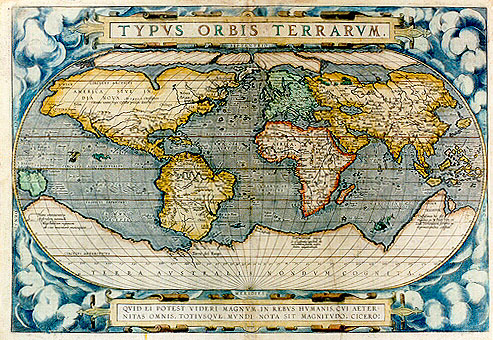
Cartographica Neerlandica Background for Ortelius Map No. 2

Title: TYPVS ORBIS TERRARVM. [Map of the lands of the world]. (bottom cartouche:) QVID EI POTEST VIDERI MAGNVM IN REBVS HVMANIS, CVI ĂTER|NITAS OMNIS, TOTIVSQVE MVNDI NOTA SIT MAGNITVDO. CICERO: [Tusculan Disputations 4.37]. [Who can consider human affairs to be great, when he comprehends the eternity and vastness of the entire world? Cicero]. (bottom left:) "Hanc continentem | Australem, nonnulli | Magellanicam regionem | ab eius inuentore nuncupant. [This Southern continent is by some called the Magellan region after its discoverer.] (lower left:) "Noua Guinea | nuper inuenta | quŠ an sit insula | an pars continentis | Australis incertum est". [New Guinea, recently discovered. Whether this is an island or part of the Southern continent is uncertain.] (Lower left:) "Vasti▀imas hic e▀e | regiones ex M Pauli Ven:et | Lud.Vartomanni scriptis pe: | regrationibus constat". [These regions are very extended, as can be seen in the writings of Paulus Venetus and the travels of Ludovicus Vartomannus.] (Lower right:) Psitacorum regio | "sic a Lusitanis appellata ob | incredibilem earum auium ibidem magnitudem". [This region is by the Portuguese called "of the Psitaci" because of the incredible number of birds of the same size].
Plate size: 333 x 488 mm
Scale: 1 : 80,000,000
Identification number: Ort 2 (not in Koeman, Meurer: 112/II, Karrow: 1/6a, van der Krogt AN: 0001:31B)
Occurrence in Theatrum editions and page number:
most 1587F1 (200 copies printed)(last line, left aligned: seroit bien vn ťuure entier;ce que nous en auons dit,est seulement fait comme en passant.),
all 1588S1 (300 copies printed) (last line of left column, left aligned: ISIDORE HISPALENSE;,
most 1589G1 (200 copies printed) (last line of left column, partly in Gothic script: PtolemŠum.Zacharias Lilius Vicent, von gelegenheit der Welt.),
some 1598D1 (50 copies printed)(last line, centred like two lines above it: maken mit hebben wy hier alleene int corte aenwysen willen.) [This text has also been used in exactly the same form for world map plate 3 in the 1613 Dutch edition].
Approximate number of copies printed: about 750.
States: 2.1: this first state is dated 1586 and occurs in most copies of the 1587F edition.
2.2: in the second state, apparently introduced late in 1587, the date 1586 has been removed.
2.3: in the third state, as mostly occurring in the 1588S edition and in most copies from 1589G (but some still having the second state), few copies of later editions, some as late as 1598D, the south American coastline has been corrected, as is the case in the third plate Ort3, but the clouds in the corners are still retained in plate 2.
Cartographic sources: Gerard Mercator's 1569, Gastaldi's 1561 world map and Diego Gutierrez' portolan map of the Atlantic (Meurer p. 35, Karrow 56/17, 37/1 p. 389-392, 285-287). Next to the list at the end of the text, Ortelius himself mentions in his Catalogus Auctorum the world maps of Petrus ab Aggere from Mechelen, Apianus of Ingolstad, Sebastian Cabotus from Venice, Laurentius Fries, Jacobus Gastaldi, Gemma Frisius of Antwerp, Guicciardini of Antwerp, Doco ab Hemminga Frisius, Mercator, and Orontius FinŠus of Paris,
References: Shirley (1993) map 153. Shirley (1998) The World Maps in the "Theatrum", p. 171-184, in Van den Broecke, van der Krogt and Meurer (eds.) "Abraham Ortelius and the First Atlas", HES Publishers, 1998. Lucia Nuti (2003) The World Map as an Emblem: Abraham Ortelius and the Stoic Contemplation, Imago Mundi 55: 38-55.
Remarks: This map has in the lower cartouche "..ĂTER:|NITAS.." broken over the two lines, whereas it is unbroken on plate Ort 1. Since this map occurs in few editions, it is very rare.
For questions/comments concerning this page, please e-mail info@orteliusmaps.com.