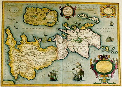
Cartographica Neerlandica Background for Ortelius Map No. 192

Title: BRI:|TANNICA:|RVM INSV:|LARVM | TYPVS. [Map of the British Isles]. (Cartouche upper right:) "Ex conatibus | Geographicis Abrah. | Ortelij. | Cum privileg. decen. | 1595". [From the geographical efforts of Abraham Ortelius]. (Cartouche bottom right:) NATALIBVS | INGENIO ET DOCTRINA | ILLVSTRI REVERENDOQVE | DOMINO D. GEORGIO AB AVS:|TRIA, PRAEPOSITO HARLEBE:|CENSI, AC SERENISS. PRINCIPI | CARDINALI ARCHIDVCI A | CVBICVLIS, | "Abrah. Ortelius R.M. Geog. | L.M. dedicab". [Abraham Ortelius, pleased to be the geographer of his majesty the king dedicates this map, intended as instruction and learning for the people, to George of Austria, servant to the most serene lord, cardinal and archduke of Harlebeck]. (Middle right:) ORCADES "Insulę, triginta plus | minus numero". [The Orkney islands, about thirty in number]. (Left bottom:) "Hoc loco Cęsarem appuliße | prima navigatione putatur". [In this place it is thought that Cęsar landed on his first sea journey].
Plate size: 367 x 511 mm.
Scale: 1 : 2,500,000.
Identification number: Ort 192 (Koeman/Meurer: 34P, Karrow: 1/201, vdKrogtAN: 5000H:31B).
Occurrence in Theatrum editions and page number:
1595LC ((500 copies printed) text, but not page number and typesetting, almost identical to 1601L, 1603L & 1609/1612L; last line, right aligned, ends: incursio; one but last line: ex calamis,aut vt plurimum ex lignis compacta. Vrbium loco ipsis sunt nemora. Opidum enim vocant, cum siluas impeditas vallo aut fossa munierint,quņ ; last line second text page, left aligned: res, loca, & vrbes; sed & medię ętatis , atque nostri sęculi, adeņ doctč & diligenter descripsit, vt non calamo,sed penicillo ob oculos posuisse videatur.),
1601Lix (200 copies printed) (last line first text page, right aligned: quidem ; last line second text page, left aligned: vrbes; sed & medię ętatis, atque nostri sęculi, adeņ doctč et diligenter descripsit, vt non calamo, sed penicillo ob oculos posuisse videatur.),
1602G8 (250 copies printed) (this text in the copy consulted, viz. University Library Groningen, the Netherlands, is identical to that of Ort191 (Southern part of Great Britain, but describing the North and its islands) in 1591G4Add, but the typesetting is different. Since other copies do not seem to contain this "mistake", the text is not translated below. We refer to Ort 191 for it. Last line, left aligned, in Gothic script like the entire text: sul Andros/dauon er schreibt/verstanden. Und so viel von den Insulen/so in diser Tafelen abgerissen vnd entworffen sein.),
1603Lix (300 copies printed) (text and page number, but not typesetting, identical with 1609/1612L; last line, right aligned: putant:) ; last line second text page, left aligned: sęculi,adeņ doctņ & diligenter descripsit,vt non calamo, sed penicillo ob oculos posuisse videatur.),
1606Eix (300 copies printed) (last line, first of four text pages, italic like most of the text, full width: thyst "of" England. "I read in" Solinne "that heere are hot baths" (fontes calidi), "Bathe, I understand) very curiously carued and trimmed for the use of man : these/fountaines, ; last line fourth text page, left aligned, in cursive script: "Maiesty."),
1608/1612Iix (300 copies printed) (last line first text page, in italic script, right aligned: "compon-" ; last line second text page, left aligned: diligentemente descrisse , & con dottrina , che non gia con la penna paia hauet le dinanzi ą gli occhi rappresentate , anzi co'l penello.),
1609L/1612L/Six (600 copies printed) (text and page number, but not typesetting, identical with 1603L; last line, first text page, right aligned: aliarum ; last line second text page, left aligned: fuisse videatur.),
1618 Bertius includes this map with reset text of 1609/1612L, signature RR, (200 copies printed) last line first text page, right aligned: multum; last line second text page: mediętatis,atque nostri sęculi,adeņ doctč & diligenter descripsit,vt non calamo, sed penicillo ob oculos posuisse videatur.),
1624ParergonL/1641Sxj, xij (1025 copies printed) (last line second column first text page: gę scutulę aut bipenni assimilat, ex Liuio, & Fabio | Rustico, ; last line second column second text page: dunt in ea Cęsar & Diodorus. At vnde venerint, | aut ; last line, right aligned, second column third text page: norum ; last line, left aligned, fourth text page, second column: has positas nouimus. ; last line, right aligned, second column fifth text page: Histo- ; last line, left aligned, second column sixth text page: deatur.).
States: 192.1 only
Approximate number of copies printed: 3675.
Cartographic sources: made by Ortelius on the basis of modern information from Mercator's 1564 map of the British Isles, improved by a new outline from Saxton's 1579 map (Meurer p. 197, Karrow 56/16, p. 387-388) and ancient knowledge from Diodorus Siculus, Plinius, Appianus, Tacitus, Cęsar, Strabo and numerous other Roman writers.
References: R.W. Shirley (1991) "Early Printed Maps of the British Isles" 1477-1650, Antique Atlas Pub. East Grinstead, maps 186 (plate 71), 259a, 365.
Remarks: Engraving by Jan Wierix. Bertius bought a number of sheets with this map and included the map in his historical 1619 atlas Theatrum Geographię Veteris. Shirley also reports (p. 105) a copy from a mysterious 1603 edition with Italian text.
Note the elaborate ship just left of the cartouche. It represents state-of-the-art shipbuilding, not of Greek or Roman antiquity, but of the Low Countries towards the end of the 16th century.
The text is among the longest in the entire "Theatrum", demonstrating Ortelius' keen interest in the history of Great Britain.
For questions/comments concerning this page, please e-mail info@orteliusmaps.com.