Cartographica Neerlandica Background for Ortelius Map No. 97
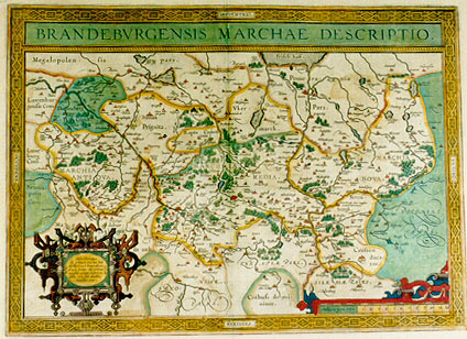
Title: BRANDEBVRGENSIS MARCHAE DESCRIPTIO. [A depiction of the marquisate of Brandenburg](Cartouche lower left:) "Marchionatus | hic primum erectus fuit | ab Henrico I. Imperatore, | a.o 923. fuitque eius primus | marchio nomine Henricus. | Olim enim sub ducibus | Saxoniæ erat." M.CCCCC.LXXXVIII. [This marquisate was first established by Henricus I the emperor in the year 923. The marquisate first went under his name of Heinrich. Once it came under the dukes of Saxony. 1588].
Plate size: 359 x 501 mm
Scale: 1 : 300,000
Identification number: Ort 97 (Koeman/Meurer: 118, K: 1/166, van der Krogt AN: 2170:31).
Occurrence in Theatrum editions and page number:
1590L4Add blank (100 copies printed) (text and typesetting identical to 1592L, but here without page number; last line, left aligned: ex libello Germanico Wolfgangi Iobsti. Lector,si lubet, adde his quæ apud Irenicum & Munsterum sunt.),
1591G4Addblank (75 copies printed) (last line, centred like 3 lines above it, mostly in Gothic script: Munstero zufinden/hinzu setzen.),
1592L53 (525 copies printed) (text and typesetting identical with 1591L4Add but now with page number; last line, left aligned: ex libello Germanico Wolfgangi Iobsti. Lector,si lubet, adde his quæ apud Irenicum & Munsterum sunt.),
1595L56 (500 copies printed) (last line, left aligned: edidit Dauid Chytræus in suo Saxoniæ chronico.),
1598/1610/1613D45 (100 copies printed) (last line, left aligned, in Gothic script like the entire text: mach daer by voeghen "Irenicum" ende "Munsterum"),
1598F58 (525 copies printed) (last line, left aligned: qu'ont escrit Irenie & Munster,& aussi à Dauid Chytreus en son histoire de Saxe.),
1601L56 (200 copies printed) (last line, left aligned: uid Chytræus in suo Saxoniæ chronico.),
1602G59 (250 copies printed) (last line, centred like 3 lines above it, in Gothic script like the entire text: Munstero zufinden/hinzu gesetzt.),
1602S59 (250 copies printed) (last line, left aligned: echó a luz Dauid Cytræo, en su Chronico de Saxonia.),
1603L59 (300 copies printed) (last line, full width: Lector,si lubet,adde his quæ apud Irenicum & Munsterum sunt.& quæ nuper edidit Dauid Chytræus in suo Saxoniæ chronico.),
1606E56 (300 copies printed) (last line, left aligned: storie of
"(S)axonie".),
1608/1612I64 (300 copies printed) (last line, left aligned: te ha dato in luce il Chitreo nella sua Cronica di Sassonia.),
1609/1612L56 or mostly 63 (300 copies printed) (last line, left aligned: træus in suo Saxoniæ chronico.),
1609/1612/1641S62 (325 copies printed) (last line, left aligned: y Munstero,y con esso lo que, a estos passados echó a luz Dauid Cytræo, en su Chronico de Saxonia.).
Approximate number of copies printed: 4050
States: 97.1 only.
Cartographic sources: the astronomer Elias Cameriarus (abt. 1530-1581) made a single sheet map of Brandenburg, used by Mercator for his 1585 Germaniæ tabulæ geographicæ. That map formed the basis for the present map of Brandenburg (Meurer p. 124-125).
For questions/comments concerning this page, please e-mail info@orteliusmaps.com.