Cartographica Neerlandica Background for Ortelius Map No. 5
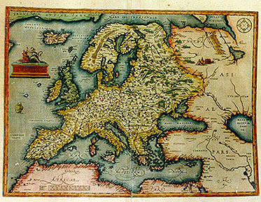
Title: EVROPAE [Europe]
Plate size: 346 x 464 mm
Scale: 1 : 15,000,000
Identification number: Ort 5 (Koeman/Meurer: 110, Karrow: 1/10a, van der Krogt AN: 1000:31B)
Occurrence in Theatrum editions and page number:
1584L2 (750 copies printed) (last four lines in smaller font; last line, indented, in italic script: "iter agentium"),
1587F2 (250 copies printed) (last line, left aligned: autres parties du monde.),
1588S2 (300 copies printed) (last line, left aligned: rolo al cabo del libro cuyo titulo es "De regimine agentium".),
some 1589G2 (50 copies printed),
1592L2 (525 copies printed) (first textline ends: au- ; last line, centred slightly to the right, like 2 lines above it: lielmus Gratarolus fecit in calce libri,qui inscribitur,[italic:] "De regimine iter agentium."),
1595L2 (500 copies printed) (first textline ends: nominis ; last line, centred slightly to the right, like 2 lines above it: lielmus Gratarolus fecit in calce libri,qui inscribitur,[italic:] "De regimine iter agentium.")
1598/1613D4 (100 copies printed) (last line, centred like 4 lines above it: deelen te regeren.),
1598F2 (525 copies printed) (last line, left aligned: idioines & aptes, pour gouuerner les autres parties du monde.),
1601L2 (200 copies printed) (last line, left aligned: Guilielmus Gratarolus fecit in calce libri,qui inscribitur, (cursive from here on) "De regimine agentium".),
1602G2 (250 copies printed) (last line, centred like 4 lines above it, in Gothic script: genandt.),
1602S2 (250 copies printed)(last line, left aligned: Gratarolo al cabo del libro cuyo titulo es [cursive:] "De Regimine agentium".),
1603L2 (300 copies printed) (last line, in cursive script unlike the rest of the text: "De regimine iter agentium". This text and page number are identical to the one used in the 1609/1612L edition, but the typesetting is different. The page number is located at 3/4 of the line to the right, whereas 1609/1612L has the page number 2/3 to the right),
1606E2 (300 copies printed) (last line, left aligned, cursive except for the word "or": "De regimine iter agwentium", or "A direction for trauellers."),
1608/1612I2 (300 copies printed) (last line, left aligned: loro, che fan camino.),
1609/1612/1641S2 (325 copies printed) (last line: left aligned: cuyo titulo es (italic:) "De rigimine iter agentium".),
1609/1612L2 (300 copies printed) (last line, left aligned, italic unlike the rest of the text: "De regimine iter agentium". This text and page number are identical to the one used for the 1603 Latin edition, but the typesetting is different; this edition has the page number at 2/3 to the right, whereas 1603L has the page number 3/4 to the right.).
States: 5.1 only.
Approximate number of copies printed: 5250.
Cartographic sources: Gerard Mercator's 1554 map of Europe. Greenland from Mercator's 1569 world map. Both these maps for Iceland. Great Britain after Mercator's 1564 Great Britain map. Scandinavia from Olaus Magnus' 1539 Scandinavia map. Russia is based on Jenkinson's 1562 Russia map. South-East part of this map based on Gastaldi's first map of Asia of 1559. Parts of the North African coast are based on Gastaldi's Africa map of 1664. (Meurer p. 36, Karrow 56/13, and 53/1 p. 386, 363). Ortelius himself mentions in his Catalogus Auctorum also the Europa maps of Apianus, Cornelius Antonii of Frankfurt, Aurigarius Lucas printed in Amsterdam, Ioannes Bucius Ćnicola of Paris, Jacob Homem Lusitanus printed in Venice, Jodocus Hondius, Ioannes Dominicus Methoneus of Venice, Nicolaus Nicolay printed in Antwerp by Ioannes Stelsium, Vopelius, Waldseemüller, Christoph Zell and Heinrich Zell of Nurnberg.
Remarks: Replaces plate Ort 4, which has non-cursive capitals "AFRICĆ PARS" and is of superior engraving quality.
For questions/comments concerning this page, please e-mail info@orteliusmaps.com.