Cartographica Neerlandica Background for Ortelius Map No. 3
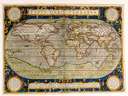
Title: TYPVS ORBIS TERRARVM. [Image of the countries of the world]. [bottom cartouche:] QVID EI POTEST VIDERI MAGNVM IN REBVS HVMANIS, CVI ĆTER|NITAS OMNIS, TOTIVSQVE MVNDI NOTA SIT MAGNITVDO. CICERO: [Tusculan Disputations 4.37] [Who can consider human affairs to be great, when he comprehends the eternity and vastness of the entire world? Cicero, [lower right corner:] "Ab. Ortelius describ. cum | priuilegio decennali.|1587". [Described by Abraham Ortelius, with a ten year privilege. In 1587]. [Top left cartouche:] HOMI|NES HAC LEGE | SVNT GENERATI, | QUI TVERENTVR | ILLVM GLOBVM, | QVEM IN HOC TEM|PLO MEDIVM VI|DES, QUĆ TER|RA DICITVR. Cicero ["Republica" 6.15.]. [People have been created under the law that they should protect this globe which you see in the middle of this image which is called earth]. [Top right cartouche:] EQVVS | VEHENDI | CAVSA, ARANDI | BOS VENANDI | ET CVSTODIENDI | CANIS, HOMO AV|TEM ORTVS AD | MVNDVM CON|TEMPLANDVM. Cicero ["Natura Deorum" 2.37]. [The horse is for riding, the ox for ploughing, the dog for hunting and guarding, but man was born to contemplate the world]. [Bottom left cartouche:] HOC | EST PVNCTVM, | QVOD INTER TOT | GENTES FERRO | ET IGNI DIVI|DITVR. O QVAM RIDI|CVLI SVNT MOR|TALIVM TER|MINI. Seneca ["Naturć Qućstiones" 1. prćfatio 8-9]. [This is the time when [the world] is divided by the fire and sword of many nations. How ridiculous are the goals of mortal beings]. [Bottom right cartouche:] VTINAM | QVEMADMO|DVM VNIVERSA | MVNDI FACIES | IN CONSPECTVM | VENIT, ITA PHI|LOSOPHIA TOTA | NOBIS POSSET | OCCVRRERE. Seneca [Epistle 89.1]. [We wish, just like the universe and face of the world comes into view, that it could similarly happen that philosophy could be made visible to us].[In North America:] AMERICA SIVE IN:|DIA NOVA "Ao 1492 a Christopohoro | Colombo nomine regis Castellć primum detecta". [America or the New Indies, first discovered by Christopher Columbus in 1492 for the king of Castilia.] [On New Guinea:] Noua Guinea, | "quć an sic insula | aut pars continentis | Australis, incertum". [New Guinea. Whether this is an island or part of a Southern continent is uncertain.] [Lower left below New Guinea:] "Hanc continentem | Australem , nonnulli | Magellanicam regionem ab | eius inventore nuncupant". [This Southern continent is by some called the Magellan region after its discoverer]. [Below South Africa:] Psitacorum regio, | "sic a Lusitanis appellata ob incre:|dibilem earum avium ibidem | magnitudem". [The region of the Psitaces, so called by the Portuguese because of its incredibile amount of birds of the same size.][Text block below Indonesia:] "Vastissimas hic eße | regiones ex M. Pauli Ven: et | Lud. Vartomanni scriptis pe:|regrinationibus constat". [These regions are very extended as can be seen in the writings of Marco Polo and the travels of Ludovicus Vartomannus.]
Plate size: 358 x 492 mm
Scale: 1 : 80,000,000
Identification number: Ort 3 (Koeman/Meurer: 113, Karrow: 1/6b, van der Krogt AN: 0001:31C)
Occurrence in Theatrum editions and page number:
few 1589G1 (50 copies printed),
1592L1 (525 copies printed) (3rd textline from the top ends: Africam; last line, in two columns: ANTONIVS VERONENSIS; FRANCISCVS BELLEFORESTIVS, Gallicč.),
1595L1 (500 copies printed) (3rd textline from the top ends: scili- ; last line, in two columns: ANTONIVS VERONENSIS; FRANCISCVS BELLEFORESTIVS, Gallicč.),
most 1598/1610D1 (75 copies printed),(last line, centred like two lines above it: maken mit hebben wy hier alleene int corte aenwysen willen.),
1598F1 (525 copies printed) (last line, left aligned: seront bien vn śuure entier:ce que nous en auons dit, est seulement fait comme en passant.),
1598/1610/1613D1 (25 copies printed)(last line, centred like 2 lines above it, in Gothic script like the entire text: maken dit hebben wy hier alleene int corte aenwysen willen.),
1601L1 (200 copies printed) (3rd textline from the top ends: Eu- ; last line, in two columns: ANTONIVS VERONENSIS; FRANCISCVS BELLEFORESTIVS, Gallicč.),
1602S1 (250 copies printed) (last line, in two columns: ISIDORO HISPALENSE; FRANCISCO BELFORESTIO, en Francez.),
1602G1 (250 copies printed) (last line, left column of two, partly in Gothic script: vber Ptolemćum. Zacharias Lilius Vicent, von Gelegenheit der Welt.),
1603L1 (300 copies printed) (15th line from the top ends with cursive "instauramus"),
1606E1 (300 copies printed) (last line first column: ANTONIVS VERONENSIS, second column: FRANCISCVS BELLEFORESTIVS done in the French tongue.),
1608/1612I1 (300 copies printed) (last line, last part of first and second column: FRATE ANTONIO PIGAFETTA, Cauallier dell'ordine di S. Gio- idioma Italico.),
1609/1612/1641S1 (325 copies printed) (last line, in two columns: GVALTERO LVDOVICO, en el Espejo d'el Orbe; FRANCISCO BELFORESTIO, en Francez.),
1609/1612L1 (300 copies printed) last line, in two columns: ANTONIVS VERONENSIS; FRANCISCVS BELLEFORESTIVS, Gallicč; 15th line of text from the top ends with cursive "bella".),
1610/1613D1 (75 copies printed(text identical to 1598D. Some of the 1598D have Ort2 rather than Ort3 as their world map. The 1613D edition always has Ort3 (last line, centred like 2 lines above it, in Gothic script like the entire text: maken dit hebben wy hier alleene int corte aenwysen willen).
Approximate number of copies printed: about 4000.
This map replaces plates Ort 1 and Ort 2, has the corrected coastline of South America, medallions in the four corners, and no clouds.
States: 3.1 as described.
3.2: in or after the 1613 Dutch edition, Le Maire Strait was added, and the date 1587 removed. Only horizontal hachuring behind strapwork. The copy of this state that we inspected was blank on verso.
3.3: in a version after 1613 Dutch including the features of state 3.2, there is horizontal and vertical hachuring behind the strapwork.
Cartographic sources: Gerard Mercator's 1569, Gastaldi's 1561 world map and Diego Gutierrez' portolan map of the Atlantic (Meurer p. 35, Karrow 56/17, 37/1 p. 389-392, 285-287). Next to the list at the end of the text, Ortelius himself mentions in his Catalogus Auctorum the world maps of Petrus ab Aggere from Mechelen, Apianus of Ingolstad, Sebastian Cabotus from Venice, Laurentius Fries, Jacobus Gastaldi, Gemma Frisius of Antwerp, Guicciardinus of Antwerp, Doco ab Hemminga Frisius, Jodocus Hondius of Amsterdam, Mercator, Orontius Finćus of Paris, and Petrus Plancius.
Remarks: Quite a few of the new place names appearing along the North American west coast were provided to Ortelius by Hakluyt on the basis of recent explorations, which were not published for political reasons.
References: Shirley (1993) map 158. Shirley (1998) The World Maps in the "Theatrum", p. 171-184, in Van den Broecke, van der Krogt and Meurer (eds) "Abraham Ortelius and the First Atlas", HES Publishers, 1998. Lucia Nuti (2003) The World Map as an Emblem: Abraham Ortelius and the Stoic Contemplation, Imago Mundi 55: 38-55.
For questions/comments concerning this page, please e-mail info@orteliusmaps.com.