Cartographica Neerlandica Background for Ortelius Map No. 213
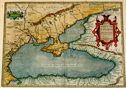
Title: (in Greek lettering:) PONTOS | EUKSEINOS. | PONTVS | EVXINVS. [The hospitable (Black) Sea]. | Æquor Iasonis pulsa:|tum remige primum. [The flat one, first stirred by Iasons oar]. | "Cum | Priuilegio Imp. Reg. et Belgico,|Ad decennium.|1590." [With imperial, Royal and Belgian privilege for ten years, 1590]. (Cartouche upper left:) "Ex conatibus geographi:|cis Abrahami Ortelij". [From the geographical efforts of Abraham Ortelius]. (Upper left:) Callipedes, "ubi Exampe:|us locus, et fons. Incolis Sa:|cræ Viæ vocatur. Hinc | Hypanis dulcißimi sa:|poris fluvius, amaras aquas | suscipit. et fit sui dißimilis". [Callipedes, where there is the place and spring called Exampeus. It is by the inhabitants called the Sacred Road. From here flows the river Hypanis, which has water of the sweetest taste. It receives bitter water, turning it into water unlike its own]. (Lower left:) "Tetrisia prom. quod et Tiristris, atque Cetirizis in quo | Bizona urbs, | terremotu inter:|cidit". [Cape Terisia, also called Tiristris and Cetirizeis, on which the city of Bizona perished in an earthquake.] (Upper left:) Gerrhus, "locus ubi | regum Scytharum se:|pulcra". [Gerrhus, the place where the graves of the Scythian kings are]. (Middle top:) Ry:paei montes, ad Tanais usque originem. [The Rypaei mountains, which extend to the source of the river Tanais]. [Right centre:] MAEOTIS PALVS: | "Quam Scythiæ gentes circundant | vndique ripis, | Et matrem Ponti perhibent | Mæotidis undam." [The swamps of Mæotis, around which the Scythian tribes live, on all shores around it, and they say that the mother of the Pontus sea rules its waves]. (Bottom centre:) GALATIA, QUÆ | ET GALLOGRAECIA, "Cui:|us incolæ" Buccellarij. [Galatia, also called Gallograecia, of which the inhabitants are the Buccellari]. (Top right:) "Tanais, com:|mune emporium | Europæorum et Asia:|ticorum". [Tanais, the common market of the Europeans and Asians]. (Top right:) "Agios, id est | Sanctus, mons". [Agios, which means Holy Mountain]. (Top right:) "Tanais flu. Quique duas terras, Asiam Cadmique | sororem. Separat. et cursus inter | vtramque facit". [The river Tanais, which divides two lands, Asia and the sister of Cadmus [i.e. Europa], and finds its course between the two.] (More text blocks in Topographical Names).
Plate size: 359 x 505 mm.
Scale: 1 : 3,750,000.
Identification number: Ort 213 (Koeman/Meurer: 17P, Karrow: 1/181, van der Krogt AN: 0350H:31).
Occurrence in Theatrum editions and page number:
1590L4Addblank (100 copies printed) (identical to 1592L in text and typesetting, but here without page number; last line, left aligned, : initium. Eius longitudinem ad sex millia stadiorum extendi, scribit Themistius Euphrada.),
1591G4Addblank (75 copies printed) (last line, left aligned, in Gothic script like the entire text: das deren lenge auff sechs Dausent feldtwegs sich erstrecke.),
1592L15 (525 copies printed) (identical in text and typesetting to 1590L4Add, but here with page number 15; last line, left aligned: initium. Eius longitudinem ad sex millia stadiorum extendi, scribit Themistius Euphrada.),
1595LT (500 copies printed) (last line, left aligned: rem vsque contusa,pro farre est,quia teste Pomponio,pabula haud largè ferunt.),
1601Lxxv (200 copies printed) (last line, left aligned: ta,& in puluerem vsque contusa,pro farre est,quia teste Pomponio,pabula haud largè ferunt.),
1602G23 (250 copies printed) (da schreibt/das deren lenge auff sechs tausend Feldtwegs sich erstrecke.),
1603L rarely xxv, mostly xxvij (300 copies printed) (text and page number, but not typesetting, identical with the editions 1609/1612S/L; page number under the word magnorum in penultimate text line, last line, left aligned: siccata, & in puluerem vsque contusa, pro farre est, quia teste Pomponio, pabula haud largè ferunt.),
1606Exxv (300 copies printed) (last line, left aligned: no great store of prouision for victuals.),
1608/1612Ixxvij (300 copies printed) (last line, left aligned: alla poluere.),
1609/1612Sxxvij (text in Latin) = 1609/1612Lxxvij (600 copies printed) (text and page number, but not typesetting, identical to 1603L; page number under the word magnorum of penultimate line of text; last line, left aligned: siccata, & in puluerem vsque contusa, pro farre est, quia teste Pomponio, pabula haud largè ferunt.),
1618BertiusFFF (200 copies printed) (last line first text page, right aligned: næus, ; last line second text page, left aligned: contusa, pro farre est, quia teste Pomponio, pabula haud largè ferunt.),
1624P/1641Sxxxj (1025 copies printed) (last line, second column, first text page, right aligned, in cursive script: "ces" ; last line, second column, second text page, left aligned: teste Pomponio,pabula haud largè ferunt.).
Approximate number of copies printed: 4375.
States: 213.1 as described;
213.2:in 1601, the river name "Charus flu" was added (middle right, just East of the region Heniochi);
213.3: "Boreum Ostium" middle left, changed into "Borium Ostium".
Cartographic sources: made by Ortelius on the basis of modern information from Mercator's South-East Europe atlas which appeared in 1589, (Meurer p. 199) and ancient knowledge from Plinius, Ovidius, Strabo, Apollonius, Procopius and Appianus.
Remarks: Bertius bought a number of sheets with this map and included the map in his historical 1618 atlas "Theatrum Geographiæ Veteris".
For questions/comments concerning this page, please e-mail info@orteliusmaps.com.