Cartographica Neerlandica Background for Ortelius Map No. 170
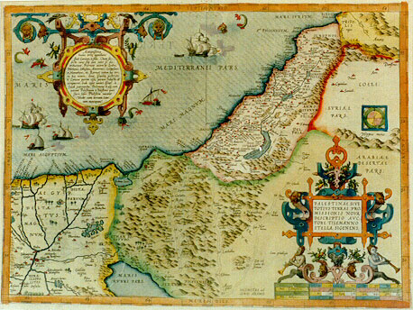
Title: "PALESTINAE SIVE | TOTIVS TERRAE PRO:|MISSIONIS NOVA | DESCRIPTIO AVC:|TORE TILEMANNO STELLA SIGENENS. Cum priuilegio" [A new representation of Palestine or all of the promised land by Tileman Stella from Siena with privilege] (Round cartouche upper left with 15 lines of text: "Antiquißima | huius terrć appellatio | fuit Canaan, ŕ filio Cham sic | dicto: cuius filij eam inter se dis:|tribuerunt. Fuerunt autem hi Sydon, | Hethćus Iebusćus, Amorreus, Gergesćus, | et Hamathćus etc. Retinuit autem hćc ter:|ra hoc nomen, donćc Israelitć posterita:|te Canaan partim cćsa, partim subacta eă | occuparent: Inde cćpit uocari Israel ŕ | Iacob patriarcha. Ptolemeus et alij eam | uocant Palestinam ŕ Palestinis quos | sacri libri Philistim uocant | Hodie eam terram Sanc|tum noncupant".) [The oldest name of this land was Kanaan, so called after the son of Cham, whose sons divided it among themselves. Here were Sydon, Hethćus, Iebusćus, Amorreus, Gergesćus, Hamathćus etc. This country retained this name when the Israelites and their issue occupied Kanaan, partly through battles, partly by subjection. Archfather Jacob was the first to call it Israel. Ptolemćus and others call it Palestina after the Palestines, who in the holy books are called Philistines. Now it is called the Holy Land].
Plate size: 355 x 477 mm
Scale: 1 : 1,500,000
Identification number: Ort 170 (Koeman/Meurer: 51, Karrow: 1/71, vdKrogtAN: 8150:31A).
Occurrence in Theatrum editions and page number:
1570L(A)51 (100 copies printed) (last line, left aligned: His,quis potest adiungere Georgij Agricolć Hammonij Itinerarium Beatć Marić.),
1570L(B)51 (100 copies printed) (last line, centred like 3 lines above it: Itinerarium Beatć Marić.),
1570L(C)51 (125 copies printed) (last line, centred like 5 lines above it: Itinerarium Beatć Marić.)
1571L51 (275 copies printed) (identical with 1570L(C), last line, centred like 5 lines above it: Itinerarium Beatć Marić.),
1571/1573D51 (350 copies printed) (last line, in Gothic script like the entire text, centred like one line above it: weerdicheyt ghelesen ende bedacht moghen worden.),
1572G51Koler (pasted over p.51 of a 1570L edition; few copies printed)(last line, left aligned, mostly in Gothic script: von derselben newlichen Adamus Reisnerus, 7.Bücher außgehen lassen/ Zu disen kan einer auch nemen/der seligen Marie Rayse/von Georgio Agricola Hammonio beschriben.),
1572/1573G51 (225 copies printed) (last line, centred like 6 lines above it: mugen vverden.),
1572/1574F51 (225 copies printed) (last line, centred like 3 lines above it: en grande reuerence & deuotion.),
1573L(A)66 (40 copies printed) (last line, centred like 2 lines above it: Iudaico.6.cap.6.& nuper septem libris Adamus Reisnerus.),
1573L(B)66 (40 copies printed) (last line, centred like 3 lines above it: & nuper septem libris Adamus Reisnerus.),
1574L66 (175 copies printed) (large page number, 11 mm; 14th line from the bottom ends: ćterna,quam- ; last line, centred like 3 lines above it: co.6.cap.6.& nuper septem libris Adamus Reisnerus.),
1575L66 (100 copies printed) (small page number, 7 mm; 14th line from the bottom ends: ćterna, quam= ; last line, centred like 3 lines above it: co.6.cap.6.& nuper septem libris Adamus Reisnerus.).
Approximate number of copies printed: 1750.
States: 170.1: some early 1570L(A) copies (as in University Library Leiden) have no wave patterns in the sea. None of the ships fire. These are possibly preprints from before 1570.
170.2: 1570L(B) shows faint wave patterns added in the sea. Three ships firing. Dots added in the scale lower right: second line after 5, 15 and 20. Fourth line after 40. Town without name added at the start of the Jews' crossing of the Red Sea..
170.3: In 1572 the waves have been re-engraved more prominently. Second monster from the left in upper left cartouche receives extended horizontal hatching. Lowest ship receives new cross-hatching on the right part of its sail, going from upper right to lower left. Right bottom cartouche also reworked: the band around the head of the middle lion has horizontal hatching in state two, but cross-hatching in this third state.
Cartographic sources: Stella 1552, 1557 (Karrow p. 72/5, p. 502-503, Meurer p. 244-245).
References: Tooley (1978) "Maps of Palestine in the Atlas of Ortelius", in "The Map Collector" 3 p. 28-31.
Remarks: Succeeded by plate Ort 171 which has four of five ships firing and one sea monster, rather than three sea monsters and none to three ships firing, as we can find on this map.
For questions/comments concerning this page, please e-mail info@orteliusmaps.com.