Cartographica Neerlandica
HAS THE FOURTH
ORTELIUS AMERICAS
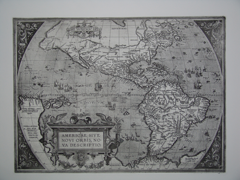 In March 2005 I was approached via internet by a man
living in Paris who claimed to have the copperplate of Ortelius' third map of
the Americas, the first and only one without the bulge on the west coast of
South America, my identification number Ort11. He sent a photograph of the
copperplate and also a photograph of a recent offprint made from this plate on
modern paper. Inspection of the photograph of the offprint showed that it was
the first state of this map, with the Ortelius identification and date 1587 in
the lower right area of the map, and without the addition of Le Maire straight
and Terra Fuego which first appeared in the rare state 2 of 1620 and later
(about ten copies known to exist). Therefore, I responded that this could not
be the original Ortelius copper plate of Ort11. The copper plate was also shown
to Mr. Bracke of the Royal Library of Belgium in
In March 2005 I was approached via internet by a man
living in Paris who claimed to have the copperplate of Ortelius' third map of
the Americas, the first and only one without the bulge on the west coast of
South America, my identification number Ort11. He sent a photograph of the
copperplate and also a photograph of a recent offprint made from this plate on
modern paper. Inspection of the photograph of the offprint showed that it was
the first state of this map, with the Ortelius identification and date 1587 in
the lower right area of the map, and without the addition of Le Maire straight
and Terra Fuego which first appeared in the rare state 2 of 1620 and later
(about ten copies known to exist). Therefore, I responded that this could not
be the original Ortelius copper plate of Ort11. The copper plate was also shown
to Mr. Bracke of the Royal Library of Belgium in
Since the photograph
of the map suggested that this was not a crude imitation of an Ortelius
copperplate, I investigated the possibility that what I so far considered as
the second state of Ort11, might in fact be a new plate, in which case this
copperplate might be authentic after all. Inspection of the second state or
perhaps plate at the Antwerp Municipal Library, which owns a copy of the rare
1641 Spanish edition of the "Theatrum" including state 2 of the rare
Americas map made it clear to me that this second state was not a new plate:
comparison of this Ort11.2 with 8 copies of Ort11.1 of my own showed that a
horizontal crack developed in the upper right corner, first visible in a copy
from the 1608/1612 Italian edition, which worsened in the copy from the
1609/1612 Latin edition. This crack extended further in the
The next step was to
examine the plate and its offprint in
The map turned out to
be almost identical to the standard Ort11.1 both in size and engraving, except
that in the longitude degrees given along the bottom of the map we find 260 70
280 instead of the normal numbers found on Ort11: 260 270 280
There are also some
minor differences in the ornaments in all four corners.
As regards its known
history, the plate was found inside a chimney a little more than 20 years ago
by the father of the present owner when he demolished that chimney in an old
house belonging to his parents in
The surface of the
plate is scratched in some places, possibly as a result of the method of its
retrieval. It has the same dimensions (353 x 484 mm) as the standard Ort11 and
is engraved in the style typical of Ortelius plates, and apart from the missing
numeral, the offprint is easily confused with Ort11.
It is obvious that
this is not the plate with which Ort11.1 and Ort11.2 offprints have been made,
but the resemblance is very outspoken indeed. It cannot be established whether
this plate was made as a close copy of Ort11.1 or that Ort11.1 was made as a
close copy of this plate. Was it made with Ortelius'knowledge or not? How did
it end up in
Assuming that it was
made by Ortelius, why is it that 2 nearly identical plates of the same area
have been made, possibly around the same time, viz. 1587? There are other cases
where there were two plates of the same area. Some of these were made and/or
used simultaneously with their counterpart. But in all these cases there are
more differences which can be identified more easily than is the case here.
I would be very
pleased to hear if any copies printed from this plate with its missing numeral
viz. 70 instead of normal 270, have been printed in Ortelius' time. Just check
the bottom line longitude numbers of the copy you may have access to.
Meanwhile, a copy has
turned up in the
Please mail me at info@orteliusmaps.com with your
findings.
Examples
of two or more plates of the same area:
Ort29/30: Valentia were used simultaneously until 1602 but Ort30 is
visibly more elegantly engraved and forms the large majority of copies printed;
Ort44/45: Caletensium/Veromanduorum, only used simultaneously in 1595;
Ort44b Veromanduorum has South at the top, Ort45b has North at the top;
Ort61/62: Gelria, used simultaneously from 1579 to 1612, different ship
in sea and ornaments in cartouche, further fairly close copies, Ort62 copies
rare throughout the life time of this plate;
Ort70/71: Hannonia, used simultaneously from 1584 to 1612; lower left
corner entirely different, Ort70 copies somewhat more numerous than Ort71
copies;
Ort75/76: Flandria, fairly similar but used consecutively, switch of
plates in 1579;
Ort117/118: Italy, rather different, used consecutively, switch of
plates in 1584 but Ort117 used again in 1641;
Ort152/153: Transilvania, used simultaneously in 1575 only, after that
Ort118 only, rather different, different number of lines in right cartouche;
Ort154/155: Polonia, rather different, used simultaneously in 1595 only,
after that Ort155 only;
Ort168/169: Turkey, fairly similar in geography but different cartouche,
used simultaneously in 1579, after that Ort169 only;
Ort170/171/172: Palestina closely similar except for ships and lettering
upper right, but used consecutively, Ort170 until 1579, Ort 171 until 1595,
Ort172 until 1624;
Ort178/179: Geographia Sacra, geography similar but cartouches very
different, very few copies of Ort178 in 1598 and 1601, all other editions have
Ort179;
Ort182/183: Abraham, close copies, but background hachuring at different
angle, used simultaneously throughout the period 1590-1624; copies of Ort183
are about four times as numerous as those of Ort182;
Ort194/196: Ancient France, entirely different, used simultaneously.
Ort197/198: Ancient Low countries, fairly similar, but different date,
and used consecutively, switch of plates in 1595;
Ort199/200: Ancient Germany, close copies, only some region lettering
different, used consecutively, Ort199 in 1590, Ort200 from 1591 onwards;
Ort204/205: Ancient Italy, geography fairly similar, cartouches very
different, only used simultaneously in 1592 and 1595, after that Ort205 only;
Ort207/208: Ancient Tuscany, geography close copy, cartouches rather
different, used consecutively, swith of plates in 1595.
Of all these cases,
the two