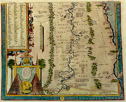
Cartographica Neerlandica Background for Ortelius Map No. 220

Title: TERRA | SVIS CON:|TENTA BONIS, | NON INDIGA | MERCIS, AVT | IOVIS, IN SOLO | TANTA EST | FIDVCIA | NILO. [A land that of itself is rich enough, needs no foreign aid, Iove's help it scorns, relying as it does on the bounty of the Nile] (Lucanus, Book 8). (Bottom right corner:) "Cum Priuilegio Imperiali et | Belgico, ad decennium. 1584". [With an Imperial and Belgian privilege for ten years. 1584]. (Top left: cartouche with list of cartographic places and regions whose positions are uncertain). More text blocks in Topographical Names.
Plate size: 394 x 482 mm.
Scale: 1 : 1,000,000
Identification number: Ort 220 (Koeman/Meurer: 5P, Karrow: 1/163, van der Krogt AN: 8650H:2:31A).
Occurrence in Theatrum editions and page number:
1584L3Addblank (100 copies printed) (identical with 1584L, but here without page number; last line, left aligned: num diuulgata,ex primitiuŠ ecclesiŠ monumentis docetur.),
1584L110 (750 copies printed) (identical with 1584L3Add, but here with page number; last line, left aligned: num diuulgata,ex primitiuŠ ecclesiŠ monumentis docetur.),
1584G3Add3 in upper right corner (75 copies printed) (last line, left aligned, in Gothic script like the entire text: wir au▀ den Schrifften der alten kirchen lehrnen.),
1585F3Add24 (75 copies printed) (last line, full width: premierement sortis de ce pays,& puis espars par tout le monde.),
1587F108 (last line, left aligned: espars par tout le monde.),
1592L21 (525 copies printed) (last line, left aligned: librum Stromatum Clementis Alexandrini.).
States: 220.1 only.
Approximate number of copies printed: 1775.
Cartographic sources: Ortelius' own two-sheet map of Ancient Egypt, dedicated to the humanist and medical doctor Scipio Fabio from Bologna, which appeared in 1565, and for which Ortelius mentions as sources Diodorus, Herodotos, Strabo and Plinius (Meurer p. 21-22).
References: G. Schilder (1987) "Monumenta Cartographica Neerlandica" II, Canaletto, p. 8-9. P.H. Meurer "Ortelius as the Father of Historical Cartography", p. 133-159 in: M. van den Broecke, P. van der Krogt and P.H. Meurer (eds.) "Abraham Ortelius and the First Atlas", HES Publishers, 1998.
Remarks: This map, together with Ort 219, was replaced by one sheet map plate Ort 221, in 1595L.
For questions/comments concerning this page, please e-mail info@orteliusmaps.com.