Cartographica Neerlandica Background for Ortelius Map No. 208

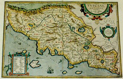
Title: TVSCIAE | ANTIQVAE | TYPVS. | "Ex conatibus geographicis | Ab. Ortelij". [Map of Ancient Tuscany, from the geographical efforts of Abraham Ortelius]. (Cartouche middle right:) "Cum | priuilegio Impe:|riali et Belgico | ad decennium. | 1584". [With an imperial and Belgian privilege for ten years. 1584]. (Cartouche bottom left: List with names of uncertain location in two columns). (Lower left:) "Squalet lucifugis insula plena | viris Rutil. lib.1". [This island lies waste, full of people as it is, who are afraid of the light]. (Lower left:) "Insula inexhaustis calibum | generosa metallis, Virg". [According to Vergilius, this island yields an inexhaustible supply of steel]. (Upper left:) "Auser fluuius hodie se | minime in Arnum exo:|nerat sed a Luca | mare recta | petit". [The river Auser, which now hardly empties itself in the river Arno, but goes directly to the sea.] (Upper right:) "Capras, ubi Toti:|las interfectus". [Capras, where Totilas was killed]. (Upper left centre:) "Fesulani montes de quibus | Orosius 7.cap.37. ubi Radagaision Gothorum regem cum ducentis | millibus hominum inedia confectos tra:dit". [The Fesulani mountains, about which Orosius in his 7th book, chapter 37 tells that Radagaision, the king of the Goths with 2000 men were defeated without having had any food].
Plate size: 322 x 487 mm.
Scale: 1 : 750,000.
Identification number: Ort 208 (not in Koeman, Meurer or Karrow, van der Krogt AN: 7200H:31B).
Occurrence in Theatrum editions and page number:
1595LM (500 copies printed) (last line, left aligned: Sarmatia,Ptolemæo:& Tyrrheni in Atticis insulis,si fides habenda sit Myrsilo Lesbio.),
1601Lxx (200 copies printed) (11th line from the bottom ends: oppida ; last line, left aligned: matia, Ptolemæo: & Tyrrheni in Atticis insulis, si fides habenda sit Myrsilo Lesbio.),
1602G18 (250 copies printed) (last line, left aligned, in Gothic script like the entire text: Diodorus.),
1603L seldom xx, usually xxij (300 copies printed) (text and page number, but not typesetting, identical to the editions 1609/1612S/L; 11th line from the bottom ends: op- ; last line, left aligned: matia,Ptolemæo:& Tyrrheni in Atticis insulis,si fides habenda sit Myrsilo Lesbio.),
1606Exx (300 copies printed) (last line, left aligned: belonging to "Attica", if you will beleeue "Marsylus Lesbius".),
1608/1612Ixxij (300 copies printed) (last line, left aligned: reni etiando nell'isole dell'Attica.),
1609/1612Sxxij (text in Latin)= 1609L/1612Lxxij (600 copies printed) (text and page number, but not typesetting, identical with 1603L; 11th line from the bottom ends: ob- ; last line, left aligned: matia,Ptolemæo:& Tyrrheni in Atticis insulis,si fides habenda sit Myrsilo Lesbio.),
1624ParergonL/1641Sxxvj (1025 copies printed) (last line second column first text page, right aligned: Multum ; last line second text page second column, left aligned: Lesbio.).
Approximate number of copies printed: 3475.
States: 208.1 as described;
208.2: between 1595 and 1601 Roman roads were introduced: "Clodia Via" which runs along the North side of the map and from mid North veers downwards to Rome; also "Via Flamminia" which runs from Rome Northwards, and more.
Cartographic sources: made by Ortelius, based on Bellarmati's map of Tuscany (Meurer p. 113, Karrow 10/1, p. 78-80), supplemented by classical sources, viz. Livius, Plinius, Cato, Vergilius, Halicarnassæus and Plutarchus.
Remarks: this plate succeeds Ort 207 from 1595L onwards. It has "LATII PARS" in cursive lettering above and below privilege cartouche. The ship sails westwards in the early plate, eastwards in this late plate Ort 208.
For questions/comments concerning this page, please e-mail info@orteliusmaps.com.