Cartographica Neerlandica Background for Ortelius Map No. 168

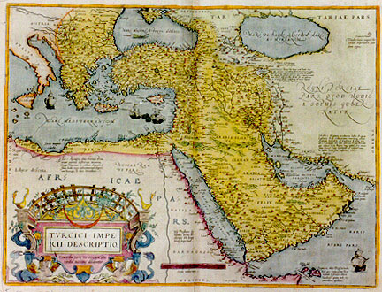
Title: TVRCICI IMPE:/RII DESCRIPTIO. | "Concordia parvŠ res crescunt, Dis|cordia maximŠ dilabuntur:" [A depiction of the Turkish empire. Through unity small things grow, through discord they fall asunder]. (Lower right centre:) "Cum priuilegio." [With privilege]. (Text of 7 lines below Caspian sea:) "Tauris ol: Echnata, regum Persarű sedes | GELVCHALAT dicitur hic lacus a M. Paulo Ven: | ab alijs ARGIS. a Strabone fortŔ MARTIANA palus, | situs est inter confinia A▀yriŠ. ArmeniŠ & MediŠ | hic magna fit piscatio per 40. dies tempore vernali, | nam ceteris anni partibus sterilis est. quŠ pisces ae:|re et uento sicati, induratique in vicinis regioni:|bus mercatui exponuntur". [This lake was called Geluchalat by Marco Polo of Venice, by others it was called Argis, by Strabo the Martian swamps. It is situated at the borders of Assyria, Armenia and Media. There is supposed to be large scale fishing here for 40 days during spring, because it dries out during the rest of the year. Those fishes, dried and hardened by the open air and winds, are offered for sale on the markets in the surrounding area.] (Text block right centre, in present day Iran:) "ORMVS Regnum, peculiarem habet Regem | LusitaniŠ Regi tributarium: continetque totam | Arabiam littoralem ab Euphratis fl. ostio vsque | ad C. Razalqati, nec nom partem Regni Persidis | quŠ adiacet freto BasorŠ, atque insulas fere omnes | sinus Persici. Cuius metropolis est vrbs Ormus | in insula Geru sita, emporium celebre". [The kingdom of Ormus has as a distinctive feature a king who is a tributary to the king of Lusitania. It comprises all the Arab coasts from the mouth of the Euphrates to Cape Razalqati, the part of the Persian empire bordering on the Bazora straits and almost all islands in the Persian Gulf. Its capital is the city of Ormus on the isle of Gerus, a famous market town.] (Text block just above Jemen:) "Hinc thus per | omnes orbis par|tes distra:|hitur". [From here, incense is distributed over all parts of the world.] (Text at bottom right, near ship:) "Zocotara, olim Dioscuriada, | hinc per vniuersam Eu:|ropam defertur Aloen | laudati▀. quam inde So:|cotorinam apellant". [Zocotara, once called Dioscuriada; from here the highly praised aloe is shipped all over Europe, which is therefore called Socotorina.] (Text of 5 lines in North Africa:) "Ad C. Rasausen, olim Boreum Prom. | erant patrum nostrorum memoria, | Regis Tunetani, et Soldani Aegypti c§:|finia. hodie vero Solimannorum imperi:|um hucusque, & ultra extenditur". [In the memory of our forebears Cape Rasausen, formerly called the Borean Promontory, formed the border between the Tunesian and Egyptian empire. Today the empire of the Solimans extends all the way to this place, and even further]. (Text to the right of the large cartouche, near the Nile:) "Hic Presbyter Io:|hannes totius Ae:|thyopiŠ rex longe | latŔque imperitat". [Here rules Prester John far and wide, king of all of Ăthiopia.] (Upper right:) "Samarchand | Tamberlanis magni Tar|tarorum imperatoris quon:|dam regia". [Samarchand, once the royal seat of Tamberlan, the great emperor or the Tartars.]
Plate size: 380 x 505 mm
Scale: 1 : 12,000,000
Identification number: Ort 168 (Koeman/Meurer: 50, Karrow: 1/70, vdKrogtAN: 8100:31A).
Occurrence in Theatrum editions and page number:
1570L(AC)50 (225 copies printed) (first text line ends: in hanc ; last line, centred like one line above it: descripsit Laonicus Chalcocondiles.),
1570L(B)50 (100 copies printed) (first line ends: in hanc ; last line, centred like two lines above it: descripsit Laonicus Chalcocondiles.),
1571L50 (275 copies printed) (first line ends: in hanc (qua ; last line, centred like one line above it: descripsit Laonicus Chalcocondiles.),
1571/1573D50 (350 copies printed) (last line, in cursive script like the entire text, centred like two lines above it: "ende die vanden Grieckschen gelooue sijn, heetense Romei,seyt Peeter Bellon".),
1572G50Koler (pasted over p.50 of a 1570L edition; few copies printed)(last line, left aligned, in Gothic script: fleissig beschriben.),
1572/1573G50 (225 copies printed) (last line, centred like 3 lines above it: Peter Bellon sagt) Romei.),
1572/1574F50 (225 copies printed) (last line, centred like 1 line above it: & ceux qui sont de la foy des Grecs,ils nomment Romei,comme dit Pierre Bellon.)
1573L(AB)65 (75 copies printed) (line 14 from the top ends with: anno. ; last line, centred like one line above it: descripsit Laonicus Chalcondilas.),
1574L65 (175 copies printed) (large page number, 11 mm; identical with 1575L except for size of page number; last line, centred like the line above it: descripsit Laonicus Chalcondidas. ; 14th line from the top ends: Anno),
1575L65 (100 copies printed) (small page number, 7 mm; identical with 1574L except for size of page number; last line, centred like the line above it: descripsit Laonicus Chalcondidas. ; 14th line from the top ends: Anno),
some 1579L(A)86 (100 copies printed) (last line, left aligned: Laonicus Chalcondilas.).
Approximate number of copies printed: 1850.
States: 168.1 only.
Cartographic sources: Ortelius' 1567 Asia which derives from Gastaldi's 1561 Asia map. (Karrow p. 8, Meurer p. 38).
Reference: Tibbets (1978) "Arabia in Early Maps", Falcon-Oleander, map 35, p. 50.
Remarks: Succeeded by plate Ort 169 which has a cartouche with two angels at the top, rather than the present unornamented strapwork.
For questions/comments concerning this page, please e-mail info@orteliusmaps.com.