Cartographica Neerlandica Background for Ortelius Map No. 9
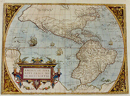
Title: AMERICAE SIVE | NOVI ORBIS, NO:|VA DESCRIPTIO. [A New description of America or the New World]. (lower right:) "Cum priuilegio" [with privilege]. Texts on map middle left: "NOVA GUINEA, Andre:|as Corsalis Florent: videtur eă| sub nomine Terrć Piccinacoli| designare". [New Guinea, Andrea Corsali from Florence seems to refer to it under the name Terra Picciacoli]. Left top: "Vlterius Septentrionem versus hć | regiones incognitć adhuc sunt". [Further North these regions are until now unknown]. Middle left: "Hć duć insulć infortunatć sunt dictć | ŕ Magellano, quod nec homines nec|victui apta haberent". [These two islands are called the unfortunate ones by Magalhaes because they have neither inhabitants nor food]. Middle center: "Hic vspiam insulas | esse, auro diuites | nonnulli | uolunt". [Somewhere here there are islands which according to some have gold]. Lower right: "PATAGONVM REGIO, vbi incolć | sunt gigantes". [The area of Patagonia, where the inhabitants are giants.] Lower right: "Rio Maragnone | cuius ostiam distat | ab ostio Amazonis | fl. 104. leucis teste Theueto". [The river Maranhao of which the mouth is at a distance of 104 miles from the mouth of the river Amazon, according to Thevet]. Middle right: "BRESILIA | a Lusitanis Ao. | 1504. | inuenta". [Brazil, discovered by the Portuguese in 1504]. Middle right: "Porto real ad quem | Galli mercatum | nauigant". [Royal Porto Real to which the French sail for trade].
Plate size: 366 x 506 mm
Scale: 1 : 40,000,000
Identification number: Ort 9 (Koeman/Meurer: 2, Karrow: 1/7, van der Krogt AN: 9000:31A)
Occurrence in Theatrum editions and page number:
1570L(AC)2 (225 copies printed) (12th textline from the bottom ends: vtplu-; last line before two column list: rimum ...extant; last line first column: ANTONIVS MENDOZA, last line second column: IOANNES STADENSIS Germanicč.),
1570L(B)2 (100 copies printed) (last line before two column list: mum ... extant.),
1571L2 (275 copies printed) (12th textline from the bottom ends: vtpluri-; last line before two column list: mum ...extant; last line, first column: ANTONIVS MENDOZA, last line second column: IOANNES STADENSIS Germanicč.,
1571/1573D2 (350 copies printed) (last line, in cursive script, centred like the line above it: "van ghedaente seer nae eens kemels,was rosch van verwe".),
1572/1574F2 (225 copies printed), (last line, centred like 3 lines above it: pres d'vn Chameau, estant de couleur rousse.),
1571/1572G2Koler (pasted over p.2 of a 1571L edition; few copies printed) (last line in four columns: Diegus Godoyus. Antonius Mendoza, Americus Vespucius, Iohannes Stadensis, (in Gothic script:) Teutsch.),
1572/1573G2, (225 copies printed) (last line, centred: der grosse ains esels,vń gestalt ains khemelthiers;es vvar rőttlet von farben.etc.),
1573L(AB)2 (75 copies printed) (Version A has 19th line ending with: rege: ; version B has 19th line ending with: Rege. ; second line of text in both versions begins: uus orbis),
1574L2 (175 copies printed) (large page number, 11 mm; second line of text begins: uus , last line, left column ANTONIVS MENDOZA, right column: IOANNES STADENSIS Germanicč),
1575L2 (100 copies printed) (small page number, 7 mm; second line of text begins: "Nouus Orbis", last line, left column: ANTONIVS MENDOZA, right column: IOANNES STADENSIS Germanicč).
Approximate total number of copies printed: 1750.
States: (as described)
2.1. In 1570L, the Azores are erroneously called "Canarić insule".
2.2 From 1571L onwards, this is corrected to "Las Açores".
2.3 In 1575, among the longitude grade scale at the top of the map, the 230 value has been erased.
Cartographic sources: Gerard Mercator's 1569 world map (Koeman/Meurer :2, Karrow: 56/17, 56/18 p. 390-393, Meurer p. 38).
References: Ph. D. Burden, "The Mapping of America 1511-1670", 1999, p. 51, map 39. D. Reinhartz "The Americas Revealed in the Theatrum", p. 209-220 in: Van den Broecke, Van der Krogt and Meurer (eds) "Abraham Ortelius and the First Atlas", HES Publishers, 1998.
Remarks:
Note that the sea area South-West of Brazil contained a picture (probably a ship) which was erased before the first copy of this map was published in 1570. The dot pattern, which is normally vertical in the seas, is random in this area, and the edges still contain wave patterns.
This map is replaced from 1579 onwards by plate 10. That plate is very similar to the present one, but the ships are different. The leftmost ship in plate 10 no longer shows its sails bulging towards the viewer, but rather allows the viewer to look into the sails. The frame of plate 10 no longer contains a clear chain-like structure with largish eyes and links typical of this plate number 9, but small unconnected circle-like figures.
As the first depiction of the Americas in a regular atlas, this map is of fundamental importance. It is amazing how well the Western Hemisphere is depicted, considering that it appeared only 78 years after Columbus discovered America.
The poem included in the text below beginning with "Saxa volventur" (paragraph 18-21) also occurs in the "Paraphrase de Galien" written by Michel de Nostre Dame.
For questions/comments concerning this page, please e-mail info@orteliusmaps.com.