Cartographica Neerlandica Background for Ortelius Map No. 7
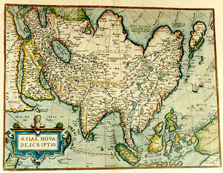

image of the map

Title: ASIÆ NOVA|DESCRIPTIO [A New Depiction of Asia]

Plate size: 376 x 489 mm
Scale: 1 : 28,000,000
Identification number: Ort 7 (Koeman/Meurer: 93/I should be 71/I, not in Karrow, van der Krogt AN: 8000:31B)

Occurrence in Theatrum editions and page number:
most 1574L3 (175 copies printed) (last line, centred like 2 lines above it: nem in maiori Tabula ante tres annos edidimus.),
1575L3 (100 copies printed) (first text line ends: tracta ad; last line, centred: Nos quoque eius descriptionem in maiori Tabula ante tres annos edidimus.),
1579LA3 (250 copies printed) (first textline ends: tracta ad Gran-; last line, centred: Nos quoque eius descriptionem in maiori Tabula ante tres annos edidimus. Initial N of this line below rc of previous line.),
1579LB3 (250 copies printed) (first textline ends: tracta ad Gran-; last line, centred: Nos quoque eius descriptionem in maiori Tabula ante tres annos edidimus. Initial N of this line below au of previous line.),
1580/1589G3 (350 copies printed) (last line, centred like 5 lines above it, in Gothic script: in Truck verfertigt.),
1581F3 (400 copies printed) (last line, left aligned, in cursive script like the entire text: "te)si c'est une Isle ou terre ferme auec la Magellanique".),
1584L3 (750 copies printed) (first textline ends: Gran- ; last line, centred unlike any other line: Nos quoque eius descriptionem in maiori Tabula ante tres annos edidimus.),
1587F3 (250 copies printed) (last line, left aligned, in cursive script: "Isle ou terre ferme auec la Magellanique."),
1588S3 (300 copies printed) (last line, centred: Nos tambien hemos facado a luz agora ha tres años la description d'ella en tabla mayor.),
1589G3 see 1580G
1592L3 (525 copies printed) (first textline ends: ad ; last line, indented, centred: Nos quoque eius descriptionem in maiori Tabula ante aliquot annos edidimus.),
1595L3 (500 copies printed) (first textline ends: tracta ; 15th line ends: quem in- ; last line, indented, centred: Nos quoque eius descriptionem in maiori Tabula ante aliquot annos edidimus.),
1598/1610/1613D2 (100 copies printed) (last line, left aligned, in Gothic script like the entire text: Magellanicais.),
1598F3 (525 copies printed) (last line, left aligned: descouuerte )si c'est vne Isle ou terre ferme auec la Magellanique.),
1601L3 (200 copies printed) (first textline ends: tracta ; 15th line ends: quem ; last line, indented: Nos quoque eius descriptionem in maiori Tabula ante aliquot annos edidimus.),
1602G3 (250 copies printed) (last line, centred like 6 lines above it, in Gothic script: fertigt.),
1602S3 (250 copies printed) (last line, left aligned, small indentation: Nos tambien hemos facado a luz agora ha tres años la descripcion d'ella en tabla mayor.),
1603L3, (300 copies printed) (last line, centred: Nos quoque eius descriptionem in maiori Tabula ante aliquot annos edidimus. Note that this text and page number are identical to the text of the 1609/1612L edition, but the typesetting is different; the page number 3 is 3/4 to the right, whereas the 1609/1612 is 2/3 to the right),
1606E3 (300 copies printed) (last line, italic like the entire text, centred: "I myselfe likewise certaine yeeres past set forth in a large Map the description of the same."),
1608/1612I3 (300 copies printed) (last line, left aligned: habbiamo dato in luce il suo dissegno in tauola maggiore.),
1609/1612/1641S3 (325 copies printed) (last line, indented: Nos tambien hemos facado a luz agora ha tres años la description d'ella en tabla mayor.),
1609L/1612L3 (300 copies printed) (last line, centred: Nos quoque eius descriptionem in maiori Tabula ante aliquot annos edidimus. Note that this text and page number are identical to that of 1603L, but the typesetting is different; the page number 3 is 2/3 to the right, whereas it is in 1603L 3/4 to the right).

Approximate total number of copies printed: 6700.

States: we know 7.1 only. From 1608 the map displays a spurious line running from the East of Java Maior to the West coast of Sumatra, ending above Ticos.

Cartographic sources: Ortelius' own 1567 wall map of Asia, based in turn on work by Gastaldi and Albufeda (Karrow 1/4, 30/85, 30/91 and 30/92, Meurer p. 21).

References: Tibbets, Arabia in Early Maps, Falcon-Oleander, 1978, map 41, p. 52-53. On Ortelius wall map of Asia, see G. Schilder "The Wall Maps by Abraham Ortelius" p. 93-124 and M. Heintz & C. Reiter "Asiæ Descriptio and the Judgment Day Painting", p. 125-132, both in: Van den Broecke, van der Krogt and Meurer (eds) "Abraham Ortelius and the First Atlas", HES Publishers, 1998. T. Suarez, Early Mapping of South-East Asia, Periplus,1999, p. 164-170.

Remarks: This plate is very similar to the first Asia plate, but does not have the faint "Cum priuilegio" in the lower left corner. "La Farfana" in the upper right corner in the sea has capital first letter on the first plate (Ort 6) but is in lower case "farfana" in the second plate (Ort 7). The town "Ara" above "Aden" has disappeared in the second plate.

The texts of this map closely resemble those of its predecessor, Ort6. Texts: 2 (scientific version, translated from the 1574 Latin, 1575 Latin, 1579 Latin, 1580/1589 German, 1584 Latin, 1587 French, 1588 Spanish, 1592 Latin, 1595 Latin, 1598 French, 1598 Dutch, 1601 Latin, 1602 German, 1602 Spanish, 1603 Latin, 1606 English, 1608/1612 Italian, 1609/1612/1641 Spanish and 1609/1612 Latin edition; we will first present the Latin, late German and Spanish editions, and then the French, early German and Dutch editions).

7.1. {1574L{ASIA

7.2. Asia is separated from Europe through the river Don [Tanais], and by a {1602S, 1606E and 1609/1612/1641S only{straight}1602S, 1606E & 1609/1612/1641S only}line drawn from the sources of that river to {1580/1589G & 1602G only{the harbour of}1580/1589G & 1602G only} Grandvicum {1606E instead:{the Bay of St. Nicolas}1606E instead} towards the Northern Ocean; from Africa by the small piece of land or isthmos between the Arabian Gulf {1608/1612I only{or Red Sea}1608/1612I only} and the Mediterranean sea. The remainder of the continent is surrounded by the ocean and by other seas.
7.3. The ancient geographers {1595L, not in 1602G{such as Strabo in his eleventh book and Arrianus in his fifth book}1595L, not in 1602G} have divided it in various manners. But presently it may not be unreasonable to say that it is distributed over five parts, according to the empires by which it is governed. The first of these borders on Europe, subject to the great Duke of Muscovy, is bounded by the frozen sea, the river Ob, lake Kytaia, and a {1580/1589G & 1602G only{straight}1580/1589G & 1602G only} line drawn from there to the Caspian sea, and by the isthmus, {1606E only{or neck-land}1606E only} between the Caspian and the Black sea. The second one is that which yields obedience to the great Cham, Emperor of the Tartars, of which the Southern borders are the Caspian sea, the river Iaxartes, and mount Imaus [the Himalayas]; on the East and North it is bordered by the ocean, and Westwards it is bound by the kingdom of the great Duke of Russia just mentioned. The third part, the area occupied by the clan of the Ottomans {1606E only{or the Turkish Emperor,}1606E only} contains whatever regions are situated within the Black sea, {not in 1580/1589G & 1602G{the Aegæan sea (now called Archipelago)}not in 1580/1589G & 1602G}, the Mediterranean sea, Egypt, {1580/1589G & 1602G only{the harbours of}1580/1589G & 1602G only} the Arabian and Persian gulfs, the river Tigris, the Caspian sea, and the isthmos {1606E only{or stretch of land}1606E only} which can be seen between the Caspian and the Black sea. Under the fourth shall be comprised the Kingdom of Persia, now governed by the Sophies.
7.4. Westwards, it has the Ottomans just mentioned, with whom the Persians maintain continual warfare; Northwards the Empire of the great Cham; Eastwards it extends almost to the river Indus; and on the South it is washed by the sea, presently called Indicum, but in former times Red Sea [Mare Rubrum]. Now, the fifth part takes up all that remains, which, in the past as well as in the present is called the Indies; they are not governed by one king, as are the former, but by many petty kings, almost every region having its particular governor, some of whom are subjected by or tributaries to the great Cham. And it is not to be omitted that all the sea coasts from the Arabian Gulf to this promontory {1606E only{of China,}1606E only} commonly called Cabo de Lampo, which can be seen at 30 degrees of Northern Latitude, are owned, or made tributaries to the Portuguese.
7.5. Among an infinite number of other islands, the principal ones belonging to Asia are Crete {1595L, 1601L, 1603L, 1606E, 1608/1612I & 1609/1612L instead{Cyprus}1595L, 1601L, 1603L, 1606E, 1608/1612I & 1609/1612L instead} and Rhodes in the Mediterranean sea; then Taprobana and Ceylon [Zeilan], {1606E only{well known to the ancients, now called Samotra, but incorrectly also Sumatra,}1606E only} in the Indian Ocean, where also, within the memory of our fathers, the Portuguese have discovered the two Javas, with {1606E only{the isles of}1606E only} Borneo, Celebes, Palohan, and Mindanao, Gilolo with the Moluccas, now famous for their spices. Then the isles of Japan and New Guinea, discovered lately, but whether this last one is an island, or is joined to the antarctic mainland is not known.
7.6. The history of this part of the world is one of great fame, not only through {1608/1612I only{ancient}1608/1612I only} profane writers (as they call them), with respect to the first monarchies in the world as established by the Assyrians, the Persians and the Babylonians, and the Medes; but it is also more famous in the Holy Writings than is the rest; for here mankind was not only created by the great almighty God, deluded and corrupted by the enemy satan, and restored by our Saviour Christ, but we also read that almost all histories in either testament have been fulfilled and have been written down in this part of the world.
7.7. Strabo has described Asia in six books, namely from book 11 onwards {1606E only{to book 16}1606E only}. Ptolemæus has described the same in three of his books namely book 5, 6 and 7, and likewise in 12 geographical maps, and he attributes 40 provinces to it. {1592L, not in 1602G{It has also been described by Ammianus Marcellinus in his 23rd book}1592L, not in 1602G}, {1579LAB{and by Diodorus Siculus at the beginning of his 18th book}1579LAB}. Of recent writers none have fully and specifically described it. Mr. Paulus Venetus {1608/1612I only{Marco Polo of Venice}1608/1612I only}, Ludovicus Vartomannus {1606E & 1608/1612I instead{Barthema}1606E & 1608/1612I instead}, and John Mandeville, (but this last author is full of fables) have written much about it as they found worthy of observation by travelling through the area. Read also the Epistle of Jacobus Navarcha, a Jesuit.
7.8. We have likewise published a large map describing Asia three {1592L and later except 1602G, 1602S and 1609/1612/1641S have instead:{some}1592L & later except 1602G, 1602S & 1609/1612/1641S instead} years ago}1574L, 1575L, 1579L(AB), 1580/1589G, 1584L, 1588S, 1592L, 1595L, 1601L, 1602G, 1602S, 1603L, 1606E, 1608/1612I, 1609/1612L & 1609/1612/1641S end here}. [The last remark refers to Ortelius' 8-sheet wall map of Asia, published in 1567].

[Since the text of the 1581 French, 1587 French, 1598/1610/1613 Dutch and 1598 French editions are different from the one given above, a separate translation of this popular text is given below]

7.9. {1581F{Asia.

7.10. In all writers this part of the world, after {1598D instead{next to}1598D instead} Europa, has been very famous because of the Persian, Medan, Assyrian, and Babylonian monarchies etc. But above all, much has been written about it in the Holy Script, since the human race was first created there, betrayed by the devil and fallen, and resurrected and saved by Jesus Christ. In summary, the entire history related in the Old Testament took place in this part of the world.
7.11. The ancient writers have divided this continent into many different parts, but nowadays it seems appropriate to divide it into five parts after the main five empires or monarchies. The first of which, adjacent to Europe, belongs to the Duke of Muscovy; it is confined by the Northern sea, the river Ob, lake Kytaia, and a line drawn from there to the Caspian sea, and the Isthmus or narrow piece of land which is found between this Caspian sea and the Black sea [Mar Magiore].
7.12. The second empire is that which is subject to the Great Cham, which borders on the first one on its West; in the South on the river Chesel, Mount Imaus [the Himalayas] and from there (roughly) by a line going to the sea near Cabo de Lampo; in the East and the North it is bordered by the sea.
7.13. The third Empire is that tyrannised by the great Turk. It is enclosed by the Black Sea [Mar Magiore], the Archipelago, the Mediterranean, Egypt, the Red Sea, the Sea of the Persians, the river Tigris, the Caspian Sea, and the narrow piece of land between this Caspian Sea and the Black Sea [Mar Magiore].
7.14. The fourth shall be the kingdom of the Persians, ruled by the Sophies, which in the West borders on the land of the Turks just mentioned, in the North on the kingdom of the Great Cham, in the East it extends almost to the river Indus, and in the South it is bordered by the Indian Sea.
7.15. The fifth part shall comprise all that remains, which is now known and has been known before as the Indies. But this part is not governed by one single ruler, as the others are, but by numerous different rulers, because each specific country here has its own specific lord, some of whom are subject or pay tribute to the Great Cham.
7.16. Also, we should not remain silent about the fact that all ports or harbours and fortifications which border on the sea from the Red Sea all the way to Cabo de Lampo (which is located thirty degrees North of the Equator), are all in possession of the King of Portugal, or at least pay tribute to him.
7.17. To this continent of Asia also belong many large and rich islands, among which are included, going from West to East, excepting Cyprus and Rhodes, which are situated in the Mediterranean, these as most noteworthy: Ceylon [Zeylan], which produces the best cinnamon, Sumatra [Samotra], Java the large and the small one, Borneo, Celebes, Palohan, Mindanao, Gilolo with the Moluccas yielding cloves, and Japan, which will later be described in detail, as also New Guinea, which, because it has not yet been explored, is not known to be an island or part of the continent of Magellanica}1581F, 1587F, 1598F & 1598/1610/1613D end here}.

Bibliographical sources mentioned in this text:

Arrianus : Bk.5 7.3
Holy Script 7.6, 7.10
Mandeville, Ioannes 7.7
Marcellinus, Ammianus : Bk.23 7.7
Navarcha, Jacobus, the Jesuit : Epistle 7.7
Ortelius : 8-sheet wall map of Asia made in 1567 7.8
Ptolemæus : Bk.5-7, 12 maps 7.7
Siculus, Diodorus : Bk.18 7.7
Strabo : Bk. 11 7.3; Bk. 11-16 7.7
Vartomannus, Ludovicus 7.7
Venetus, Paulus 7.7

No map text available

No bibliographical sources available

Topographical names


For questions/comments concerning this page, please e-mail info@orteliusmaps.com.
The software that generates this website is available for sale. For more information, contact Thomer M. Gil.
This page has been generated on Sat Dec 22 13:15:53 2007.