Cartographica Neerlandica Background for Ortelius Map No. 65
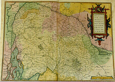
Title: BRABAN:|TIĆ, GER:|MANIAE | INFERIO:|RIS NOBI:|LISSIMĆ | PROVIN:|CIĆ DE:|SCRIPTIO. "Jacobo ŕ Daventria | auct". [A representation of Brabant, a most noble province of Lower Germany, made by Jacob van Deventer]. (Bottom, left of centre:) "Cum priuilegio." [With privilege].
Plate size: 365 x 504 mm
Scale: 1 : 400,000
Identification number: Ort 65 (Koeman/Meurer: 16, Karrow: 1/24, van der Krogt AN: 3100:31A)
Occurrence in Theatrum editions and page number:
1570L(A)16 (100 copies printed) (second text line ends: attingat,; last line, centred like 6 lines above it: illustravit ; full stop after title diamond shaped),
1570L(B)16 (100 copies printed) (second text line ends: attin-; full stop after title diamond in shape; last text line, centred like 6 lines above it: illustrauit.),
1570L(C)16 (125 copies printed) (second text line ends: attingat, ; full stop after title round in shape, last text line, centred like 6 lines above it: illustrauit.),
1571L16 (275 copies printed) (second text line ends: attin-; full stop after title round in shape, last line, centred like 6 lines above it: illustrauit.),
A variant with page number 16 and cursive script throughout, second line ends with cursive "attingit" exists, the map which already shows the second state, and which was introduced after 1572/1573G and before 1573L.),
1571/1573D16 (350 copies printed) (last line, in Gothic script like the entire text, centred like 3 lines above it: Lande van Valcken-borch:Dalem/&c.),
1572G16Koler (pasted over p.16 of a 1570L edition; few copies printed)(last line, left aligned, in Gothic script: nitzen du in diser Tabul sehen kanst) beschriben.),
1572/1573G16 (225 copies printed) (last line, cursive like the entire text, centred like 4 lines above it: "das Land von Valckenburg: Dalem,etc".),
1572/1574F16 (225 copies printed) (last line, centred like 2 lines above it: appertenants sous ceste Duché de Brabant.),
1573L(AB)20 (75 copies printed) (in 1573L(A): last line, centred like 6 lines above it: illustrauit; non-cursive like the entire text; in 1573L(B): last line cursive like the entire text, centred like 6 lines above it: "Commentarijs illustrauit."),
1574L20 (175 copies printed) (large page number, 11 mm; title followed by a round dot; 10th line from the top ends: "Bergis Ducatum" ; last line, centred like 6 lines above it, in italic script like the entire text: "Commentarijs illustrauit".),
1575L20 (100 copies printed) (small page number, 7 mm; title followed by diamond-shaped dot; 10th line ends: "Bergis, Ducatum" ; last line, centred like 6 lines above it, in italic script like the entire text: "Commentarijs illustrauit.")
1579L(A)28 (250 copies printed) (last line, left aligned, in cursive script: "berti Leodij, de Tungris & Eburonibus."),
1579L(B)28 (250 copies printed) (last line, left aligned, in cursive script: "tabula habetur,videatur opusculum Huberti Leodij,De Tungris & Eburonibus".),
1580/1589G28 (350 copies printed) (last line, centred like 5 lines above it, in Gothic script like the entire text: Eburonen.),
1581F28 (400 copies printed) (last line, left aligned, begins: nants sous ceste Duché de Brabant.),
1584L34 (750 copies printed) (last line, in italic script like the entire text, left aligned: "Ioannis Goropij Becani Becceselana".),
1587F34 (250 copies printed) (last line, left aligned: appertenants sous ceste Duché de Brabant.),
1588S34 (300 copies printed) (last line, left aligned: guamente los Aduaticos : mira acerca d'ello a Ioan Goropio Becano en sus Beccesellanas.),
1592L36 (25 copies printed?), few copies,
1603 (Vrients1) contains this map but without text or page number.
Approximate number of copies printed: 4825.
States: 65.1 see above. Also copies included after 1592, see below.
65.2: from 1573L(B) onwards of the two rivers Aade east and south of 's Hertogenbosch, the south one is renamed "De Runne fl." The "nieu Vaart" between Brussels and Willebroek runs West of Vilvoorde in state 1, but East of Vilvoorde, which is newly engraved, in state 2.
65.3: post-1612S now with "Th. Galle excud." added. Numerous other small changes. Wrongly, "7. merren" is changed to "2 merren"; "S. Andries" is added South of "Bueren; Herw:|erden" is re-engraved as "Her|werden" and a fort is added; "Loevensteyn" is added South of "Asperen"; "Clun:|der" and "Willem|stadt" are added; the island PRINCEN LANDT is added South of Voorn; "Tsgrauen wwert, in qua | Schenken schans." is added South of "Cleve"; the name of the river "Schelde" is erased West of Antwerp and "Liefkens|hoeck" with some fortifications is inserted instead;.
65.4: post-1612S: "Th. Galle excud." covered or erased. States 3 and 4 have so far not been found in an atlas edition.
I am grateful to Mr. Mathieu Franssen for pointing out some of these states.
Cartographic sources: Based on the six-sheet Brabant map with North at the top of Jacob van Deventer (1500-1575), published in 1536, and reprinted in Antwerp in 1558 by Arnold Nicolai (Meurer p. 137-138, Karrow 25/1 p. 143-144).
References: H.A.M. van der Heijden "Ortelius and the Netherlands", p. 271-290 in: M. van den Broecke, P. van der Krogt and P. Meurer (eds.) "Abraham Ortelius and the First Atlas", HES Publishers, 1998
Remarks: From 1595L onwards replaced by plate Ort 66, which has an inset. Yet, the present plate was not discarded. In Vrients (1603) and post-1612S prints we find it again.
For questions/comments concerning this page, please e-mail info@orteliusmaps.com.