Cartographica Neerlandica Background for Ortelius Map No. 62
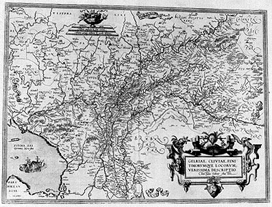
Title: GELRIAE, CLIVIAE, FINI:|TIMORVMQVE LOCORVM | VERISSIMA DESCRIPTIO | "Christiano Schrot Auctore" [A very true representation of Gelderland, Cleve and bordering locations by Christian Schrot]. (bottom left corner:) "Cum priuilegio" [with privilege].
Plate size: 372 x 500 mm
Scale: 1 : 400,000
Identification number: Ort 62 (not in Koeman, Meurer or Karrow, van der Krogt AN: 3700:31B)
Occurrence in Theatrum editions and page number:
few 1579L(B)27 (50 copies printed?) (last line, centred like 2 lines above it: apud Guicciardinum in sua Germania inferiore.),
few 1584L32 (50 copies printed?)
1592L34 (525 copies printed) (last line, centred like two lines above it: inuenies apud Guicciardinum in sua Germania inferiore.),
few 1612L42 (25 copies printed?).
Possibly some copies in intermediate editions as well.
Approximate number of copies printed: 650
States: 62.1 only.
Cartographic sources: Christiaan Sgrothen (abt. 1520-1608) mapped German and Dutch Geldria and Cock published his map of it in 1567 (Meurer p. 237-238, Karrow 70/2 p. 480-481).
References: J.J. Vredenberg-Alink (1975) "Kaarten van Gelderland en de Kwartieren". Zutphen, de Walburg Pers. H.A.M. van der Heijden "Ortelius and the Netherlands", p. 271-290 in: M. van den Broecke, P. van der Krogt and P. Meurer (eds.) "Abraham Ortelius and the First Atlas", HES Publishers, 1998
Remarks: this plate differs from plate Ort 61 in that it has two war ships rather than one ordinary ship. No painters' instruments around the cartouche any more. "BRABANTIĆ PARS" is in cursive rather than straight capitals. Apparently, for reasons unknown, this plate existed side by side with Ort61 from as early as 1579 onwards. Its text is that of the Ort61 plate.
For questions/comments concerning this page, please e-mail info@orteliusmaps.com.