Cartographica Neerlandica Background for Ortelius Map No. 45

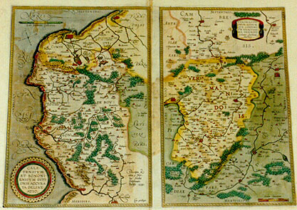
Title: CALE:|TENSIVM | ET BONONI:|ENSIVM DITI:|ONIS ACCVRA:|TA DELINE:|ATIO. [An accurate representation of the area of Calais and Boulogne] (Bottom right) "Cum priuilegio". [With privilege]. (Lower right:) "Descripta & | edita a Nico:|lao Nicolai Delphinate | Parisijs 1558". [Drawn up and edited by Nicolaus Nicolai Delphinatis from Paris 1558]. (Middle left:) "Toute la fosse de Boullonnois a | de circuit 26. lieues". [The entire Boulogne stream has a circumference of 26 miles.] - VEROMANDV:|ORVM EORVM:|QVE CONFINI:|VM EXACTISSI:|MA DESCRIPT. | "Iohanne Surhonio | Auctore". [A most exact representation of Vermandois and its borders by Iohannes Surhonius].
Plate size: 343 x 467 mm. Two maps on one plate.
Identification number: Ort 45
Title 45a: Caletensium
Scale: 1 : 200,000. Size: 343 x 236 mm.
Identification number: Ort 45a (Koeman/Meurer: 139a, Karrow: 1/17a, van der Krogt AN: 4120:31B).
States: 45a.1 as described.
45a.2: date removed in 1612S or later.
Progressive damage of lower left corner of copperplate.
Cartographic sources: Nicolas de Nicolay (1517-1583) published a 4-sheet map of the area between Boulogne and Calais in 1558 in Paris (Meurer p. 207-208, Karrow 59/5 p. 438)
Title 45b: Veromanduorum
Scale: 1 : 200,000. Size: 343 x 217 mm.
Identification number: Ort 45b (Koeman/Meurer: 139b, Karrow: 1/18a, van der Krogt AN: 4160:31B).
States: 45b.1 only.
Cartographic sources: Jean de Surhon received royal privilege in 1557 to make a map of Vermandois. It was published a year later in Antwerp by Arnold Nicolai (Meurer p. 251, Karrow 74/2, p. 517-518).
Occurrence in Theatrum editions and page number:
most 1598/1610/1613D21 (75 copies printed) (last line, centred like 3 lines above it, italic: "beghinsel nemen".),
1598F23 (525 copies printed) (last line, left aligned: prennent leur commencement non gueres loin les vnes des autres.),
1601L26 (200 copies printed) (last line, left aligned: liĉ Belgicĉ.),
1602G29 (250 copies printed) (last line, centred like 4 lines above it, in Gothic script like the entire text: men Belgica gedeutet wirt.),
1602S29 (250 copies printed) (last line, left aligned but almost full width: sententia de Pedro Diuĉo,en su librito de las antiguedades de la Gallia Belgica.),
1603L29 (300 copies printed) (last line, left aligned: de iis populis sententiam Petri Diuĉi, in libello Antiquitatum Galliĉ Belgicĉ.)
1603D (Vrients1) no text nor page number,
1606E26 (300 copies printed) (last line, left aligned, cursive unlike most of the text: "gica".),
1608/1612I32 (300 copies printed) (last line, in cursive script like the entire text, left aligned: "riore , & di quel l'altre regioni à lei congiunte."),
1609/1612L31 (300 copies printed) (last line, left aligned: tatum Galliĉ Belgicĉ.).
1609/1612/1641S31 (325 copies printed) (last line, left aligned: dades de la Gallia Belgica.),
Approximate number of copies printed: 2825.
Remarks: Replaces plate Ort 44, where Vermandois has South at the top.
For questions/comments concerning this page, please e-mail info@orteliusmaps.com.