Cartographica Neerlandica Background for Ortelius Map No. 23
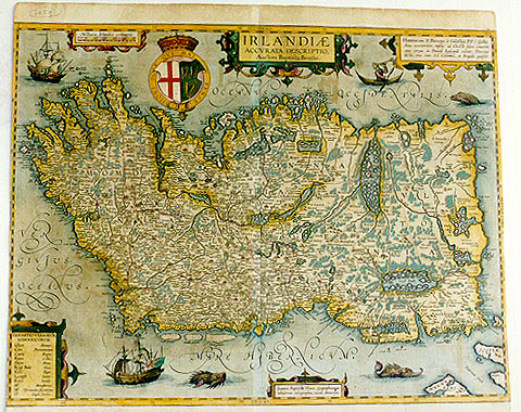
Title: IRLANDIĆ | ACCVRATA DESCRIPTIO, | Auctore Baptista Boazio. [an accurate depiction of Ireland] (around shield:) HONI SOIT QVI MAL Y PENSE. [Shame on who thinks evil about this] (cartouche centre bottom:) "Ioannes Baptista Vrints, Geographicarum | tabularum calcographus, excud. Antverpić". [Ioannes Baptista Vrients, designer of geographical maps made this map in Antwerp] (cartouche top right corner:) "HIBERNIAM S. Patricius ŕ Cślestino PP. č Gallijs | Anno CCCCXXXIII. missus ad Christi fidem convertit, | cuius corpus in Dunensi Episcopali civitate, DOVVNE | dicta, una cum SS. Columba, et Brigida quiescit". [The Holy Saint Patricius from France was sent here by Pope Celestinus in the year 434 to convert Ireland to the Christian faith whose body rests in the Episcopate of Downe together with those of the Saints Columba and Brigida] (cartouche bottom left corner: EXPOSITIO VERBORVM | HIBERNICORVM.[A list of Irish words]|Glyn "Nemus." [wood]| Can "Promontorium." [Cape]| Caric "Rupes." [Rock]| Knoc "Collis." [Hill]| Slew "Mons." [Mountain]| B. vel Bale "Vicus." [City]| Kill "Pagus." [Village] Lough "Lacus." [Lake]| Enis "Insula." [Island]| Mo. "Monasterium." [Monastery]| O. "Caput familić." [Head of a family]).
Plate size: 441 x 579 mm.
Scale: 1 : 2,000,000
Identification number: Ort 23 (Koeman/Meurer: 149, not in Karrow, van der Krogt AN: 5900:31B).
Occurrence in Theatrum editions and page number:
few 1603Lblank(?)
1606Exlj (300 copies printed) (last line, left aligned: satisfie thee to the full.) ,
1608/1612I14 (300 copies printed) (last line first text page, right aligned: co ; last line second text page, left aligned: ritornati, le cui visioni sono dalli predetti frati scritte, & mostrate a coloro, che entrarui vogliono.),
1609/1612/1641S14 (325 copies printed) last line first text page, right aligned: da veras ; last line second text page, in cursive script like the bottom half of this page, left aligned: "muestran a los que quieren entrar en ella."),
1609/1612L14 (300 copies printed) (last line, left aligned, small font: ibi perierunt,multi etiam reuersi sunt,quorum visiones ŕ prćdictis fratribus conscriptć sunt, & volentibus intrare ostenduntur.).
Approximate number of copies printed: 1325.
States: 23.1a has a dedication to James I in the upper right hand cartouche. In 23.1b, the second variant of this state, a printed paste-over obliterates this reference.
23.2: the state described in the title above. It applies to some 1606E, most 1608I and all 1609L and later editions. The second state has a reference to St. Patrick as given above.
23.3: State 3, post 1612S has the name of Galle added (copy in the Municipal Library of Braunschweig).
Cartographic sources: a derivative of the large Boazio Ireland map engraved by Elstrach and published by Sudbury in 1599.
References: J.H. Andrews (1970) Baptista Boazio's map of Ireland, Long Room no. 1; Andrew Bonar Law (1983) "The Printed Maps of Ireland to 1612", and Andrew Bonar Law (1997) "The Printed Maps of Ireland, 1612-1850", The Neptune Gallery, Dublin, ISBN 0-9532241-0-4, p. 305. A. Kelly "Maps of the British Isles, England and Wales, and Ireland", p. 221-238, (who first established the states described above) in Van den Broecke, van der Krogt & Meurer (eds.) "Abraham Ortelius and the First Atlas", 1998, HES Publishers.
For questions/comments concerning this page, please e-mail info@orteliusmaps.com.