Cartographica Neerlandica Background for Ortelius Map No. 227
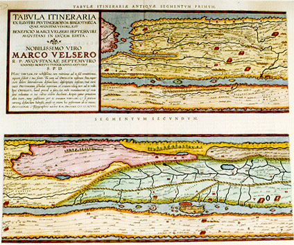
Title: TABVLA ITINERARIA | EX ILLVSTRI PEVTINGERORVM BIBLIOTHECA | QVAE AVGVSTAE VINDEL. EST | BENEFICIO MARCI VELSERI SEPTEMVIRI | AVGVSTANI IN LVCEM EDITA. | NOBILISSIMO VIRO | MARCO VELSERO | R.P. AVGVSTANAE SEPTEMVIRO | IOANNES MORETVS TYPOGRAPHVS ANTVERP. | S.P.D. | "HANC TABVLAM, Vir nobilißime, non mittimus ad te, sed remittimus, | aquam scilicet č tuo fonte. Tu eam ad ORTELIVM nostrum (heu, nupe r| cum dolore litteratorum defunctum) descriptam miseras, tuâ curâ | inter PEVTINGERI schedas repertam et erutam: ideoque iure ad te redit. | Ipse ORTELIVS, haud procul a fato, ita mihi mandaverat: & mea | sane voluntas et tui cultus eôdem ducebant. Accipies igitur priuatam | olim tuam, nunc publicam per te omnium TABVLAM: & si gratum | carumque defunctum habuisti, qućso vt etiam hoc postremum ab eo munus. | ANTVERPIĆ č Typographeio nostro". KAL. DECEMB. M.D.XCVIII. [Road map from the famous library of the family Peutinger from Augsburg in Bavaria, brought to light by Marcus Welser from Augsburg, belonging to the council of seven. Joannes Moretus, publisher in Antwerp, dedicates this map to the very noble gentleman Marcus Welser. This map, very noble lord, is not being sent to you by us, but is returned, water as it is from your fountain. You have sent its design to our Ortelius (who alas, to the misery of all literary people, is now deceased), after it had been located and found back by your diligence between the manuscripts of Peutinger, and therefore it is rightfully returned to you. Ortelius himself has ordered me to do so, shortly before he died; and both my own desire as well as my respect for you prompted me towards this goal. You will therefore receive this map, once your private property, now through you public property of everyone. And as much as the deceased was dear to you, I hope that this last present from him will be equally dear to you. Antwerp, by our typographer (Plantin-Moretus) First of December 1598.] (This is the first sheet of the set of four, and contains segments one and two).
Plate size (2 plates): (top:) 193 x 516 mm, (first state only:) A engraved at midbottom; (bottom:) 193 x 516 mm. Two (potentially adjacent) maps on two plates.
Scale: not applicable.
Identification number: Ort 227 (Koeman/Meurer: 44P, not in Karrow, van der Krogt AN: 0910:1:31).
Occurrence in Theatrum editions and page number:
1619BertiusII, (200 copies printed) (last line first text page, centred: PRIMVM ET SECVNDVM. (see further below),
1624P/1641Sxliij (1025 copies printed) (last line first text page, in two columns; first column: diciis liquet. Hćc cům ad manumeas Second column: que non pauca paucis, sine ostenta-|tione).
Approximate number of copies printed in the Theatrum: 1225.
States: 227.1 only. However, the text has three states:
-The first text state occurs in a few separately printed Peutinger maps of 1598. These sheets have no text on verso and no texts above the 8 map strips on the four map sheets Ort227-Ort230.
-The second text state occurs in Bertius' 1618/1619 atlas Theatri Geographiae Veteris Tomus Posterior, page II, 1619, text in two columns, last line first text page, second column, left aligned: "cessoribus nostris relinquamus". Text above first map strip: TABULĆ PEVTINGERIANĆ SEGMENTVM PRIMVM, "ab ostiis Rheni Bonnam vsque". Text above second map strip: SEGMENTVM SECVNDVM "ŕ Bonna ad Marcomannos".
-The third text state occurs in the 1624Latin Parergon/1641 Spanish edition, but text in Latin, last line first text page, second column, right aligned: tione, ; text above first map strip: TABVLĆ ITINERARIĆ ANTIQVĆ SEGMENTVM PRIMVM. text above second map strip: SEGMENTVM SECVNDVM.
Cartographic sources: as early as 1578, Ortelius knew about the existence of a series of manuscript road maps, showing the Roman view of the world at around the third century. The original, found by Konrad Celtes (1459-1508) in a library in Augsburg, came into the hands of Konrad Peutinger (1465-1547) and later went to his relative Mark Welser. Welser was the first to publish a copy of it in 1591 at Aldus Manutius in Venice. Ortelius found this copy inadequate. Therefore, in 1598 new manuscript copies were made at his request by Welser. The present set of eight (adjacent) maps on four sheets were engraved following these copies. The original Peutinger maps disappeared, were retrieved in 1714, and are now in the Vienna National Library. Because of damage and progressive blackening of the 11 (once 12) sheets of parchment, Ortelius' version is now the most reliable representation. Ortelius supervised the engraving, but did not live to see the result, which was first published separately in 1598 by Moretus. Bertius included these prints in his "Theatrum Geographić Veteris" without text except for the first map sheet, but with geographical indication per strip, in 1619. The text used is an abstract of the text which appeared in the 1624 Parergon (probably already written in 1598 by Ortelius), mostly including the text of the last sheet, Ort230. Only in 1624 did these maps finally appear in the last edition of Ortelius' Parergon, produced by Plantin-Moretus.
References: H. Gross (1913) "Zur Entstehungs-geschichte der Tabula Peutingeriana", Reprint, Meridian Amsterdam, 1980; E. Weber (1976) "Tabula Peutingeriana", Codex Vindobonensis 324, (facsimile), Graz; P. Stuart (1991/1993) "De Tabula Peutingeriana" I, II, Museumstukken, Museum de Kam, Nijmegen; O.A.W. Dilke (1987) in Harley-Woodward's History of Cartography Vol. I. p. 238 ff., University of Chicago Press; P.H. Meurer "Ortelius as the Father of Historical Cartography", p. 133-159 in: M. van den Broecke, P. van der Krogt and P.H. Meurer (eds) "Abraham Ortelius and the First Atlas", HES Publishers, 1998.
Remarks: selection of cities in the first segment (from left to right, place names as now used in that location): Bordeaux, Exeter, Dover, Richborough, Toulouse, Kassel, Rennes, Loire, Rouen, Doornik, Amiens, Narbonne, Soissons, Nijmegen, Nîmes, Reims, Xanten, Tongeren, Arles, Lyon. In the second segment a.o.: Metz, Trier, Koblenz, Fréjus, Lac Léman, Mainz, Worms, Speyer, Strassbourg, Torino, Genoa, Corsica, Sardinia, Pisa, Augsburg, Milano, Bergamo, Piacenza, Firenze.
For questions/comments concerning this page, please e-mail info@orteliusmaps.com.