Cartographica Neerlandica Background for Ortelius Map No. 215
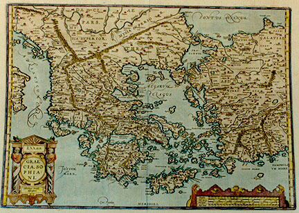
Title: (in Greek lettering:) HEllas. | GRAE:|CIA, SO:|PHIA:|NI.|"Abrahamo Ortelio | descriptore". [Hellas or Greece after Sophianus, depicted by Abraham Ortelius]. (Bottom, left of centre:) "Cum Priuilegio" [With privilege].
Plate size: 350 x 498 mm.
Scale: 1 : 2,500,000
Identification number: Ort 215 (Koeman/Meurer: 3P, Karrow: 1/131, van der Krogt AN: 7800H:31).
Occurrence in Theatrum editions and page number:
1579L2Add70c (250 copies printed) (second textline ends: describuntur.Prima & vera ; last line, centred like 2 lines above it: psere Strabo & Pausanias.),
1579L(A)93 (250 copies printed) (second text line ends: describuntur. Prima & vera ; last line, centred like 2 lines above it: psere Strabo& Pausanias. ; page number 93 positioned below space between Græciam and an- of third line from the bottom.),
1579L(B)93 (250 copies printed) (second text line ends: vera ; last line, centred like two lines above it: psere Strabo & Pausanias. ; page number 93 positioned below space below Græciam of third line from the bottom.),
1580G2Add70c (50 copies printed), (last line, centred like 6 lines above it, in Gothic script: Pausanias. Identical to 1580/1589G except for page number.),
1580/1589G92 or blank (350 copies printed) (identical to 1602G except for page number; last line, centred like 6 lines above it, in Gothic script: Pausanias.),
1581F93 (400 copies printed) (last line, left aligned: Grece en tres-grande diligence.),
1584L110 or 112 (750 copies printed) (last line, centred like two lines above it: psere Strabo & Pausanias.),
1587F111 (250 copies printed) (last line, left aligned: Grece en tresgrande diligence.),
1592L13 (525 copies printed) (last line, left aligned: ceteros diligentissimè descripsere Strabo & Pausanias.),
1595LQ (500 copies printed) (last line, left aligned: niam,in Achaicis:& Vitruuium 3.cap.1.),
1598F119 (525 copies printed) (last line, left aligned: ne Grece en tres-grande diligence.),
1601Lxxvij (200 copies printed) (last line, left aligned: in Achaicis: & Vitruuium 4.cap 1.),
1602G25 (250 copies printed) (identical to 1580/1589G except for page number; last line, centred like 6 lines above it, in Gothic script like the entire text: Pausanias.),
1603L rarely xxvij, mostly xxix (300 copies printed) (text and page number, but not typesetting, identical with the editions 1609/1612S/L; page number xxix below the words consule Pausaniam ; last line, left aligned: Achaicis:& Vitruuium 4. cap. 1.),
1606Exxvij (300 copies printed) (last line, left aligned: ter of his fifth booke of Architecture.),
1608/1612Ixxix (300 copies printed) (last line, left aligned: contezza, studii Pausania nell'Achaia, nel 4.lib.al cap. 1. Vitruuio.),
1609/1612Sxxix (text in Latin) = 1609L/1612Lxxix (600 copies printed) (text and page number, but not typesetting, identical to 1603L. Page number xxix below the word vides ; last line, left aligned: Achaicis:& Vitruuium 4. cap. 1.),
1618BertiusHHH (200 copies printed) (last line, left aligned: cis: & Vitruuium 4.cp.1.),
1624P/1641Sxxxiij (1025 copies printed) (last line, second column, left aligned: truuium lib. 4. cap. 1.).
Approximate number of copies printed: 7275.
States: 215.1 as described.
215.2: between 1587 and 1592 the hatching along the coastlines was extended from 3 to 5 mm; the hatching on the pillar behind the right figure in the title cartouche, lower left, was changed from horizontal to vertical.
Remarks: Bertius bought a number of sheets with this map and included the map in his historical 1618 atlas "Theatrum Geographiæ Veteris", using the 1609/1612L Theatrum text, but reset.
Cartographic sources: Nikolaus Sophianos (abt. 1500-1552 or later) made a first draft of a map of Greece around 1540 which was published by Johannes Oporinus in Basel in 1545 as an eight block woodcut map, and in 1552 in Rome as a four sheet engraved map (Meurer p. 241-242, Karrow 71/1 p. 495-498).
References: G. Zacharkis (1974) A Catalogue of printed maps of Greece and the Greek regions, "Map Collector's Circle" nrs. 98, 102; G. Tolias (2006) Nikolaos Sophianos' "Totius Graeciae Descriptio": The Resources, Diffusion and Function of a 16th Century Antiquarian Map of Greece; "Imago Mundi" 58(2):150-182.
For questions/comments concerning this page, please e-mail info@orteliusmaps.com.