Cartographica Neerlandica Background for Ortelius Map No. 184
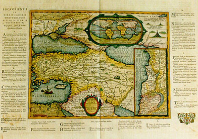
Title: "Rdo. Dño. | D. Adr. Stalpartio | Abb. Togerlêsi digniso.d." | LVMEN | HISTORIARVM | per Orientem. | "illustrandis | Biblijs sacris, Martyro-|logio, et alijs multis". | Concinn. Fran. Hareio | ANTVERPIÆ. [For lord D. Adrian Stalpartius, dignified abbot of Toglerensum, is this Historical Enlightenment of the East, to illustrate the Holy Bible, the list of martyrs and many other matters. Made by Franciscus Hareius of Antwerp]. (Inset top right, oval, 70 x 130 mm:) Typus Orbis ad Investigandum Ophir [World map to find Ophir [legendary land of gold, cf. Kings 9:26-28]]. (Inset bottom right, 175 x 80 mm:) IVDÆÆ | "amplior descriptio". [A more elaborate depiction of Judæa]. (Plate surrounded by text left, below and right of plate, providing information on biblical places, see further below). (Upper left:) Æquor Iasonio pulsatum remige primum. [Sea which was first explored through rowing by Jason]. (Top left:) "Semper extra in Propontidem côfluit, et tamen salsum est | magnaque copia piscium abundat". [There is always more water flowing into Propontis, which is salt, and there is a great quantity of fish here.] (Bottom left:) "Pars Oasis magnæ | quo Scelestißimi | relegabantur". [Part of a large oasis to which the most serious criminals are being sent.] (Top right:) "Nempe hic Tartari sub suo magno Cham | (id est imperatore) vagantur, quantum est | sextum huius chartæ; piscantes, venãtes, et | prædantes". [Here the Tartars roam under their great Cham (that is, their emperor) of which this map shows only a sixth part, fishing, hunting and robbing.] (Right top:) "Baschiridorum horda. | Loca signata sunt quo côveniunt | utpote millæ hic ciuitates". [The tribe of the Baschiridi. The places have been marked where they gather, for there are a thousand communities here.]
Plate size: 273 x 351 mm.
Scale: 1 : 10,000,000.
Identification number: Ort 184 (Koeman/Meurer: 42P, not in Karrow, vdKrogtAN: 0301H:32).
Occurrence in Theatrum editions and page number:
1624Pvj (1000 copies printed)(last line second column first text page: Neceuan , atque in ipsa Persia Latino Catholi-/coque) ; last line second column second text page, left aligned: mæ educandos.),
1641Svj (25 copies printed), identical to 1624P; (last line second column first text page, right aligned: Neceuan , atque in ipsa Persia Latino Catholi-/coque ; last line second column second text page, left aligned: mæ educandos.).
Approximate number of copies printed: 1025.
States: 184.1 only
Cartographic sources: Franciscus Haræus, a geographer from Antwerp who designed a globe in 1617, and who contributed to the atlas Orbis Antiquis made in 1653 by Georg Hornius from Leiden, which contains maps closely copied from Ortelius' Parergon.
For questions/comments concerning this page, please e-mail info@orteliusmaps.com.