Cartographica Neerlandica Background for Ortelius Map No. 109
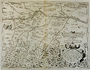
Title: "Tipus" | VINDELICIĆ | SIVE VTRIVSQVE, | BAVARIAE, SECVNDVM | "antiquum & recentiorem situm, ab Joanne Auen:|tino olim descriptus, Principibusque eiusdem | regionis dedicatus, atque Lands:|huti editus Anno ŕ | Christo nato. 1533". [A map of Vindelica or also Bavaria, the second ancient and modern site, once depicted by Johannes Aventinus, dedicated to the leaders of this region and of Landshut, published in the year since Christ's birth. 1533]. (Top left:) "Cum privilegio". [With privilege] (Left edge, on banner:) "Antiqua:|rum |civitatum | rudera | notătur | sic". [followed by a triangle symbol] [The ruins of ancient cities are indicated in this way.] (Top centre:) "Nariscos vocat Tacitus Bauariam | quć est vltra Danubium, versus Sep:|tentrionem : hodić Nordgeu". [Tacitus calls Bavaria beyond the Danube towards the North Narisci, nowadays it is called Nordgeu.] (Right centre:) VINDELICI "vocantur ŕ | Grecis Latinisque auctoribus, qui vtram:|que Bauariam inter Danubium Oenum | & Leccam fluuium habitant". [Those who live beyond Bavaria between the rivers Danube, Inn and Lech are by Greek and Latin authors called Vindelici.] (Middle centre:) "Hćc punctorű series Bauariam | superiorę ab Inferiori diuidit". [This dotted line separates Higher from Lower Bavaria.] (Top right:) "Hercinić siluić pars quć | Bohemian cingit". [Part of the Hercinian forest which surrounds Bohemia.] Middle right: NORICVM ET NORICOS "vocant | scriptores Bauariam cis Oenum fluuium". [The writers call the area from Bavaria to the river Inn Noricum, and its inhabitants Norici].
Plate size: 330 x 420 mm
Scale: 1 : 650,000
Identification number: Ort 109 (Koeman/Meurer: 29, Karrow: 1/39, vdKrogtAN: 2660:31A).
Occurrence in Theatrum editions and page number:
1570(AC)L29 (225 copies printed) (third line from bottom begins: omnia, quć ; last line, centred like three lines above it: historici Boiorum Annales.),
1570L(B)29 (100 copies printed) (third line from bottom begins: Sed qui omnia, quć; last line, centred like two lines above it: historici Boiorum Annales.),
1571L29 (275 copies printed) (third line from bottom begins : Sed qui ; last line, centred like two lines above it: historici Boiorum Annales.),
1571/1573D29 (350 copies printed) (last line, centred like 4 lines above it: daer in versterckt.),
1572G29Koler (pasted over p.29 of a 1570L edition; few copies printed) (last line, left aligned, maily in Gothic script: les zur beschreibung dises Landes gehörig/wissen wil/der lese die Annales oder Jarbücher Ioannis Auentini, der ein sehr fleissiger Historicus ist.),
few 1572/1573G29 (100 copies printed) (no data),
1572/1574F29 (225 copies printed) (last line, centred like 4 lines above it: de Saltzbourg.),
some 1573L(A)29 (25 copies printed) (no data).
Approximate number of copies printed: 1300.
States: 109.1 only.
Cartographic sources: Johannes Aventinus (1477-1534) (Karrow 9/5, p. 71-77, Meurer p. 110-111).
Remarks: As early as 1571, we also find editions with the later plate of Bavaria by Apian (Ort 110), or even editions with both the early and the late plate.
For questions/comments concerning this page, please e-mail info@orteliusmaps.com.