Cartographica Neerlandica Background for Ortelius Map No. 1
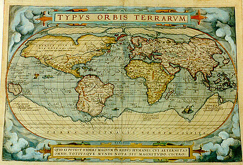
Title: TYPVS ORBIS TERRARVM. [Image of the countries of the world]. (bottom cartouche:) QVID EI POTEST VIDERI MAGNVM IN REBVS HVMANIS, CVI AETERNITAS | OMNIS, TOTIVSQVE MVNDI NOTA SIT MAGNITVDO. CICERO: [Who can consider human affairs to be great, when he comprehends the eternity and vastness of the entire world? Cicero, [Tusculan Disputationes 4.37]] (bottom left:) Cum priuilegio [with privilege]. (bottom right:) Franciscus Hogenbergus sculpsit. [engraved by Franciscus Hogenberg]. (Lower left:) "Hanc continentem | Australem, nonnulli | Magellanicam regionem | ab eius inuentore nuncupant".) [This Southern continent is by some called the Magellan region after its discoverer".] (Lower left:) "Noua Guinea | nuper inuenta|quć an sit insula|an pars continentis|Australis incertű est") [New Guinea, recently discovered. Whether this is an island or part of the Southern continent is uncertain.] (Lower right:) "Vastißimas hic eße | regiones ex M Pauli Ven:et | Lud.Vartomann. scriptis pe:|regrationibus constat". [These regions are very extended, as can be seen in the writings of Paulus Venetus and the travels of Ludovicus Vartomannus.] (Lower right:) "Psitacorum regio | sic a Lusitanis appellata ob | incredibilem earum auium ibidem magnitudem". [This region is by the Portuguese called "of the Psitaci" because of the incredible number of birds of the same size].
Plate size: 337 x 493 mm
Scale: 1 : 80,000,000
Identification number: Ort 1 (Koeman/Meurer: 1, Karrow: 1/6, van der Krogt AN: 0001:31A)
Occurrence in Theatrum editions and page number:
1570L(AC)1 (225 copies printed)(last line second column: populorumque mores & ritus.),
1570L(B)1 (100 copies printed)(last line second column: res & ritus.),
1571L1 (275 copies printed)(last line first column:) IOACHIMVS VADIANVS; (second column:) res & ritus.),
1571D/1573D1 (350 copies printed)(last line, centred like two lines above it, in Gothic script: dit hebben wij hier alleene int corte aenwijsen willen.),
1572F1 (150 copies printed)(last line, centred: il en seroit bien vn śuure entier : ce que nous en auons dit, a esté fait comme en passant.),
1572G1 (pasted over p.1 of a 1570L edition; few copies printed) (last line above sources, in Gothic script: zubeschreiben.),
1572/1573G1 (225 copies printed) (last line, centred like 3 lines above it, in cursive script like the entire text: "der solte woll ain gantz buch darvon machen: Wir aber habent allain in das bedeuten wollen".),
1573L(AB)1 (75 copies printed) (Version A has capital B of ORBIS in title above L of TABULA in first text line; version B has capital B of ORBIS in title above last A of TABULA. Both versions have 18th line of text, cursive except for the last two words: "uerit,quam tandem portionem eius defunctus obtineat?" Hactenus ille. ; last line above two columns, full width: res,& quicquid cognitione in iis ac scitu dignum (version A) dignű (version B) videbatur, describere aggressi sunt ex Veteribus),
1574F1 (75 copies printed)(last line, centred: il en seroit bien vn śuure entier : ce que nous en auons dit, a esté fait comme en passant.),
1574L1 (175 copies printed)(large page number, 11 mm, last line, left column : PETRVS IOANNES OLIVARIVS in Melam: right column: FRANCISCVS BELLEFORESTIVS,Gallice.),
1575L1 (100 copies printed)(small page number, 7 mm, last line, left column : PETRVS IOANNES OLIVARIVS in Melam: right column: FRANCISCVS BELLEFORESTIVS, Gallice.),
1579L(A)1 (250 copies printed) (last line, left column: PETRVS IOANNES OLIVARIVS in Melam; right column ends one line higher than left column),
1579L(B)1 (250 copies printed) (last line, left column: PETRVS IOANNES OLIVARIVS in Melam; right column: FRANCISCVS BELLEFORESTIVS,Gallicč),
1580G1 (175 copies printed, the remainder is Ort2), (last part of text in two columns; left column, partly in Gothic script like the entire text: Ptolemeum.Zacharias Lilius Vicent, von gelegenheit der Welt. (right column:) zösischer Spraach.),
1581F1 (400 copies printed) (last line, left aligned: seroit bien vn śuure entier: ce que nous en auons dit,est seulement fait comme en passant.),
1584L1, (750 copies printed)(last line, left column: GVALTERVS LVDOVICVS, in Speculo Orbis; right column, one line higher than previous: FRANCISCVS BELLEFORESTIVS, Gallicč.),
some 1598D1 (25 copies printed).
Approximate number of copies printed: 3600.
States: (as described) 1.1
1.2 In 1574L the hachuring around the Cicero quote which obliquely goes from upper left to lower right is augmented under the "clasps" which are found at the left and right of the cartouche, not quite at its ends, by a different hachuring going from lower left to upper right.
1.3 In 1575L, bolt impressions appear in the lower left corner, to repair a crack. According to Shirley, this is already the case in 1570L.
1.4 In 1579, the crack is somewhat mended and less visible. Some reworking of the clouds.
1.5 In 1584 the date "1584" is added to the right of "Hogenbergus sculpsit".
1.6 After 1584, this date is amended to "1585".
Note that the oblique hachurung of the frame around the Cicero quote at the bottom becomes progressive fainter with usage of the plate. In 1570L the entire frame is filled with hachuring, whereas in 1584L the hachuring has almost disappeared.
Cartographical sources: Gerard Mercator's 1569, Gastaldi's 1561 world map and Diego Gutierrez' portolan map of the Atlantic (Meurer p. 35, Karrow 56/17, 37/1 p. 389-392, 285-287). Next to the list at the bottom of the text, Ortelius mentions in his Catalogus Auctorum the world maps by Peter ab Aggere from Mechelen, Sebastian Cabotus from Venice, Laurentius Fries from Antwerp, Jacobus Gastaldi, Gemma Frisius from Antwerp, Guicciardinus from Antwerp, Doco ab Hemminga Frisius, and Orontius Finćus from Paris.
References: Shirley (1993) map 122. Shirley (1998) The World Maps in the "Theatrum", p. 171-184, in Van den Broecke, van der Krogt and Meurer (eds.) "Abraham Ortelius and the First Atlas", HES Publishers, 1998. Lucia Nuti (2003) The World Map as an Emblem: Abraham Ortelius and the Stoic Contemplation, Imago Mundi 55: 38-55.
Remarks: This map is replaced from 1586 onwards by plate 2, on which in the lower cartouche we find .."AETER:|NITAS".. broken over the two lines, whereas it is unbroken on this plate.
On the basis of Ortelius' correspondence, Hessels is positive that this map Ort 1 was issued as early as 1561 (see his p. xxiv), since the letter (11) of Scipio Fabius, dated 16 June 1561 refers to some "typos" maps he and his brother have received. In Scipio Fabius' letter (15) of 14 April 1565, he refers to receiving the map "typum totius terrarum" and expresses his admiration for it. However, it is quite conceivable that Fabius' remarks refer to copies (or sheets) of Ortelius' 8-sheet wall map of the world, commonly dated 1564.
The oval shape goes back to Apianus and/or Bordonius.
This Ort 1 map was reproduced with quite some detail on a stamp of 34 Francs issued by the Belgian government in the year 2000 to commemorate the 500th birthday anniversary of Charles the Fifth, who features prominently on this stamp, seated on a horse and covering most of the Americas and the South Pole. A very similar stamp seems to have been produced by Spain.
As the first world map occurring in the first regular atlas, this map is of fundamental importance in the history of cartography.
In May 2008 an American sent me a photograph of this map which to the right of Hogenberg's signature as the engraver showed the text EDIZ.P.V. right under the name CICERO, claiming to have an unrecorded new state. No plate mark was visible on the photograph. I asked for a new photograph with a ruler along the top and left side. The ruler showed that both dimensions were almost 2 cms too long. I offered to inspect it personally, which was declined. I am convinced this map was a fake.
For questions/comments concerning this page, please e-mail info@orteliusmaps.com.