Cartographica Neerlandica Background for Ortelius Map No. 85
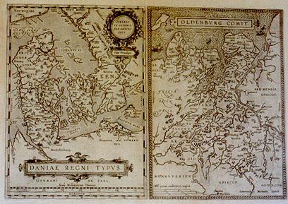
Title: DANIAE REGNI TYPVS. [Image of the kingdom of Denmark] (Top right cartouche:) CORNELI:|VS ANTONIA:|DES DESCRI:|PSIT. [Designed by Cornelius, son of Antonius] "Cum priuilegio." [With privilege]. - OLDENBVRG COMIT. [Duchy of Oldenburg]. (Bottom right corner:) "Laurentius Michaelis describ". [Designed by Laurentius Michaëlis].
Plate size: 344 x 498 mm. Two maps on one plate.
Identification number: Ort 85 (koeman/Meurer: 101ab, Karrow 1/144).
Title 85a: Danić
Scale: 1 : 2,500,000.
Size: 344 x 246 mm.
Identification number: Ort 85a (Koeman/Meurer: 101a, van der Krogt AN: 1500:31B).
States: 85a.1 only.
Cartographic sources: central part of Cornelis Anthoniszoon (1499-1557) Caerte van Oostland; Germany map of Sgrooth; Scandinavia map of Olaus, and possibly Marcus Jordanus' 1552 map of Denmark (Karrow p. 44-45, Meurer p. 104-105). In the "Catalogus Auctorum" Ortelius claims that he has received a manuscript map from Marcus Jordanus depicting Jutland. The "Catalogus" also mentions Heinrich Rantzovius as the author of a Denmark map.
Title 85b: Oldenburg
Scale: 1 : 300,000.
Size: 346 x 245 mm.
Identification number: Ort 85b (Koeman/Meurer: 101b, van der Krogt AN: 2320:31B).
States: 85b.1 only
Cartographic sources: Laurens Michaelis' 1579 map of East Frisia, published as a single sheet by de Jode, and incorporated in the 1593 edition of his Speculum (Meurer p. 201-202).
Occurrence in Theatrum editions and page number:
1584L3Addblank (100 copies printed) (identical with 1584L, but here without page number; last line, left aligned: Andreas Hoppenrodius,in suo Stemmatum libro.),
1584L44 (750 copies printed) (identical with 1584L3Add, but here with page number; last line, left aligned: Andreas Hoppenrodius,in suo Stemmatum libro.),
1584G3Add23 page number in upper right corner (75 copies printed) (last line, left aligned, in Gothic script like the entire text: Stammbuch etwas.),
1585F3Add14 (75 copies printed) (same text but different typesetting as compared to 1587F; last line, left aligned: Hoppenrode touche quelque chose des Contes de ceste prouince au liure de ses Genealogies.),
1587F44 (250 copies printed) (same text as 1585F3Add but different typesetting; last line, left aligned: touche quelque chose des Contes de ceste prouince au liure de ses Genealogies.),
1588S44 (300 copies printed) (last line, left aligned: tiene algunas cosas Andres Hoppenrodio en su libro Stemmatum.),
1592L46 (525 copies printed) (last line, left aligned: regionis qućdam habet Andreas Hoppenrodius,in suo Stemmatum libro.),
1598F51 (525 copies printed) (last line, left aligned: André Hoppenrode touche quelque chose des Contes de ceste prouince au liure de ses Genealogies.).
Approximate total number of copies printed: 2600.
Remarks: in 1595, a new plate of Ort 85a appears as Ort 86a (although the 1598 French edition retains the old plate). This new plate has CORNE:|LIUS instead of the present CORNELI:|US in the cartouche. A new plate of Oldenburg appears as Ort 90B. That late plate has cursive capitals in "MONASTERIENS. | EPISCOP". whereas we find straight capitals on this plate.
For questions/comments concerning this page, please e-mail info@orteliusmaps.com.